
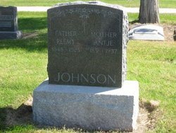
Antje Johanna Johnson Johnson
| Birth | : | 25 Jan 1851 Lower Saxony (Niedersachsen), Germany |
| Death | : | 7 Feb 1937 Blue Hill, Webster County, Nebraska, USA |
| Burial | : | Rock Cave Cemetery, Rock Cave, Upshur County, USA |
| Coordinate | : | 38.8367004, -80.3494034 |
| Plot | : | SW section Lot 159 |
| Description | : | The German name Jansen was changed to Johnson during immigration and Antje was changed to Anna. ~ Added by Mike Benker. Antje Johnson married Reemt Johnson on 1st Aug 1873 at the German United Evangelical Lutheran Church by Rev A Schoenhut at Minonk, Woodford County, Illinois - Thru mergers, this Church is now known as St Paul's United Church of Christ at Minonk, Illinois. ` from Charles Buss |
frequently asked questions (FAQ):
-
Where is Antje Johanna Johnson Johnson's memorial?
Antje Johanna Johnson Johnson's memorial is located at: Rock Cave Cemetery, Rock Cave, Upshur County, USA.
-
When did Antje Johanna Johnson Johnson death?
Antje Johanna Johnson Johnson death on 7 Feb 1937 in Blue Hill, Webster County, Nebraska, USA
-
Where are the coordinates of the Antje Johanna Johnson Johnson's memorial?
Latitude: 38.8367004
Longitude: -80.3494034
Family Members:
Parent

Spouse

Siblings
Children
Flowers:


Nearby Cemetories:
1. Rock Cave Cemetery
Rock Cave, Upshur County, USA
Coordinate: 38.8367004, -80.3494034
2. Chestnut Flat Cemetery
Rock Cave, Upshur County, USA
Coordinate: 38.8391991, -80.3811035
3. McDowell Cemetery
Frenchton, Upshur County, USA
Coordinate: 38.8632450, -80.3444930
4. Ash Family Cemetery
Frenchton, Upshur County, USA
Coordinate: 38.8648224, -80.3427582
5. Kanawha Run Church Cemetery
French Creek, Upshur County, USA
Coordinate: 38.8347751, -80.3109749
6. Kanawha Run Cemetery
Arlington, Upshur County, USA
Coordinate: 38.8348770, -80.3108990
7. Cow Run Cemetery
Rock Cave, Upshur County, USA
Coordinate: 38.8065910, -80.3588530
8. Wimer Cemetery
Rock Cave, Upshur County, USA
Coordinate: 38.8407593, -80.3906555
9. Arlington Cemetery
Arlington, Upshur County, USA
Coordinate: 38.8020400, -80.3416910
10. Cow Run School Cemetery
Rock Cave, Upshur County, USA
Coordinate: 38.8094090, -80.3816080
11. Phillips Family Cemetery
Upshur County, USA
Coordinate: 38.8628100, -80.3150700
12. Brown Cemetery
Rock Cave, Upshur County, USA
Coordinate: 38.8065600, -80.3857820
13. Heaston Cemetery
Kanawha Head, Upshur County, USA
Coordinate: 38.7969100, -80.3776400
14. Beechtown Cemetery
Frenchton, Upshur County, USA
Coordinate: 38.8838997, -80.3494034
15. Union Hill Cemetery
Lewis County, USA
Coordinate: 38.8734350, -80.3971630
16. Taylor Chapel Cemetery
Crawford, Lewis County, USA
Coordinate: 38.8497370, -80.4145380
17. Saul Smith Farm Cemetery
Crawford, Lewis County, USA
Coordinate: 38.8491950, -80.4149770
18. Center Chapel Cemetery
French Creek, Upshur County, USA
Coordinate: 38.8454790, -80.2822450
19. French Creek Memorial Gardens
Upshur County, USA
Coordinate: 38.8827910, -80.3054480
20. Lee Cemetery
Kanawha Head, Upshur County, USA
Coordinate: 38.7787000, -80.3431390
21. Waterloo Cemetery
Carter, Upshur County, USA
Coordinate: 38.8571940, -80.2783510
22. French Creek Presbyterian Church Cemetery
French Creek, Upshur County, USA
Coordinate: 38.8856020, -80.3022650
23. Salem Ridge Cemetery
Gaines, Upshur County, USA
Coordinate: 38.7821200, -80.3130500
24. Bennett Cemetery
Upshur County, USA
Coordinate: 38.7749063, -80.3555116