
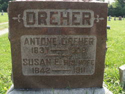
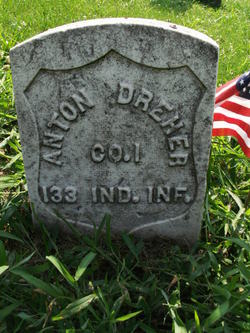
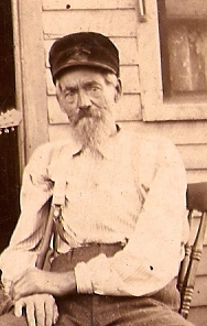
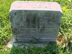
Anton Dreher
| Birth | : | 19 Jan 1837 Baden-Württemberg, Germany |
| Death | : | 24 Aug 1904 Tecumseh, Vigo County, Indiana, USA |
| Burial | : | St John The Baptist Churchyard, Tunstall, City of Lancaster, England |
| Coordinate | : | 54.1596600, -2.5924200 |
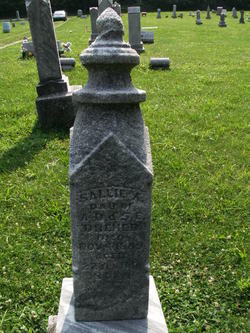
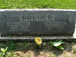
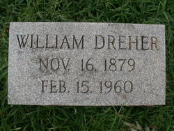
| Description | : | Anton was the son of Balthasar and Maria (Bregenzer) Dreher. In 1855 he emigrated to America with his brother Christian and joined his brother Ottmar in Vigo Co. where he worked as a cooper. During the Civil War he served in Co. I, 133rd Ind. Inf. He married Susan E. Purcell on May 1, 1865 and they were the parents of 4 children: Sallie A., Herman B., Bessie and William. The spelling of his name and date of death are incorrect on his tombstone. It was probably placed there years after his death. |
frequently asked questions (FAQ):
-
Where is Anton Dreher's memorial?
Anton Dreher's memorial is located at: St John The Baptist Churchyard, Tunstall, City of Lancaster, England.
-
When did Anton Dreher death?
Anton Dreher death on 24 Aug 1904 in Tecumseh, Vigo County, Indiana, USA
-
Where are the coordinates of the Anton Dreher's memorial?
Latitude: 54.1596600
Longitude: -2.5924200
Family Members:
Spouse

Children
Flowers:


Nearby Cemetories:
1. St John The Baptist Churchyard
Tunstall, City of Lancaster, England
Coordinate: 54.1596600, -2.5924200
2. St. Michael the Archangel Churchyard
Whittington, City of Lancaster, England
Coordinate: 54.1807620, -2.6148790
3. St Wilfrids Churchyard
Melling, City of Lancaster, England
Coordinate: 54.1346900, -2.6165100
4. St John The Baptist Churchyard
Arkholme, City of Lancaster, England
Coordinate: 54.1406220, -2.6307800
5. Saint Peter's Churchyard
Leck, City of Lancaster, England
Coordinate: 54.1836860, -2.5485980
6. All Saints Churchyard
Burton-in-Lonsdale, Craven District, England
Coordinate: 54.1437630, -2.5357130
7. St James the Less Churchyard
Tatham, City of Lancaster, England
Coordinate: 54.1190100, -2.6043200
8. St Mary the Virgin Churchyard
Kirkby Lonsdale, South Lakeland District, England
Coordinate: 54.2036550, -2.5976790
9. Friends Burial Group
Bentham, Craven District, England
Coordinate: 54.1265450, -2.5374290
10. St. John the Baptist Churchyard
Bentham, Craven District, England
Coordinate: 54.1180880, -2.5454540
11. St. John The Evangelist Churchyard
Gressingham, City of Lancaster, England
Coordinate: 54.1233910, -2.6557800
12. Holy Trinity Churchyard
Casterton, South Lakeland District, England
Coordinate: 54.2113570, -2.5768860
13. St. Wilfred Priory
Hornby, City of Lancaster, England
Coordinate: 54.1143640, -2.6405490
14. St. Margaret's Churchyard
Hornby, City of Lancaster, England
Coordinate: 54.1114000, -2.6362000
15. Holy Trinity Churchyard
Wray, City of Lancaster, England
Coordinate: 54.1022960, -2.6081510
16. St John's Churchyard
Hutton Roof, South Lakeland District, England
Coordinate: 54.2029600, -2.6615600
17. St Oswald Churchyard
Thornton-in-Lonsdale, Craven District, England
Coordinate: 54.1573600, -2.4830810
18. St Margaret Churchyard
Bentham, Craven District, England
Coordinate: 54.1146000, -2.5087300
19. St Mary Churchyard
Ingleton, Craven District, England
Coordinate: 54.1540480, -2.4682980
20. All Saints Churchyard
Lupton, South Lakeland District, England
Coordinate: 54.2217340, -2.6649730
21. St Bartholomew Churchyard
Barbon, South Lakeland District, England
Coordinate: 54.2365440, -2.5682800
22. St. Chad's Churchyard
Claughton, City of Lancaster, England
Coordinate: 54.0931310, -2.6643990
23. St Peter's Churchyard
Mansergh, South Lakeland District, England
Coordinate: 54.2384190, -2.6118450
24. St James Churchyard
Burton-in-Kendal, South Lakeland District, England
Coordinate: 54.1859270, -2.7210310