
| Birth | : | 6 Oct 1834 |
| Death | : | 20 Feb 1909 |
| Burial | : | St Peter Churchyard, Little Thurlow, St Edmundsbury Borough, England |
| Coordinate | : | 52.1335150, 0.4527380 |
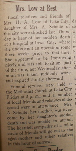
| Description | : | SCHULTE, Arend 1834 20 Feb 1909 Wall Lake Sac Lot 23 ---------- Arend Schulte, born Oct. 6, 1834, died Feb. 20, 1909; wife: Mae Schulte, born Mar. 3, 1835, died Dec. 18, 1919. |
frequently asked questions (FAQ):
-
Where is Arend Schulte's memorial?
Arend Schulte's memorial is located at: St Peter Churchyard, Little Thurlow, St Edmundsbury Borough, England.
-
When did Arend Schulte death?
Arend Schulte death on 20 Feb 1909 in
-
Where are the coordinates of the Arend Schulte's memorial?
Latitude: 52.1335150
Longitude: 0.4527380
Family Members:
Spouse

Children
Flowers:


Nearby Cemetories:
1. St Peter Churchyard
Little Thurlow, St Edmundsbury Borough, England
Coordinate: 52.1335150, 0.4527380
2. Chapel House Graveyard
Great Thurlow, St Edmundsbury Borough, England
Coordinate: 52.1292493, 0.4502808
3. All Saints Churchyard
Great Thurlow, St Edmundsbury Borough, England
Coordinate: 52.1259500, 0.4538200
4. All Saints Churchyard
Little Bradley, St Edmundsbury Borough, England
Coordinate: 52.1417700, 0.4562500
5. St Mary the Virgin Churchyard
Great Bradley, St Edmundsbury Borough, England
Coordinate: 52.1516228, 0.4457830
6. St. Mary's Churchyard
Great Wratting, St Edmundsbury Borough, England
Coordinate: 52.1063290, 0.4636470
7. St. Mary's Churchyard
Little Wratting, St Edmundsbury Borough, England
Coordinate: 52.1013310, 0.4666450
8. All Saints Churchyard
Barnardiston, St Edmundsbury Borough, England
Coordinate: 52.1102600, 0.4984100
9. St Peter Churchyard
Carlton, South Cambridgeshire District, England
Coordinate: 52.1505470, 0.3982180
10. St Mary the Virgin Churchyard
Withersfield, St Edmundsbury Borough, England
Coordinate: 52.1030300, 0.4095000
11. St Peter and St Paul Churchyard
Kedington, St Edmundsbury Borough, England
Coordinate: 52.0953040, 0.4876180
12. Haverhill Cemetery
Haverhill, St Edmundsbury Borough, England
Coordinate: 52.0867860, 0.4336830
13. St Margaret Antioch Parish Churchyard
Cowlinge, St Edmundsbury Borough, England
Coordinate: 52.1658530, 0.5112440
14. St Augustine of Canterbury Churchyard
Burrough Green, East Cambridgeshire District, England
Coordinate: 52.1700000, 0.4000000
15. St Mary the Virgin Churchyard
Haverhill, St Edmundsbury Borough, England
Coordinate: 52.0827620, 0.4379840
16. Hundon Chapel
Hundon, St Edmundsbury Borough, England
Coordinate: 52.1106800, 0.5362500
17. All Saints Churchyard
Hundon, St Edmundsbury Borough, England
Coordinate: 52.1097420, 0.5375940
18. All Saints Churchyard
Kirtling, East Cambridgeshire District, England
Coordinate: 52.1909900, 0.4663280
19. St Mary's Churchyard
Weston Colville, South Cambridgeshire District, England
Coordinate: 52.1530000, 0.3620000
20. St. Margaret of Antioch Churchyard
Stradishall, St Edmundsbury Borough, England
Coordinate: 52.1434400, 0.5529300
21. St Mary Churchyard
Sturmer, Braintree District, England
Coordinate: 52.0676840, 0.4644960
22. St Andrew's Church
West Wratting, South Cambridgeshire District, England
Coordinate: 52.1461000, 0.3456200
23. All Saints Churchyard
Horseheath, South Cambridgeshire District, England
Coordinate: 52.1018130, 0.3547390
24. St Mary the Less Churchyard
Westley Waterless, East Cambridgeshire District, England
Coordinate: 52.1805000, 0.3650000