
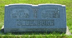


Arthur Friedrich Ollenburg
| Birth | : | 6 Mar 1898 Garner, Hancock County, Iowa, USA |
| Death | : | 6 Sep 1925 Garner, Hancock County, Iowa, USA |
| Burial | : | Holy Cross Churchyard, Middlezoy, Sedgemoor District, England |
| Coordinate | : | 51.0937200, -2.8941260 |
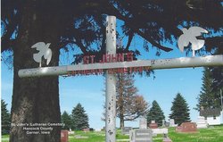
| Description | : | Arthur, son of Herman H. and Minnie (Schultz) Ollenburg was born on the family nordth east of Garner on March 6, 1898. He was baptized, confirmed and educated at St. John's Lutheran Church and School. Arthur passed away September 6, 1925. Services were held at St. John's Lutheran Church with burial at Sst. John's Cemetery. |
frequently asked questions (FAQ):
-
Where is Arthur Friedrich Ollenburg's memorial?
Arthur Friedrich Ollenburg's memorial is located at: Holy Cross Churchyard, Middlezoy, Sedgemoor District, England.
-
When did Arthur Friedrich Ollenburg death?
Arthur Friedrich Ollenburg death on 6 Sep 1925 in Garner, Hancock County, Iowa, USA
-
Where are the coordinates of the Arthur Friedrich Ollenburg's memorial?
Latitude: 51.0937200
Longitude: -2.8941260
Family Members:
Parent
Siblings
Flowers:


Nearby Cemetories:
1. Holy Cross Churchyard
Middlezoy, Sedgemoor District, England
Coordinate: 51.0937200, -2.8941260
2. Othery Cemetery
Othery, Sedgemoor District, England
Coordinate: 51.0771222, -2.8906189
3. Westonzoyland Cemetery
Westonzoyland, Sedgemoor District, England
Coordinate: 51.1078900, -2.9264440
4. St. Mary's Churchyard
Westonzoyland, Sedgemoor District, England
Coordinate: 51.1087000, -2.9273800
5. The Old Chapel
Westonzoyland, Sedgemoor District, England
Coordinate: 51.1077425, -2.9285237
6. Ebenezer Chapelyard
Burrowbridge, Taunton Deane Borough, England
Coordinate: 51.0727744, -2.9222989
7. St Michael Churchyard
Burrowbridge, Taunton Deane Borough, England
Coordinate: 51.0698090, -2.9174960
8. Westonzoyland Cemetery New
Westonzoyland, Sedgemoor District, England
Coordinate: 51.1096271, -2.9349336
9. Sutton Mallet Churchyard
Sutton Mallet, Sedgemoor District, England
Coordinate: 51.1282540, -2.8974536
10. Northmoor Green St. Peter & St. John Churchyard
North Petherton, Sedgemoor District, England
Coordinate: 51.0841694, -2.9486911
11. Blessed Virgin Mary Churchyard
Moorlinch, Sedgemoor District, England
Coordinate: 51.1280000, -2.8616000
12. Athelney Abbey (Defunct)
Athelney, Sedgemoor District, England
Coordinate: 51.0593000, -2.9345800
13. Saint Andrew's Churchyard
Aller, South Somerset District, England
Coordinate: 51.0554000, -2.8627000
14. St. Michael and All Angels Churchyard
Greinton, Sedgemoor District, England
Coordinate: 51.1240140, -2.8408590
15. St. Francis Churchyard
Stawell, Sedgemoor District, England
Coordinate: 51.1404200, -2.9046660
16. St. Andrew's Churchyard
High Ham, South Somerset District, England
Coordinate: 51.0760320, -2.8218400
17. High Ham Cemetery
High Ham, South Somerset District, England
Coordinate: 51.0739931, -2.8216351
18. Church of the Blessed Virgin Mary Churchyard
Chedzoy, Sedgemoor District, England
Coordinate: 51.1344600, -2.9429400
19. East Lyng St Bartholomew
Lyng, Sedgemoor District, England
Coordinate: 51.0553000, -2.9534000
20. The Baptist Chapel
Stoke St Gregory, Taunton Deane Borough, England
Coordinate: 51.0430441, -2.9375476
21. Saint Peter Churchyard
Catcott, Sedgemoor District, England
Coordinate: 51.1494920, -2.8671220
22. Stoke St Gregory
Stoke St Gregory, Taunton Deane Borough, England
Coordinate: 51.0398130, -2.9310570
23. Blessed Virgin Mary Churchyard
Shapwick, Sedgemoor District, England
Coordinate: 51.1405090, -2.8336100
24. Low Ham Church in the Field
High Ham, South Somerset District, England
Coordinate: 51.0583449, -2.8155268