
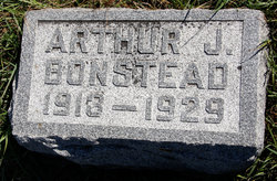
Arthur Joseph Bonstead
| Birth | : | 19 Jun 1913 Palo Alto County, Iowa, USA |
| Death | : | 20 May 1929 Ruthven, Palo Alto County, Iowa, USA |
| Burial | : | Lost Island Lutheran Cemetery, Lost Island Township, Palo Alto County, USA |
| Coordinate | : | 43.1980000, -94.8375000 |
| Plot | : | Lot 82 spot 4 |
| Description | : | Arthur Bonstead died last Monday morning after an Illness after two weeks. He was the son of Mr. and Mrs. A. J. Bonstead of Lost Island township . He was a student of the Graettlnger high school The funeral was held Tuesday afternoon at the home and at Lost Island Lutheran church. The Rev. Mandsager officiated assisted by the Rev. Wlgdahl of Ruthven and the Rev. Anderson of Graettinger. He leaves to mourn his death his father and mother and two brothers. Had he lived until June 19 he would have been 17. The pallbearers... Read More |
frequently asked questions (FAQ):
-
Where is Arthur Joseph Bonstead's memorial?
Arthur Joseph Bonstead's memorial is located at: Lost Island Lutheran Cemetery, Lost Island Township, Palo Alto County, USA.
-
When did Arthur Joseph Bonstead death?
Arthur Joseph Bonstead death on 20 May 1929 in Ruthven, Palo Alto County, Iowa, USA
-
Where are the coordinates of the Arthur Joseph Bonstead's memorial?
Latitude: 43.1980000
Longitude: -94.8375000
Family Members:
Parent
Siblings
Flowers:


Nearby Cemetories:
1. Lost Island Lutheran Cemetery
Lost Island Township, Palo Alto County, USA
Coordinate: 43.1980000, -94.8375000
2. Saint Paul Lutheran Cemetery
Walnut Township, Palo Alto County, USA
Coordinate: 43.1866740, -94.7872050
3. Highland Cemetery
Highland Township, Palo Alto County, USA
Coordinate: 43.1497002, -94.8578033
4. Graettinger City Cemetery
Graettinger, Palo Alto County, USA
Coordinate: 43.2550011, -94.7722015
5. Saint Jacobs Cemetery
Graettinger, Palo Alto County, USA
Coordinate: 43.2546997, -94.7705994
6. Crown Hill Cemetery
Ruthven, Palo Alto County, USA
Coordinate: 43.1328011, -94.8878021
7. Calvary Cemetery
Ruthven, Palo Alto County, USA
Coordinate: 43.1314011, -94.8869019
8. Valley View Cemetery
Walnut Township, Palo Alto County, USA
Coordinate: 43.2428000, -94.7212000
9. Fairview Cemetery
Terril, Dickinson County, USA
Coordinate: 43.2977982, -94.9349976
10. Wallingford Lutheran Cemetery
Wallingford, Emmet County, USA
Coordinate: 43.3128014, -94.7731018
11. High Lake Jack Creek Cemetery
Wallingford, Emmet County, USA
Coordinate: 43.3006500, -94.7000620
12. Dickens Cemetery
Dickens, Clay County, USA
Coordinate: 43.1280000, -95.0155000
13. Evergreen Cemetery
Emmetsburg, Palo Alto County, USA
Coordinate: 43.0940018, -94.6791992
14. Saint Johns Catholic Cemetery
Emmetsburg, Palo Alto County, USA
Coordinate: 43.0913200, -94.6790000
15. Silver Lake Cemetery
Silver Lake Township, Palo Alto County, USA
Coordinate: 43.0386009, -94.8597031
16. Vernon Township Cemetery
Vernon Township, Palo Alto County, USA
Coordinate: 43.1840000, -94.6185000
17. Calvary Cemetery
Silver Lake Township, Palo Alto County, USA
Coordinate: 43.0386009, -94.8613968
18. Fairview Cemetery
Clay County, USA
Coordinate: 43.1899986, -95.0800018
19. Logan Township Cemetery
Clay County, USA
Coordinate: 43.0489006, -94.9747009
20. Saint Patricks Cemetery
Estherville, Emmet County, USA
Coordinate: 43.3843994, -94.8283005
21. Richland Township Cemetery
Terril, Dickinson County, USA
Coordinate: 43.3565323, -94.9927821
22. Center Township Cemetery
Emmet County, USA
Coordinate: 43.3608000, -94.6790000
23. Oak Hill Cemetery
Estherville, Emmet County, USA
Coordinate: 43.3986015, -94.8518982
24. East Side Cemetery
Estherville, Emmet County, USA
Coordinate: 43.4068985, -94.8264008