

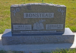
Gerald Oliver Bonstead
| Birth | : | 1 Feb 1911 Palo Alto County, Iowa, USA |
| Death | : | 22 May 1982 Wallingford, Emmet County, Iowa, USA |
| Burial | : | Lost Island Lutheran Cemetery, Lost Island Township, Palo Alto County, USA |
| Coordinate | : | 43.1980000, -94.8375000 |
| Plot | : | Lot 97 spot 3 |
| Description | : | G. 0. [GERALD] BONSTEAD Services for G. 0. (Gerald) Bonstead, 71, were held at 1:30 p.m. Tuesday in the Wallingford Lutheran Church with Pastor Virgil Anderson officiating. Interment was in the Lost Island Cemetery. He died Saturday, May 15, at his home in Wallingford. Mr. Bonstead was born Feb. 1, 1911, in Palo Alto County, the son of Anton and Ings (Paulsen) Bonstead. He received his education in the Graettinger schools andgraduated from Graettinger High School in 1929. On Feb. 11, 1932, he was united in marriage to Inez Paulsen in Palo Alto County. He... Read More |
frequently asked questions (FAQ):
-
Where is Gerald Oliver Bonstead's memorial?
Gerald Oliver Bonstead's memorial is located at: Lost Island Lutheran Cemetery, Lost Island Township, Palo Alto County, USA.
-
When did Gerald Oliver Bonstead death?
Gerald Oliver Bonstead death on 22 May 1982 in Wallingford, Emmet County, Iowa, USA
-
Where are the coordinates of the Gerald Oliver Bonstead's memorial?
Latitude: 43.1980000
Longitude: -94.8375000
Family Members:
Parent
Spouse
Siblings
Children
Flowers:


Nearby Cemetories:
1. Lost Island Lutheran Cemetery
Lost Island Township, Palo Alto County, USA
Coordinate: 43.1980000, -94.8375000
2. Saint Paul Lutheran Cemetery
Walnut Township, Palo Alto County, USA
Coordinate: 43.1866740, -94.7872050
3. Highland Cemetery
Highland Township, Palo Alto County, USA
Coordinate: 43.1497002, -94.8578033
4. Graettinger City Cemetery
Graettinger, Palo Alto County, USA
Coordinate: 43.2550011, -94.7722015
5. Saint Jacobs Cemetery
Graettinger, Palo Alto County, USA
Coordinate: 43.2546997, -94.7705994
6. Crown Hill Cemetery
Ruthven, Palo Alto County, USA
Coordinate: 43.1328011, -94.8878021
7. Calvary Cemetery
Ruthven, Palo Alto County, USA
Coordinate: 43.1314011, -94.8869019
8. Valley View Cemetery
Walnut Township, Palo Alto County, USA
Coordinate: 43.2428000, -94.7212000
9. Fairview Cemetery
Terril, Dickinson County, USA
Coordinate: 43.2977982, -94.9349976
10. Wallingford Lutheran Cemetery
Wallingford, Emmet County, USA
Coordinate: 43.3128014, -94.7731018
11. High Lake Jack Creek Cemetery
Wallingford, Emmet County, USA
Coordinate: 43.3006500, -94.7000620
12. Dickens Cemetery
Dickens, Clay County, USA
Coordinate: 43.1280000, -95.0155000
13. Evergreen Cemetery
Emmetsburg, Palo Alto County, USA
Coordinate: 43.0940018, -94.6791992
14. Saint Johns Catholic Cemetery
Emmetsburg, Palo Alto County, USA
Coordinate: 43.0913200, -94.6790000
15. Silver Lake Cemetery
Silver Lake Township, Palo Alto County, USA
Coordinate: 43.0386009, -94.8597031
16. Vernon Township Cemetery
Vernon Township, Palo Alto County, USA
Coordinate: 43.1840000, -94.6185000
17. Calvary Cemetery
Silver Lake Township, Palo Alto County, USA
Coordinate: 43.0386009, -94.8613968
18. Fairview Cemetery
Clay County, USA
Coordinate: 43.1899986, -95.0800018
19. Logan Township Cemetery
Clay County, USA
Coordinate: 43.0489006, -94.9747009
20. Saint Patricks Cemetery
Estherville, Emmet County, USA
Coordinate: 43.3843994, -94.8283005
21. Richland Township Cemetery
Terril, Dickinson County, USA
Coordinate: 43.3565323, -94.9927821
22. Center Township Cemetery
Emmet County, USA
Coordinate: 43.3608000, -94.6790000
23. Oak Hill Cemetery
Estherville, Emmet County, USA
Coordinate: 43.3986015, -94.8518982
24. East Side Cemetery
Estherville, Emmet County, USA
Coordinate: 43.4068985, -94.8264008