
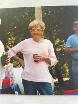
Audrey Don Faler Hahn
| Birth | : | 6 Dec 1936 Lawrence, Douglas County, Kansas, USA |
| Death | : | 11 Jul 2021 Lawrence, Douglas County, Kansas, USA |
| Burial | : | Oak Hill Cemetery, Lawrence, Douglas County, USA |
| Coordinate | : | 38.9589005, -95.2118988 |
| Plot | : | Section 18 |
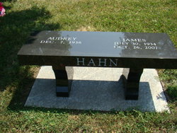
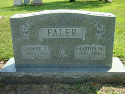
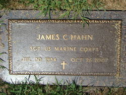
| Description | : | Married James C. Hahn in Bentonville, Ar. on Aug. 30, 1952. ∼Services for Audrey Don Hahn, 84, Lawrence, will be Monday, July 19, 2021 at 10:00 a.m. at Oak Hill Cemetery, Lawrence, Kansas. Mrs. Hahn died Sunday, July 11, 2021 at her home. She was born December 7, 1936, in Lawrence, the daughter of George Thomas Faler and Martha May Toyne. She graduated from Liberty Memorial High School in 1954. Audrey married James Conrad Hahn in 1952, he died in 2007. Audrey loved golfing, working in the yard, gathering with family, fast... Read More |
frequently asked questions (FAQ):
-
Where is Audrey Don Faler Hahn's memorial?
Audrey Don Faler Hahn's memorial is located at: Oak Hill Cemetery, Lawrence, Douglas County, USA.
-
When did Audrey Don Faler Hahn death?
Audrey Don Faler Hahn death on 11 Jul 2021 in Lawrence, Douglas County, Kansas, USA
-
Where are the coordinates of the Audrey Don Faler Hahn's memorial?
Latitude: 38.9589005
Longitude: -95.2118988
Family Members:
Parent

Spouse
Flowers:


Nearby Cemetories:
1. Oak Hill Cemetery
Lawrence, Douglas County, USA
Coordinate: 38.9589005, -95.2118988
2. Mount Calvary Catholic Cemetery
Lawrence, Douglas County, USA
Coordinate: 38.9580002, -95.2139969
3. Memorial Park Cemetery
Lawrence, Douglas County, USA
Coordinate: 38.9552994, -95.2153015
4. Trinity Episcopal Church Columbarium
Lawrence, Douglas County, USA
Coordinate: 38.9653893, -95.2373886
5. Saint Johns Catholic Cemetery
Douglas County, USA
Coordinate: 38.9437900, -95.1919600
6. Dyche Hall Natural History Museum
Lawrence, Douglas County, USA
Coordinate: 38.9584800, -95.2434800
7. Franklin Cemetery
Douglas County, USA
Coordinate: 38.9437523, -95.1869431
8. Haskell Cemetery
Lawrence, Douglas County, USA
Coordinate: 38.9353790, -95.2284241
9. Pioneer Cemetery
Lawrence, Douglas County, USA
Coordinate: 38.9528008, -95.2611008
10. First Presbyterian Church Memorial Garden
Lawrence, Douglas County, USA
Coordinate: 38.9414900, -95.2641600
11. Maple Grove Cemetery
Lawrence, Douglas County, USA
Coordinate: 39.0018997, -95.2316971
12. County Poor Farm Cemetery
Douglas County, USA
Coordinate: 38.9119400, -95.2214600
13. Adams Cemetery
Douglas County, USA
Coordinate: 38.9955400, -95.2509100
14. Kennedy Cemetery
Douglas County, USA
Coordinate: 38.9112900, -95.2269200
15. Davis Cemetery
Lawrence, Douglas County, USA
Coordinate: 38.9722500, -95.2831100
16. Blue Mound Cemetery
Lawrence, Douglas County, USA
Coordinate: 38.9046600, -95.1865400
17. Marshall Cemetery
Douglas County, USA
Coordinate: 38.9040800, -95.2446700
18. Dutton Cemetery
Douglas County, USA
Coordinate: 38.8989800, -95.2790600
19. Luckan Family Cemetery
Fall Leaf, Leavenworth County, USA
Coordinate: 38.9808500, -95.1128000
20. Cemetery Beni Israel
Eudora, Douglas County, USA
Coordinate: 38.9280128, -95.1122208
21. Southwest City Cemetery
Eudora, Douglas County, USA
Coordinate: 38.9334800, -95.1070300
22. Lyon Family Cemetery
Lawrence, Douglas County, USA
Coordinate: 38.9877440, -95.3166530
23. Corpus Christi Catholic Church Columbarium
Lawrence, Douglas County, USA
Coordinate: 38.9572250, -95.3238450
24. Richland Cemetery
Lawrence, Douglas County, USA
Coordinate: 38.8768997, -95.2630997