
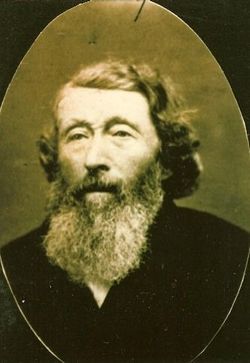
| Birth | : | 15 Feb 1862 Garnavillo, Clayton County, Iowa, USA |
| Death | : | 6 Nov 1929 Volga, Clayton County, Iowa, USA |
| Burial | : | Garnavillo Cemetery, Garnavillo, Clayton County, USA |
| Coordinate | : | 42.8660300, -91.2390100 |
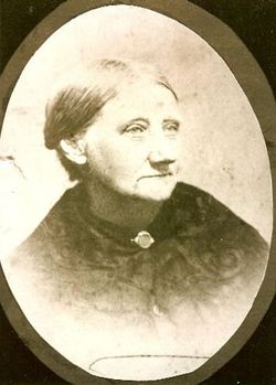
| Description | : | Thursday, 14 November 1929, Elkader, IA, Clayton County Register, p4, c6: August Carl Abel, son of Mr. and Mrs. Henry Abel, was born in Garnavillo, Iowa, on February 15, 1862 and died at the home of his son Wayne, near Volga City, Iowa, on Wednesday, November 6th, 1929 shortly before the noon hour, at the age of 67 years, eight months, and 21 days. On May 1, 1898, he was married in Elkader to Mamie Moon. For a number of years he made his home with his son Wayne and family, first on a farm near Motor, and... Read More |
frequently asked questions (FAQ):
-
Where is August Carl Abel's memorial?
August Carl Abel's memorial is located at: Garnavillo Cemetery, Garnavillo, Clayton County, USA.
-
When did August Carl Abel death?
August Carl Abel death on 6 Nov 1929 in Volga, Clayton County, Iowa, USA
-
Where are the coordinates of the August Carl Abel's memorial?
Latitude: 42.8660300
Longitude: -91.2390100
Family Members:
Parent
Spouse
Siblings
Children

Flowers:


Nearby Cemetories:
1. Garnavillo Cemetery
Garnavillo, Clayton County, USA
Coordinate: 42.8660300, -91.2390100
2. Garnavillo Community Cemetery
Garnavillo, Clayton County, USA
Coordinate: 42.8656000, -91.2422100
3. Saint Joseph Cemetery
Garnavillo, Clayton County, USA
Coordinate: 42.8628006, -91.2502975
4. McClelland Cemetery
Garnavillo, Clayton County, USA
Coordinate: 42.8249879, -91.2084641
5. Pioneer Rock Cemetery
Ceres, Clayton County, USA
Coordinate: 42.8230591, -91.1863937
6. Clayton Center Cemetery
Clayton Center, Clayton County, USA
Coordinate: 42.8841705, -91.3225021
7. Zion Lutheran Cemetery
Clayton Center, Clayton County, USA
Coordinate: 42.8841705, -91.3249969
8. Clayton Cemetery
Clayton, Clayton County, USA
Coordinate: 42.9043999, -91.1641998
9. Tangeman Family Cemetery
Garnavillo, Clayton County, USA
Coordinate: 42.8580000, -91.1420000
10. Saint Michael Cemetery
Clayton County, USA
Coordinate: 42.8055992, -91.1802979
11. County Home Cemetery
Clayton Center, Clayton County, USA
Coordinate: 42.8916702, -91.3499985
12. Borcherding Cemetery
Jefferson Township, Clayton County, USA
Coordinate: 42.8182983, -91.1414032
13. Krumm Cemetery
Garber, Clayton County, USA
Coordinate: 42.7913760, -91.3023559
14. Colony Catholic Cemetery (Defunct)
Read Township, Clayton County, USA
Coordinate: 42.8830000, -91.3580000
15. National Cemetery
National, Clayton County, USA
Coordinate: 42.9536018, -91.2902985
16. Harford Cemetery
Wyalusing, Grant County, USA
Coordinate: 42.9401000, -91.1401800
17. Storck Cemetery
Guttenberg, Clayton County, USA
Coordinate: 42.7694335, -91.1834638
18. Saint Paula Cemetery
Osterdock, Clayton County, USA
Coordinate: 42.7635994, -91.1992035
19. Norwegian Church Cemetery
McGregor, Clayton County, USA
Coordinate: 42.9644400, -91.1764100
20. Meenan Cemetery
Communia, Clayton County, USA
Coordinate: 42.7999862, -91.3584693
21. Old Garber Cemetery
Garber, Clayton County, USA
Coordinate: 42.7560005, -91.2580032
22. Bagley Cemetery
Bagley, Grant County, USA
Coordinate: 42.9019012, -91.0907974
23. First Evangelical Lutheran Church Cemetery
McGregor, Clayton County, USA
Coordinate: 42.9718000, -91.1760000
24. Elkader Cemetery
Elkader, Clayton County, USA
Coordinate: 42.8541718, -91.4000015