

Austin Puet Gillenwater
| Birth | : | 24 May 1834 Iowa, USA |
| Death | : | 6 Oct 1908 Washington, USA |
| Burial | : | Chesaw Cemetery, Okanogan County, USA |
| Coordinate | : | 48.9299900, -119.0541800 |
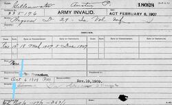
| Description | : | Civil War: Company D, 29th Iowa Infantry A. J. Gillnuatter (sic, Gillenwater), age 26 years, was enumerated July 6, 1860, at Quincy, Adams County, Iowa, with Jane Gillnuatter 26, Alsina Gillnuatter 4, Josephine Gillnuatter 2. His surname is also found spelled as Gillenwaters. Austin P. Gillenwater, age 28 years, whose residence was Quincy, Iowa, enlisted August 13 and mustered-in as Wagoner, Company D, 29th Iowa Infantry, December 1, 1862. Wagoner Gillenwater mustered-out at Greenville, Louisiana, May 31, 1865. Austin P. Gillenwater 38 years was enumerated at Quincy, Adams County, Iowa, June 8, 1870, with Jane Gillenwater 38,... Read More |
frequently asked questions (FAQ):
-
Where is Austin Puet Gillenwater's memorial?
Austin Puet Gillenwater's memorial is located at: Chesaw Cemetery, Okanogan County, USA.
-
When did Austin Puet Gillenwater death?
Austin Puet Gillenwater death on 6 Oct 1908 in Washington, USA
-
Where are the coordinates of the Austin Puet Gillenwater's memorial?
Latitude: 48.9299900
Longitude: -119.0541800
Family Members:
Spouse
Children

Flowers:


Nearby Cemetories:
1. Chesaw Cemetery
Okanogan County, USA
Coordinate: 48.9299900, -119.0541800
2. Thorp Cemetery
Chesaw, Okanogan County, USA
Coordinate: 48.9549900, -119.0316700
3. Kipling Cemetery
Okanogan County, USA
Coordinate: 48.9080500, -119.1652900
4. Molson Cemetery
Molson, Okanogan County, USA
Coordinate: 48.9657000, -119.2105000
5. Bridesville Cemetery
Bridesville, Kootenay Boundary Regional District, Canada
Coordinate: 49.0370800, -119.1372300
6. Immanuel Lutheran Cemetery
Havillah, Okanogan County, USA
Coordinate: 48.8305500, -119.2033500
7. Sidley-Lawless Cemetery
Sidley, Kootenay Boundary Regional District, Canada
Coordinate: 49.0153330, -119.2234330
8. Thomason Ranch Graves
Okanogan County, USA
Coordinate: 48.7757200, -118.9821900
9. Eagle Cliff Cemetery
Toroda, Ferry County, USA
Coordinate: 48.9404375, -118.7946296
10. Wauconda Cemetery
Wauconda, Okanogan County, USA
Coordinate: 48.7408300, -119.0597300
11. Ranald McDonald Cemetery
Toroda, Ferry County, USA
Coordinate: 48.9472094, -118.7617135
12. Village of Midway Cemetery
Midway, Kootenay Boundary Regional District, Canada
Coordinate: 49.0082520, -118.7609490
13. Mountain View Memorial Cemetery
Ellisforde, Okanogan County, USA
Coordinate: 48.8328300, -119.4011300
14. Oroville Riverview Cemetery
Oroville, Okanogan County, USA
Coordinate: 48.9202700, -119.4458500
15. Old Riverview Cemetery
Oroville, Okanogan County, USA
Coordinate: 48.9177800, -119.4466700
16. Old Oroville Cemetery
Okanogan County, USA
Coordinate: 48.8913360, -119.4456230
17. Ellisforde Mission Cemetery
Ellisforde, Okanogan County, USA
Coordinate: 48.7908300, -119.3972300
18. Curlew Indian Cemetery
Curlew, Ferry County, USA
Coordinate: 48.8811145, -118.6002982
19. Merritt Pioneer Grave
Curlew, Ferry County, USA
Coordinate: 48.8745300, -118.6020000
20. Curlew City Cemetery
Curlew, Ferry County, USA
Coordinate: 48.8734163, -118.6010599
21. Anglin Cemetery
Okanogan County, USA
Coordinate: 48.6627700, -119.2783400
22. Golden Cemetery
Okanogan County, USA
Coordinate: 48.9014015, -119.5203018
23. Greenwood Cemetery
Greenwood, Kootenay Boundary Regional District, Canada
Coordinate: 49.1250200, -118.6836000
24. Somday Family Cemetery
Malo, Ferry County, USA
Coordinate: 48.8290000, -118.5990000