
| Memorials | : | 1 |
| Location | : | Malo, Ferry County, USA |
| Coordinate | : | 48.8290000, -118.5990000 |
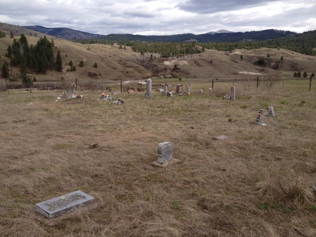
| Description | : | Somday Family Cemetery Malo, Ferry County, Washington Lat: 48°49'44"N, Lon: 118°35'56"W To reach cemetery from Malo store, drive north on Hwy 21 to the Empire Creek Rd, here you turn left and continue taking the first left. This will be on the Somday farm. It might be advisable to stop at one of the homes for permission to continue on to the cemetery. This is owned and maintained by the Somday family and contains many burial sites which have no marker, and only are known by family, most of which are now deceased also. |
frequently asked questions (FAQ):
-
Where is Somday Family Cemetery?
Somday Family Cemetery is located at Malo, Ferry County ,Washington ,USA.
-
Somday Family Cemetery cemetery's updated grave count on graveviews.com?
1 memorials
-
Where are the coordinates of the Somday Family Cemetery?
Latitude: 48.8290000
Longitude: -118.5990000
Nearby Cemetories:
1. Curlew City Cemetery
Curlew, Ferry County, USA
Coordinate: 48.8734163, -118.6010599
2. Merritt Pioneer Grave
Curlew, Ferry County, USA
Coordinate: 48.8745300, -118.6020000
3. Curlew Indian Cemetery
Curlew, Ferry County, USA
Coordinate: 48.8811145, -118.6002982
4. Ranald McDonald Cemetery
Toroda, Ferry County, USA
Coordinate: 48.9472094, -118.7617135
5. Danville Cemetery
Ferry County, USA
Coordinate: 48.9885640, -118.5151702
6. Eagle Cliff Cemetery
Toroda, Ferry County, USA
Coordinate: 48.9404375, -118.7946296
7. Republic Cemetery
Republic, Ferry County, USA
Coordinate: 48.6555363, -118.7218022
8. USCC Sion Cemetery
Grand Forks, Kootenay Boundary Regional District, Canada
Coordinate: 49.0159500, -118.4964300
9. Village of Midway Cemetery
Midway, Kootenay Boundary Regional District, Canada
Coordinate: 49.0082520, -118.7609490
10. Evergreen Cemetery
Grand Forks, Kootenay Boundary Regional District, Canada
Coordinate: 49.0243650, -118.4520650
11. Outlook Khristovoye Doukhobor Cemetery
Grand Forks, Kootenay Boundary Regional District, Canada
Coordinate: 49.0402930, -118.4835600
12. Gilpin Cemetery # 1
Gilpin, Kootenay Boundary Regional District, Canada
Coordinate: 49.0090920, -118.3181980
13. Thomason Ranch Graves
Okanogan County, USA
Coordinate: 48.7757200, -118.9821900
14. Orient Cemetery
Orient, Ferry County, USA
Coordinate: 48.8578987, -118.2032013
15. Gilpin Cemetery # 2
Gilpin, Kootenay Boundary Regional District, Canada
Coordinate: 49.0084500, -118.3073490
16. Phoenix Cemetery
Greenwood, Kootenay Boundary Regional District, Canada
Coordinate: 49.1019000, -118.6285500
17. Laurier Cemetery
Ferry County, USA
Coordinate: 48.9855500, -118.2189000
18. Greenwood Cemetery
Greenwood, Kootenay Boundary Regional District, Canada
Coordinate: 49.1250200, -118.6836000
19. Cascade Cemetery
Cascade, Kootenay Boundary Regional District, Canada
Coordinate: 49.0188990, -118.2247300
20. Thorp Cemetery
Chesaw, Okanogan County, USA
Coordinate: 48.9549900, -119.0316700
21. Kelly Hill Cemetery
Stevens County, USA
Coordinate: 48.8130989, -118.1268997
22. Chesaw Cemetery
Okanogan County, USA
Coordinate: 48.9299900, -119.0541800
23. Wauconda Cemetery
Wauconda, Okanogan County, USA
Coordinate: 48.7408300, -119.0597300
24. Pia Mission Cemetery
Stevens County, USA
Coordinate: 48.7960700, -118.1097300