
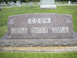

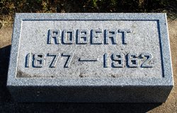
Beancy M Walsh Coon
| Birth | : | 22 Jan 1887 Butler County, Iowa, USA |
| Death | : | 21 Aug 1973 Waverly, Bremer County, Iowa, USA |
| Burial | : | Kingston Cemetery, Portsmouth, Portsmouth Unitary Authority, England |
| Coordinate | : | 50.8031440, -1.0683260 |
| Plot | : | R 3 |
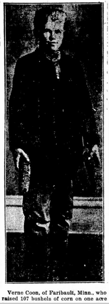
| Description | : | The Clarksville Star -- August 23, 1973 -- Mrs. Beancy Coon, 86, died Tuesday at Waverly Hospital. Mrs. Beancy Coon, 86, a long time resident of the Clarksville community died Tuesday night, August 21, 1973 at the hospital in Waverly. Mrs. Coon had been in failing health for several weeks. Funeral Services will be held Friday afternoon at 1:00 o'clock at the Community Church with Rev. Reuben J. Topp officiating. A Rebekah Lodge service will be held Thursday evening at 7:30 at the Schwartz Funeral Home. A daughter of William and Ida Shadbolt Walsh, she was born in Butler Township... Read More |
frequently asked questions (FAQ):
-
Where is Beancy M Walsh Coon's memorial?
Beancy M Walsh Coon's memorial is located at: Kingston Cemetery, Portsmouth, Portsmouth Unitary Authority, England.
-
When did Beancy M Walsh Coon death?
Beancy M Walsh Coon death on 21 Aug 1973 in Waverly, Bremer County, Iowa, USA
-
Where are the coordinates of the Beancy M Walsh Coon's memorial?
Latitude: 50.8031440
Longitude: -1.0683260
Family Members:
Parent
Spouse

Siblings
Children
Flowers:


Nearby Cemetories:
1. Kingston Cemetery
Portsmouth, Portsmouth Unitary Authority, England
Coordinate: 50.8031440, -1.0683260
2. St. Mary's Churchyard
Portsea, Portsmouth Unitary Authority, England
Coordinate: 50.8035350, -1.0763490
3. Milton Cemetery
Portsmouth, Portsmouth Unitary Authority, England
Coordinate: 50.7988700, -1.0608030
4. St James Churchyard
Eastney, Portsmouth Unitary Authority, England
Coordinate: 50.7940650, -1.0581150
5. Mile End Cemetery
Portsea, Portsmouth Unitary Authority, England
Coordinate: 50.8108900, -1.0876400
6. Old Jewish Cemetery
Portsmouth, Portsmouth Unitary Authority, England
Coordinate: 50.7887000, -1.0738800
7. Highland Road Cemetery
Portsmouth, Portsmouth Unitary Authority, England
Coordinate: 50.7860500, -1.0671790
8. HMS Victoria Monument
Portsmouth, Portsmouth Unitary Authority, England
Coordinate: 50.7997200, -1.0950800
9. Portsmouth Unitarian Church
Portsmouth, Portsmouth Unitary Authority, England
Coordinate: 50.7915640, -1.1011840
10. Portsmouth Cathedral Churchyard
Portsmouth, Portsmouth Unitary Authority, England
Coordinate: 50.7904650, -1.1043720
11. HMS Victory Ship
Portsmouth, Portsmouth Unitary Authority, England
Coordinate: 50.8017290, -1.1095590
12. Royal Garrison Church Churchyard
Plymouth, Plymouth Unitary Authority, England
Coordinate: 50.7889690, -1.1039650
13. Royal Garrison Churchyard
Portsmouth, Portsmouth Unitary Authority, England
Coordinate: 50.7890180, -1.1040520
14. Portsmouth Naval Memorial
Portsmouth, Portsmouth Unitary Authority, England
Coordinate: 50.7824440, -1.0957720
15. Holy Trinity Churchyard
Gosport, Gosport Borough, England
Coordinate: 50.7930600, -1.1207620
16. St Peter and St Paul Churchyard
Wymering, Portsmouth Unitary Authority, England
Coordinate: 50.8457490, -1.0777170
17. St. Mary's Churchyard
Portchester, Fareham Borough, England
Coordinate: 50.8366280, -1.1134270
18. St John the Evangelist Churchyard
Gosport, Gosport Borough, England
Coordinate: 50.7995600, -1.1397800
19. Clayhall Naval Cemetery
Gosport, Gosport Borough, England
Coordinate: 50.7833862, -1.1373420
20. Turkish Naval Cemetery
Gosport, Gosport Borough, England
Coordinate: 50.7840710, -1.1383980
21. Roman Grove Cemetery
Portchester, Fareham Borough, England
Coordinate: 50.8384600, -1.1206200
22. St. Andrew's Churchyard
Farlington, Portsmouth Unitary Authority, England
Coordinate: 50.8477200, -1.0274510
23. St Thomas the Apostle Churchyard
Gosport, Gosport Borough, England
Coordinate: 50.8137570, -1.1484570
24. St. Mark's Churchyard
Alverstoke, Gosport Borough, England
Coordinate: 50.7826800, -1.1436100