
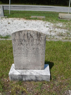
Belton O'Hara Kelley
| Birth | : | 16 Apr 1876 Greenville County, South Carolina, USA |
| Death | : | 26 Jan 1937 Landrum, Spartanburg County, South Carolina, USA |
| Burial | : | Deloraine General Cemetery, Deloraine, Meander Valley Council, Australia |
| Coordinate | : | -41.5077836, 146.6302915 |
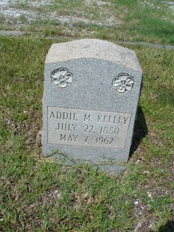
| Description | : | Son of John Baxter & Elizabeth Stewart Kelley ____________________________ Source: Greenville News, p 13 Date: 27 Jan 1937 Belton Kelly Landrum, Jan. 26 -- Belton Kelly, 60, died at his residence here this afternoon at 1:15 o'clock following an illness of two weeks. He had made his home here a number of years and had been a member of Ingleside Baptist church. He was the son of the late John and Mrs. Stewart Kelly. He is survived by his wife, Mrs. Addie Kelly; two daughters, Mrs. L.E. Hall and Miss Jessie Kelly, three grandchildren, his stepmother, Mrs. John Kelly; one brother,... Read More |
frequently asked questions (FAQ):
-
Where is Belton O'Hara Kelley's memorial?
Belton O'Hara Kelley's memorial is located at: Deloraine General Cemetery, Deloraine, Meander Valley Council, Australia.
-
When did Belton O'Hara Kelley death?
Belton O'Hara Kelley death on 26 Jan 1937 in Landrum, Spartanburg County, South Carolina, USA
-
Where are the coordinates of the Belton O'Hara Kelley's memorial?
Latitude: -41.5077836
Longitude: 146.6302915
Family Members:
Parent

Spouse
Siblings
Children
Flowers:


Nearby Cemetories:
1. Deloraine General Cemetery
Deloraine, Meander Valley Council, Australia
Coordinate: -41.5077836, 146.6302915
2. Saint Mark's Anglican Cemetery
Deloraine, Meander Valley Council, Australia
Coordinate: -41.5250850, 146.6600750
3. Chudleigh Presbyterian Cemetery
Chudleigh, Meander Valley Council, Australia
Coordinate: -41.5632480, 146.4863430
4. Chudleigh Cemetery
Chudleigh, Meander Valley Council, Australia
Coordinate: -41.5532600, 146.4788000
5. Meander Cemetery
Meander, Meander Valley Council, Australia
Coordinate: -41.6493140, 146.6173550
6. St. Michael and All Angels Anglican Cemetery
Kimberley, Meander Valley Council, Australia
Coordinate: -41.4032830, 146.4960360
7. Westbury General Cemetery
Westbury, Meander Valley Council, Australia
Coordinate: -41.5319850, 146.8259020
8. Westbury Uniting Church Cemetery
Westbury, Meander Valley Council, Australia
Coordinate: -41.5316580, 146.8318780
9. Culzean Cemetery
Westbury, Meander Valley Council, Australia
Coordinate: -41.5212380, 146.8339060
10. Westbury Pioneer Catholic Cemetery
Westbury, Meander Valley Council, Australia
Coordinate: -41.5333340, 146.8393990
11. Western Creek Cemetery
Meander Valley Council, Australia
Coordinate: -41.6394750, 146.4960280
12. Mole Creek General and Lawn Cemetery
Mole Creek, Meander Valley Council, Australia
Coordinate: -41.5703200, 146.4055750
13. Hagley Methodist-Uniting Cemetery
Hagley, Meander Valley Council, Australia
Coordinate: -41.5258094, 146.8881433
14. Frankford Cemetery
Frankford, West Tamar Council, Australia
Coordinate: -41.3611110, 146.8022220
15. Hagley Presbyterian Cemetery
Hagley, Meander Valley Council, Australia
Coordinate: -41.5255610, 146.8975560
16. St. Mary's Anglican Church Cemetery
Hagley, Meander Valley Council, Australia
Coordinate: -41.5217840, 146.9104460
17. Railton Roman Catholic Cemetery
Railton, Kentish Council, Australia
Coordinate: -41.3542310, 146.4160170
18. Railton Methodist Cemetery
Railton, Kentish Council, Australia
Coordinate: -41.3517810, 146.4169420
19. St. James Roman Catholic Cemetery
Railton, Kentish Council, Australia
Coordinate: -41.3569000, 146.4103680
20. St John’s Anglican Church Cemetery
Railton, Kentish Council, Australia
Coordinate: -41.3521240, 146.4130000
21. Sassafras Baptist Church Cemetery
Sassafras East, Latrobe Council, Australia
Coordinate: -41.2892740, 146.5059210
22. Whitemore Methodist-Uniting Cemetery
Whitemore, Meander Valley Council, Australia
Coordinate: -41.5810490, 146.9325240
23. Sassafras Uniting Church Cemetery
Sassafras, Latrobe Council, Australia
Coordinate: -41.2841730, 146.5071220
24. St. Canice Catholic Cemetery
Glengarry, West Tamar Council, Australia
Coordinate: -41.3350250, 146.8701150