
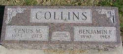
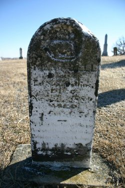
Benjamin Franklin Collins
| Birth | : | 28 Aug 1890 Van Wert, Decatur County, Iowa, USA |
| Death | : | 5 Feb 1968 Burlington, Des Moines County, Iowa, USA |
| Burial | : | Visitation Catholic Cemetery, Stacyville, Mitchell County, USA |
| Coordinate | : | 43.4430618, -92.7813873 |
| Plot | : | Section 2 |
frequently asked questions (FAQ):
-
Where is Benjamin Franklin Collins's memorial?
Benjamin Franklin Collins's memorial is located at: Visitation Catholic Cemetery, Stacyville, Mitchell County, USA.
-
When did Benjamin Franklin Collins death?
Benjamin Franklin Collins death on 5 Feb 1968 in Burlington, Des Moines County, Iowa, USA
-
Where are the coordinates of the Benjamin Franklin Collins's memorial?
Latitude: 43.4430618
Longitude: -92.7813873
Family Members:
Parent
Spouse

Siblings

Children
Flowers:


Nearby Cemetories:
1. Stacyville Cemetery
Stacyville, Mitchell County, USA
Coordinate: 43.4294014, -92.7908020
2. Union Presbyterian Cemetery
Stacyville, Mitchell County, USA
Coordinate: 43.4797211, -92.8088913
3. Union Township Cemetery
Toeterville, Mitchell County, USA
Coordinate: 43.4578018, -92.8491974
4. Sacred Heart Cemetery
Meyer, Mitchell County, USA
Coordinate: 43.4583282, -92.7011108
5. Saint Johns Cemetery
Johnsburg, Mower County, USA
Coordinate: 43.5055618, -92.7688904
6. Liberty Cemetery
Little Cedar, Mitchell County, USA
Coordinate: 43.3856010, -92.7230988
7. Saint Peter Cemetery
Toeterville, Mitchell County, USA
Coordinate: 43.4402809, -92.8897171
8. Robbins Cemetery
David (historical), Mitchell County, USA
Coordinate: 43.4150009, -92.6718979
9. Six Mile Grove Cemetery
Lyle, Mower County, USA
Coordinate: 43.5069389, -92.8836136
10. Saint Patricks Church Cemetery
McIntire, Mitchell County, USA
Coordinate: 43.4771996, -92.6508026
11. Saint Ansgar Cemetery
Saint Ansgar, Mitchell County, USA
Coordinate: 43.3777809, -92.9094391
12. Rustad Cemetery
Otranto, Mitchell County, USA
Coordinate: 43.4585991, -92.9400024
13. First Lutheran Cemetery
Saint Ansgar, Mitchell County, USA
Coordinate: 43.3841705, -92.9194412
14. Mona Cemetery
Mona, Mitchell County, USA
Coordinate: 43.4824982, -92.9402771
15. McKinley Cemetery
Saint Ansgar, Mitchell County, USA
Coordinate: 43.3906400, -92.9368300
16. Pleasant Hill Cemetery
Mona, Mitchell County, USA
Coordinate: 43.4768982, -92.9467010
17. Immanuel Lutheran Cemetery
Saint Ansgar, Mitchell County, USA
Coordinate: 43.3717003, -92.9257965
18. Sacred Heart Cemetery
Adams, Mower County, USA
Coordinate: 43.5635986, -92.7221985
19. Beaver Creek Cemetery
Brownville, Mitchell County, USA
Coordinate: 43.3397217, -92.6727829
20. Little Cedar Cemetery
Adams, Mower County, USA
Coordinate: 43.5736008, -92.7574997
21. Ogden Cemetery
Otranto, Mitchell County, USA
Coordinate: 43.4366989, -92.9681015
22. Blakestad Cemetery
Saint Ansgar, Mitchell County, USA
Coordinate: 43.3711014, -92.9400024
23. Riverview Cemetery
Saint Ansgar, Mitchell County, USA
Coordinate: 43.3430328, -92.9220200
24. Oak Grove Cemetery
Mitchell, Mitchell County, USA
Coordinate: 43.3156013, -92.8707962