
| Birth | : | 16 Mar 1851 Davis County, Iowa, USA |
| Death | : | 6 Sep 1929 Ottumwa, Wapello County, Iowa, USA |
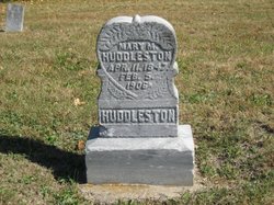
| Burial | : | Spring Hill Cemetery, Worcester County, USA |
| Coordinate | : | 38.1044006, -75.3961029 |
| Plot | : | 72~EDGE |
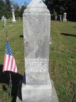
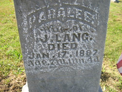
| Description | : | Benjamin Greenleaf Lang married Mary Elizabeth Tharp on 16 April 1876 in Davis co., Iowa or Fountain co., Indiana.... They were the parents of Otis, Cora, Viola/Ola, Bertha, Ethel Louise, Lena, and Lella Elizabeth Lang. Daughter, Ethel - Memorial# 66934144 |
frequently asked questions (FAQ):
-
Where is Benjamin Greenleaf “Green” Lang's memorial?
Benjamin Greenleaf “Green” Lang's memorial is located at: Spring Hill Cemetery, Worcester County, USA.
-
When did Benjamin Greenleaf “Green” Lang death?
Benjamin Greenleaf “Green” Lang death on 6 Sep 1929 in Ottumwa, Wapello County, Iowa, USA
-
Where are the coordinates of the Benjamin Greenleaf “Green” Lang's memorial?
Latitude: 38.1044006
Longitude: -75.3961029
Family Members:
Parent
Spouse

Siblings
Children
Flowers:


Nearby Cemetories:
1. Spring Hill Cemetery
Worcester County, USA
Coordinate: 38.1044006, -75.3961029
2. Coolspring United Methodist Church Cemetery
Girdletree, Worcester County, USA
Coordinate: 38.1124992, -75.3908005
3. Nelson-Stevenson Cemetery
Snow Hill, Worcester County, USA
Coordinate: 38.1436510, -75.4074846
4. Saint Lukes Cemetery
Worcester County, USA
Coordinate: 38.0960999, -75.4531021
5. Sandy Hill Cemetery
Stockton, Worcester County, USA
Coordinate: 38.0561660, -75.4151950
6. Church Street Cemetery
Stockton, Worcester County, USA
Coordinate: 38.0561904, -75.4164793
7. Church Street Cemetery
Worcester County, USA
Coordinate: 38.0560989, -75.4169006
8. Gunby Presbyterian Church Cemetery
Stockton, Worcester County, USA
Coordinate: 38.0541992, -75.4085999
9. Betheden Cemetery
Worcester County, USA
Coordinate: 38.1114006, -75.4608002
10. Wesley Cemetery
Worcester County, USA
Coordinate: 38.0546989, -75.4135971
11. Home Beneficial Cemetery
Stockton, Worcester County, USA
Coordinate: 38.0542500, -75.4175827
12. Beth Eden - Tilghman Hill Cemetery
Worcester County, USA
Coordinate: 38.1150017, -75.4621964
13. Portersville Cemetery
Stockton, Worcester County, USA
Coordinate: 38.0480995, -75.3899994
14. Hancock Cemetery
Worcester County, USA
Coordinate: 38.0783005, -75.4599991
15. Shiloh Cemetery
Worcester County, USA
Coordinate: 38.0974998, -75.4760971
16. Mount Zion Cemetery
Snow Hill, Worcester County, USA
Coordinate: 38.1706009, -75.4036026
17. Bates Methodist Church Cemetery
Snow Hill, Worcester County, USA
Coordinate: 38.1708600, -75.3991500
18. Old School Baptist Church Cemetery
Snow Hill, Worcester County, USA
Coordinate: 38.1748410, -75.3910290
19. Whatcoat United Methodist Cemetery
Snow Hill, Worcester County, USA
Coordinate: 38.1751500, -75.3904100
20. All Hallows Cemetery
Snow Hill, Worcester County, USA
Coordinate: 38.1755981, -75.3946991
21. Makemie Memorial Cemetery
Snow Hill, Worcester County, USA
Coordinate: 38.1755981, -75.3938980
22. Old Shiloh Cemetery
Pocomoke City, Worcester County, USA
Coordinate: 38.1044960, -75.4878110
23. Old Shiloh Cemetery
Worcester County, USA
Coordinate: 38.1044006, -75.4882965
24. Waters Cemetery
Mount Vernon, Somerset County, USA
Coordinate: 38.1600000, -75.4600000