

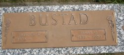
Bernice Helen “Bernie” Slikkerveer Bustad
| Birth | : | 7 Jul 1923 Akron, Plymouth County, Iowa, USA |
| Death | : | 19 Mar 2018 |
| Burial | : | Great Harwood Cemetery, Great Harwood, Hyndburn Borough, England |
| Coordinate | : | 53.7796190, -2.4091680 |
| Description | : | Bernice Helen Bustad, 94, passed away in Des Moines on March 19, 2018. Visitation will be Monday, April 2, 2018, from 11 am to 12 pm at the Woodward United Methodist Church. A private burial will take place at Woodward Cemetery. She is preceded in death by her husband, James; sons, Mark and James; and daughter in law, Linda. |
frequently asked questions (FAQ):
-
Where is Bernice Helen “Bernie” Slikkerveer Bustad's memorial?
Bernice Helen “Bernie” Slikkerveer Bustad's memorial is located at: Great Harwood Cemetery, Great Harwood, Hyndburn Borough, England.
-
When did Bernice Helen “Bernie” Slikkerveer Bustad death?
Bernice Helen “Bernie” Slikkerveer Bustad death on 19 Mar 2018 in
-
Where are the coordinates of the Bernice Helen “Bernie” Slikkerveer Bustad's memorial?
Latitude: 53.7796190
Longitude: -2.4091680
Family Members:
Parent
Spouse
Siblings
Children

Flowers:


Nearby Cemetories:
1. Great Harwood Cemetery
Great Harwood, Hyndburn Borough, England
Coordinate: 53.7796190, -2.4091680
2. Our Lady and Saint Hubert
Great Harwood, Hyndburn Borough, England
Coordinate: 53.7851070, -2.4009760
3. St. Bartholomew's Churchyard
Great Harwood, Hyndburn Borough, England
Coordinate: 53.7900670, -2.4055460
4. All Saints Churchyard
Clayton-le-Moors, Hyndburn Borough, England
Coordinate: 53.7738520, -2.3881690
5. Barnes Square Weslyan Methodist Churchyard
Clayton-le-Moors, Hyndburn Borough, England
Coordinate: 53.7744350, -2.3853800
6. St Marys Burial Ground
Clayton-le-Moors, Hyndburn Borough, England
Coordinate: 53.7792778, -2.3705871
7. Church and Clayton-le-Moors Cemetery
Accrington, Hyndburn Borough, England
Coordinate: 53.7630200, -2.3804820
8. St James Churchyard
Church, Hyndburn Borough, England
Coordinate: 53.7574640, -2.3942660
9. St. James' Parish Church
Accrington, Hyndburn Borough, England
Coordinate: 53.7519900, -2.3652600
10. Accrington Cemetery and Crematorium
Accrington, Hyndburn Borough, England
Coordinate: 53.7623787, -2.3508649
11. St James Church
Altham, Hyndburn Borough, England
Coordinate: 53.7928940, -2.3465250
12. Blackburn Cemetery
Blackburn, Blackburn with Darwen Unitary Authority, England
Coordinate: 53.7662430, -2.4726050
13. Saint Mary and All Saints Churchyard
Whalley, Ribble Valley Borough, England
Coordinate: 53.8211890, -2.4078080
14. New Lane Baptist Chapel Chapelyard
Oswaldwistle, Hyndburn Borough, England
Coordinate: 53.7381100, -2.4049500
15. St. John's Churchyard
Read, Ribble Valley Borough, England
Coordinate: 53.8088800, -2.3585600
16. Christ Church Churchyard
Accrington, Hyndburn Borough, England
Coordinate: 53.7478560, -2.3605820
17. Immanuel Churchyard
Oswaldwistle, Hyndburn Borough, England
Coordinate: 53.7358300, -2.4056200
18. St Peter Churchyard
Salesbury, Ribble Valley Borough, England
Coordinate: 53.7915000, -2.4859100
19. St. Leonard Old Churchyard
Langho, Ribble Valley Borough, England
Coordinate: 53.8178590, -2.4552870
20. St Alban's Churchyard
Blackburn, Blackburn with Darwen Unitary Authority, England
Coordinate: 53.7530090, -2.4748540
21. Brockhall Hospital Cemetery
Brockhall Village, Ribble Valley Borough, England
Coordinate: 53.8186850, -2.4560220
22. Holy Trinity Church
Blackburn with Darwen Unitary Authority, England
Coordinate: 53.7511727, -2.4747178
23. Whalley, Wiswell and Barrow Cemetery
Whalley, Ribble Valley Borough, England
Coordinate: 53.8308490, -2.4057280
24. Mount St Presbyterian Chapelyard
Blackburn, Blackburn with Darwen Unitary Authority, England
Coordinate: 53.7478000, -2.4775000