
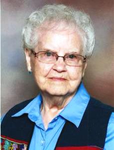
Bernita Schulte McMillin
| Birth | : | 19 Oct 1927 Clayton County, Iowa, USA |
| Death | : | 23 Nov 2014 La Crosse County, Wisconsin, USA |
| Burial | : | Garnavillo Community Cemetery, Garnavillo, Clayton County, USA |
| Coordinate | : | 42.8656000, -91.2422100 |
| Description | : | Bernita d/o Lawrence Henry Schulte 1892-1968 and Amanda L Werkamp 1895-1964/1990 Bernita McMillin, age 87, of Garnavillo, IA, formerly of Prairie du Chien Wis, passed away Sunday, November 23, 2014, at Gundersen Health System in La Crosse, WI. She was born in Reed Township in Clayton County Iowa. Bernita received her education locally and graduated from the McGregor High School. Shortly after school, Bernita was united in marriage with Delbert McMillin on October 19, 1945, at St. Paul Church in Garnavillo by Rev. Victor Hackbarth. For many years, Bernita farmed beside her husband while making a home and caring for children. Bernita is survived by... Read More |
frequently asked questions (FAQ):
-
Where is Bernita Schulte McMillin's memorial?
Bernita Schulte McMillin's memorial is located at: Garnavillo Community Cemetery, Garnavillo, Clayton County, USA.
-
When did Bernita Schulte McMillin death?
Bernita Schulte McMillin death on 23 Nov 2014 in La Crosse County, Wisconsin, USA
-
Where are the coordinates of the Bernita Schulte McMillin's memorial?
Latitude: 42.8656000
Longitude: -91.2422100
Family Members:
Parent

Spouse
Siblings
Children

Flowers:


Nearby Cemetories:
1. Garnavillo Community Cemetery
Garnavillo, Clayton County, USA
Coordinate: 42.8656000, -91.2422100
2. Garnavillo Cemetery
Garnavillo, Clayton County, USA
Coordinate: 42.8660300, -91.2390100
3. Saint Joseph Cemetery
Garnavillo, Clayton County, USA
Coordinate: 42.8628006, -91.2502975
4. McClelland Cemetery
Garnavillo, Clayton County, USA
Coordinate: 42.8249879, -91.2084641
5. Pioneer Rock Cemetery
Ceres, Clayton County, USA
Coordinate: 42.8230591, -91.1863937
6. Clayton Center Cemetery
Clayton Center, Clayton County, USA
Coordinate: 42.8841705, -91.3225021
7. Zion Lutheran Cemetery
Clayton Center, Clayton County, USA
Coordinate: 42.8841705, -91.3249969
8. Clayton Cemetery
Clayton, Clayton County, USA
Coordinate: 42.9043999, -91.1641998
9. Tangeman Family Cemetery
Garnavillo, Clayton County, USA
Coordinate: 42.8580000, -91.1420000
10. Saint Michael Cemetery
Clayton County, USA
Coordinate: 42.8055992, -91.1802979
11. County Home Cemetery
Clayton Center, Clayton County, USA
Coordinate: 42.8916702, -91.3499985
12. Krumm Cemetery
Garber, Clayton County, USA
Coordinate: 42.7913760, -91.3023559
13. Colony Catholic Cemetery (Defunct)
Read Township, Clayton County, USA
Coordinate: 42.8830000, -91.3580000
14. Borcherding Cemetery
Jefferson Township, Clayton County, USA
Coordinate: 42.8182983, -91.1414032
15. National Cemetery
National, Clayton County, USA
Coordinate: 42.9536018, -91.2902985
16. Storck Cemetery
Guttenberg, Clayton County, USA
Coordinate: 42.7694335, -91.1834638
17. Harford Cemetery
Wyalusing, Grant County, USA
Coordinate: 42.9401000, -91.1401800
18. Saint Paula Cemetery
Osterdock, Clayton County, USA
Coordinate: 42.7635994, -91.1992035
19. Meenan Cemetery
Communia, Clayton County, USA
Coordinate: 42.7999862, -91.3584693
20. Norwegian Church Cemetery
McGregor, Clayton County, USA
Coordinate: 42.9644400, -91.1764100
21. Old Garber Cemetery
Garber, Clayton County, USA
Coordinate: 42.7560005, -91.2580032
22. Elkader Cemetery
Elkader, Clayton County, USA
Coordinate: 42.8541718, -91.4000015
23. Bagley Cemetery
Bagley, Grant County, USA
Coordinate: 42.9019012, -91.0907974
24. First Evangelical Lutheran Church Cemetery
McGregor, Clayton County, USA
Coordinate: 42.9718000, -91.1760000