

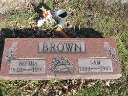
Bertha Mary Shure Brown
| Birth | : | 1 Dec 1901 Opolis, Crawford County, Kansas, USA |
| Death | : | 28 Oct 1990 Pittsburg, Crawford County, Kansas, USA |
| Burial | : | St Michael and All Angels Churchyard, Twerton, Bath and North East Somerset Unitary Authority, England |
| Coordinate | : | 51.3809000, -2.3981000 |
| Description | : | SUNDAY OCT. 28, 1990 PITTSBURG MORNING SUN BERTHA M. BROWN, 88, of 606 N. Smith, died at 2:30 a.m. Sunday, Oct. 28, 1990 at Beverly Nursing Home. She had been in ill health for one year, seriously ill and a patient in the nursing home for two months. She was born on Dec. 14, 1901 in Opolis to Gus and Hilda Laddames Shure. She had been an area resident for most of her life. She married Sam Brown on June 25, 1926 in Neosho, Mo. and he preceded her in death on Dec. 26, 1983. Mrs. Brown and her husband owned and operated the... Read More |
frequently asked questions (FAQ):
-
Where is Bertha Mary Shure Brown's memorial?
Bertha Mary Shure Brown's memorial is located at: St Michael and All Angels Churchyard, Twerton, Bath and North East Somerset Unitary Authority, England.
-
When did Bertha Mary Shure Brown death?
Bertha Mary Shure Brown death on 28 Oct 1990 in Pittsburg, Crawford County, Kansas, USA
-
Where are the coordinates of the Bertha Mary Shure Brown's memorial?
Latitude: 51.3809000
Longitude: -2.3981000
Family Members:
Spouse

Children
Flowers:


Nearby Cemetories:
1. St Michael and All Angels Churchyard
Twerton, Bath and North East Somerset Unitary Authority, England
Coordinate: 51.3809000, -2.3981000
2. Locksbrook Cemetery
Lower Weston, Bath and North East Somerset Unitary Authority, England
Coordinate: 51.3845180, -2.3850300
3. Twerton Cemetery
Twerton, Bath and North East Somerset Unitary Authority, England
Coordinate: 51.3802500, -2.3836220
4. Locksbrook St Saviour's Cemetery
Bath and North East Somerset Unitary Authority, England
Coordinate: 51.3867880, -2.3863380
5. Haycombe Cemetery and Crematorium
Bath, Bath and North East Somerset Unitary Authority, England
Coordinate: 51.3703430, -2.4014760
6. St. Michael's Cemetery
Bath, Bath and North East Somerset Unitary Authority, England
Coordinate: 51.3859700, -2.3814500
7. Moravian Burial Ground
Bath, Bath and North East Somerset Unitary Authority, England
Coordinate: 51.3894150, -2.3798150
8. All Saints Churchyard
Weston, Bath and North East Somerset Unitary Authority, England
Coordinate: 51.3956850, -2.3881320
9. St. James' Cemetery
Bath, Bath and North East Somerset Unitary Authority, England
Coordinate: 51.3802000, -2.3722200
10. Countess of Huntingdon's Chapel
Walcot, Bath and North East Somerset Unitary Authority, England
Coordinate: 51.3967020, -2.3907434
11. St Peter Churchyard
Englishcombe, Bath and North East Somerset Unitary Authority, England
Coordinate: 51.3640600, -2.4088700
12. Holy Trinity Churchyard
Newton St Loe, Bath and North East Somerset Unitary Authority, England
Coordinate: 51.3820470, -2.4311300
13. St Mary's Chapel, Queens Square
Bath, Bath and North East Somerset Unitary Authority, England
Coordinate: 51.3827790, -2.3649790
14. St Mary Magdalen Chapel
Widcombe, Bath and North East Somerset Unitary Authority, England
Coordinate: 51.3760486, -2.3643405
15. Bath General Hospital Burial Ground
Bath and North East Somerset Unitary Authority, England
Coordinate: 51.3824715, -2.3614742
16. St James Old Burial Ground
Bath, Bath and North East Somerset Unitary Authority, England
Coordinate: 51.3798600, -2.3610100
17. Quaker Meeting House
Bath, Bath and North East Somerset Unitary Authority, England
Coordinate: 51.3823280, -2.3604380
18. St. Mary de Stall Churchyard (Defunct)
Bath, Bath and North East Somerset Unitary Authority, England
Coordinate: 51.3813350, -2.3600353
19. Ss Michael & Paul Churchyard
Bath, Bath and North East Somerset Unitary Authority, England
Coordinate: 51.3834970, -2.3596980
20. St. Michael's Burial Ground
Bath, Bath and North East Somerset Unitary Authority, England
Coordinate: 51.3838810, -2.3594090
21. Bath Abbey
Bath, Bath and North East Somerset Unitary Authority, England
Coordinate: 51.3815310, -2.3586640
22. Saint Mark's Churchyard
Widcombe, Bath and North East Somerset Unitary Authority, England
Coordinate: 51.3766660, -2.3588010
23. Old Orchard Street Catholic Burial Vault
Bath, Bath and North East Somerset Unitary Authority, England
Coordinate: 51.3800370, -2.3579910
24. St. Swithin Churchyard
Bath, Bath and North East Somerset Unitary Authority, England
Coordinate: 51.3885480, -2.3594500