

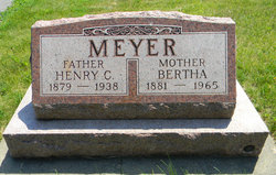
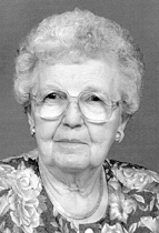
Bertha Sophia Wilhelmine Krambeer Meyer
| Birth | : | 6 Dec 1881 |
| Death | : | 10 Jan 1965 |
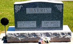
| Burial | : | St. Andrew's Churchyard, Apley, West Lindsey District, England |
| Coordinate | : | 53.2613400, -0.3390200 |
| Description | : | Bertha Krambeer was born Dec. 6, 1881, in Read Township, Clayton county, the daughter of John Krambeer and Ida Harnack. She was baptized Bertha Sophie Wilhelmine by Rev. F. W. Seifert, pastor of the Clayton Center Lutheran church, Dec. 25, 1881. She attended the rural schools at Hardin and West Grove. She was united in marriage with Henry Meyer, March 21, 1901, and the couple engaged in farming west of Postville. Mr. Meyer died in 1938. On Sept. 30, 1946 she married Charles Ulish. They resided in Monona until the death of Mr. Ulish in 1963, after which she made... Read More |
frequently asked questions (FAQ):
-
Where is Bertha Sophia Wilhelmine Krambeer Meyer's memorial?
Bertha Sophia Wilhelmine Krambeer Meyer's memorial is located at: St. Andrew's Churchyard, Apley, West Lindsey District, England.
-
When did Bertha Sophia Wilhelmine Krambeer Meyer death?
Bertha Sophia Wilhelmine Krambeer Meyer death on 10 Jan 1965 in
-
Where are the coordinates of the Bertha Sophia Wilhelmine Krambeer Meyer's memorial?
Latitude: 53.2613400
Longitude: -0.3390200
Family Members:
Spouse
Children
Flowers:


Nearby Cemetories:
1. St. Andrew's Churchyard
Apley, West Lindsey District, England
Coordinate: 53.2613400, -0.3390200
2. St Andrew's Churchyard
Bardney, West Lindsey District, England
Coordinate: 53.2442000, -0.3351800
3. St. Edward's Churchyard
Barlings, West Lindsey District, England
Coordinate: 53.2600000, -0.3890000
4. St. Oswald's Churchyard
Rand, West Lindsey District, England
Coordinate: 53.2970600, -0.3404500
5. St. Giles' Churchyard
Langton by Wragby, East Lindsey District, England
Coordinate: 53.2764400, -0.2777700
6. Barlings Cemetery
Langworth, West Lindsey District, England
Coordinate: 53.2728290, -0.4041870
7. Bardney Abbey
Bardney, West Lindsey District, England
Coordinate: 53.2204000, -0.3336000
8. St. John the Baptist Churchyard
Langworth, West Lindsey District, England
Coordinate: 53.2843900, -0.4086800
9. St. Lawrence Churchyard
Bardney, West Lindsey District, England
Coordinate: 53.2095580, -0.3254380
10. Bardney Cemetery
Bardney, West Lindsey District, England
Coordinate: 53.2078350, -0.3208830
11. All Saints Churchyard
Holton-cum-Beckering, West Lindsey District, England
Coordinate: 53.3167370, -0.3257753
12. All Saints Churchyard
Snelland, West Lindsey District, England
Coordinate: 53.3120800, -0.3812000
13. St. Clement's Churchyard
Fiskerton, West Lindsey District, England
Coordinate: 53.2345500, -0.4315200
14. St. Stephen's Churchyard
Hatton, East Lindsey District, England
Coordinate: 53.2758321, -0.2357834
15. All Saints Churchyard
Gautby, East Lindsey District, England
Coordinate: 53.2359800, -0.2413800
16. St. Peter and St. Paul Churchyard
Reepham, West Lindsey District, England
Coordinate: 53.2518050, -0.4450120
17. Hawthorn Road Cemetery
Reepham, West Lindsey District, England
Coordinate: 53.2489252, -0.4513445
18. Scothern Cemetery
Scothern, West Lindsey District, England
Coordinate: 53.2798200, -0.4515500
19. St. Edward the Confessor Churchyard
Sudbrooke, West Lindsey District, England
Coordinate: 53.2717840, -0.4553930
20. St. Germain Churchyard
Scothern, West Lindsey District, England
Coordinate: 53.2835790, -0.4513370
21. St. Peter & St. Paul Churchyard
Cherry Willingham, West Lindsey District, England
Coordinate: 53.2387000, -0.4553800
22. St. John The Baptist Churchyard
Lissington, West Lindsey District, England
Coordinate: 53.3363600, -0.3359800
23. St. Mary's Churchyard
East Barkwith, East Lindsey District, England
Coordinate: 53.3175900, -0.2514400
24. St. Margaret's Churchyard
Bucknall, East Lindsey District, England
Coordinate: 53.2039920, -0.2513250