
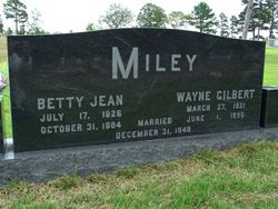
Betty Jean Bourges Miley
| Birth | : | 17 Jul 1926 Long Beach, Los Angeles County, California, USA |
| Death | : | 31 Oct 1984 |
| Burial | : | Agecroft Cemetery and Crematorium, Salford, Metropolitan Borough of Salford, England |
| Coordinate | : | 53.5100250, -2.2940500 |
| Inscription | : | Married Dec. 31, 1949 |
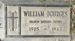
| Description | : | Daughter of William Bourges and Edna May Green Bourges Hitchcock Betty Jean Bourges in the U.S., Social Security Applications and Claims Index, 1936-2007 Name: Betty Jean Bourges [Betty Borges Coleman] [Betty Thompson] [Betty Miley] [Betty Jean Borges] Gender: Female Race: White Birth Date: 17 Jul 1926 Birth Place: Long Beach, California Death Date: Oct 1984 Father: William Borges Mother: Edna M Greene |
frequently asked questions (FAQ):
-
Where is Betty Jean Bourges Miley's memorial?
Betty Jean Bourges Miley's memorial is located at: Agecroft Cemetery and Crematorium, Salford, Metropolitan Borough of Salford, England.
-
When did Betty Jean Bourges Miley death?
Betty Jean Bourges Miley death on 31 Oct 1984 in
-
Where are the coordinates of the Betty Jean Bourges Miley's memorial?
Latitude: 53.5100250
Longitude: -2.2940500
Family Members:
Parent
Spouse
Flowers:


Nearby Cemetories:
1. Agecroft Cemetery and Crematorium
Salford, Metropolitan Borough of Salford, England
Coordinate: 53.5100250, -2.2940500
2. Agecroft Jewish Cemetery
Pendlebury, Metropolitan Borough of Salford, England
Coordinate: 53.5110302, -2.2955830
3. Rainsough Jewish Cemetery
Prestwich, Metropolitan Borough of Bury, England
Coordinate: 53.5185530, -2.2906950
4. St John The Evangelist Churchyard
Pendlebury, Metropolitan Borough of Salford, England
Coordinate: 53.5036200, -2.3088500
5. St Paul's Churchyard
Salford, Metropolitan Borough of Salford, England
Coordinate: 53.5148800, -2.2725500
6. Saint Augustine's Churchyard
Pendlebury, Metropolitan Borough of Salford, England
Coordinate: 53.5107070, -2.3223960
7. St. Thomas' Churchyard
Salford, Metropolitan Borough of Salford, England
Coordinate: 53.4921430, -2.2856130
8. St. Mary the Virgin Churchyard
Prestwich, Metropolitan Borough of Bury, England
Coordinate: 53.5294033, -2.2864891
9. Great Synagogue Cemetery
Prestwich, Metropolitan Borough of Bury, England
Coordinate: 53.5315510, -2.2845730
10. St. Paul's Wesleyan Methodist Churchyard
Swinton, Metropolitan Borough of Salford, England
Coordinate: 53.5133900, -2.3397500
11. St. Peter's Churchyard
Swinton, Metropolitan Borough of Salford, England
Coordinate: 53.5119130, -2.3413860
12. St. Marks' Churchyard
Cheetham Hill, Metropolitan Borough of Manchester, England
Coordinate: 53.5113780, -2.2462660
13. Wesleyan Methodist Cemetery
Crumpsall, Metropolitan Borough of Manchester, England
Coordinate: 53.5142870, -2.2447610
14. Weaste Cemetery
Weaste, Metropolitan Borough of Salford, England
Coordinate: 53.4795227, -2.3017540
15. Swinton Cemetery
Swinton, Metropolitan Borough of Salford, England
Coordinate: 53.5183372, -2.3457739
16. St Anne Churchyard
Clifton, Metropolitan Borough of Salford, England
Coordinate: 53.5277070, -2.3391650
17. Strangeways Prison Cemetery (Defunct)
Manchester, Metropolitan Borough of Manchester, England
Coordinate: 53.4925000, -2.2463890
18. Irwell Street Wesleyan Chapel Cemetery
Salford, Metropolitan Borough of Salford, England
Coordinate: 53.4829750, -2.2587540
19. Manchester Reform Jewish Old Cemetery
Whitefield, Metropolitan Borough of Bury, England
Coordinate: 53.5442728, -2.2918894
20. New Jerusalem Temple Cemetery
Salford, Metropolitan Borough of Salford, England
Coordinate: 53.4827720, -2.2571250
21. St Mary the Virgin Churchyard
Eccles, Metropolitan Borough of Salford, England
Coordinate: 53.4843810, -2.3346810
22. St Luke's Churchyard
Cheetham Hill, Metropolitan Borough of Manchester, England
Coordinate: 53.5041660, -2.2354680
23. Christ Church
Salford, Metropolitan Borough of Salford, England
Coordinate: 53.4864284, -2.2497653
24. St Chad's Churchyard
Cheetham Hill, Metropolitan Borough of Manchester, England
Coordinate: 53.4922100, -2.2400500