
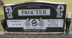
Beverly A Smith Procter
| Birth | : | 16 Jan 1956 California, Moniteau County, Missouri, USA |
| Death | : | 28 Jan 2009 St. Louis City, Missouri, USA |
| Burial | : | Allen Cemetery, Olean, Miller County, USA |
| Coordinate | : | 38.4150009, -92.5008011 |
| Description | : | Beverly A. (Smith) Procter, 53, of Olean, Missouri passed away Wednesday evening January 28, 2009 at Barnes Jewish Hospital in St. Louis, Missouri. She was born in California, Missouri to Leroy Frank and Nelda Marie (Scott) Smith on January 16, 1956. On March 3, 1979 she was married in Russellville, Missouri to Franklin C. Procter who survives of the home. Other survivors include daughter Kelly A. Procter of Guadalajara, Mexico; father Leroy F. Smith of Russellville, Missouri; sisters Barbara M. Crocker of Russellville, Missouri and Brenda M. Eickhorst of Russellville, Missouri; brothers Dale L. Smith of Jefferson... Read More |
frequently asked questions (FAQ):
-
Where is Beverly A Smith Procter's memorial?
Beverly A Smith Procter's memorial is located at: Allen Cemetery, Olean, Miller County, USA.
-
When did Beverly A Smith Procter death?
Beverly A Smith Procter death on 28 Jan 2009 in St. Louis City, Missouri, USA
-
Where are the coordinates of the Beverly A Smith Procter's memorial?
Latitude: 38.4150009
Longitude: -92.5008011
Family Members:
Parent
Siblings

Flowers:


Nearby Cemetories:
1. Allen Cemetery
Olean, Miller County, USA
Coordinate: 38.4150009, -92.5008011
2. Olean Cemetery
Olean, Miller County, USA
Coordinate: 38.4131012, -92.5413971
3. Farris Cemetery
Moniteau County, USA
Coordinate: 38.4369900, -92.5380000
4. Jackson Chapel Methodist Church Cemetery
California, Moniteau County, USA
Coordinate: 38.4447900, -92.5286500
5. Walker Cemetery
Moniteau County, USA
Coordinate: 38.4338989, -92.5522003
6. Etter-Walker Cemetery
Burris Fork, Moniteau County, USA
Coordinate: 38.4333700, -92.5525400
7. Green Ridge Baptist Church Cemetery
Eldon, Miller County, USA
Coordinate: 38.4116200, -92.5645700
8. Gray Cemetery
Moniteau County, USA
Coordinate: 38.4536018, -92.5456009
9. Bruce-Lewis-McGahan Cemetery
Enon, Moniteau County, USA
Coordinate: 38.4667500, -92.5172100
10. Rock Enon Cemetery
Miller County, USA
Coordinate: 38.4668400, -92.5170700
11. Mount Pleasant Cemetery
Eldon, Miller County, USA
Coordinate: 38.3667700, -92.5300800
12. Matheis Cemetery
Russellville, Cole County, USA
Coordinate: 38.4571800, -92.4491600
13. Mount Vernon Cemetery
Eldon, Miller County, USA
Coordinate: 38.3624992, -92.5606003
14. Salem Cemetery
Saline Township, Miller County, USA
Coordinate: 38.3691232, -92.5697260
15. Salem Cemetery
Eldon, Miller County, USA
Coordinate: 38.3697014, -92.5714035
16. Hite Cemetery
Miller County, USA
Coordinate: 38.4039001, -92.5935974
17. Spring Garden Cemetery
Spring Garden, Miller County, USA
Coordinate: 38.3922005, -92.4111023
18. Enon Cemetery
Russellville, Cole County, USA
Coordinate: 38.4888992, -92.4730988
19. Roark Cemetery
Russellville, Cole County, USA
Coordinate: 38.4696999, -92.4255981
20. Karnes-Carney-Henderson Cemetery
Burris Fork, Moniteau County, USA
Coordinate: 38.4992100, -92.5007510
21. Eldon Cemetery
Eldon, Miller County, USA
Coordinate: 38.3642006, -92.5868988
22. Belleville Cemetery
Russellville, Cole County, USA
Coordinate: 38.4970490, -92.4667150
23. Campbell Cemetery
Cole County, USA
Coordinate: 38.4810982, -92.4297028
24. Farmer Cemetery
Hickory Hill, Cole County, USA
Coordinate: 38.4143500, -92.3889790