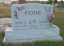
Beverly Myrtle Wrangham Fode
| Birth | : | 2 May 1938 Bismarck, Burleigh County, North Dakota, USA |
| Death | : | 26 Oct 2010 Marion, Grant County, Indiana, USA |
| Burial | : | Saint Pauls Evangelical Lutheran Cemetery, Lake Mills, Jefferson County, USA |
| Coordinate | : | 43.0591800, -88.9218900 |
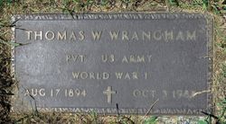
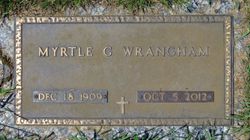
| Description | : | Beverly M. Fode, 72, passed away at 7:19 a.m. Tuesday morning at Marion General Hospital, Marion. She was born in Bismarck, North Dakota, the daughter of Thomas and Myrtle (Snyder) Wrangham. She graduated from Bismarck High School in 1956. She married Ted Fode on September 5, 1958. He preceded her in death on November 7, 2006. Mrs. Fode loved God, her family, and many special friends. She enjoyed bowling, playing cards, crafts, and flower gardening. She was a member of the Upland United Methodist Church. She was also a member of Upland Order of the Eastern Star, Tri-O-Dice Club, and... Read More |
frequently asked questions (FAQ):
-
Where is Beverly Myrtle Wrangham Fode's memorial?
Beverly Myrtle Wrangham Fode's memorial is located at: Saint Pauls Evangelical Lutheran Cemetery, Lake Mills, Jefferson County, USA.
-
When did Beverly Myrtle Wrangham Fode death?
Beverly Myrtle Wrangham Fode death on 26 Oct 2010 in Marion, Grant County, Indiana, USA
-
Where are the coordinates of the Beverly Myrtle Wrangham Fode's memorial?
Latitude: 43.0591800
Longitude: -88.9218900
Family Members:
Parent
Spouse
Siblings
Flowers:
Nearby Cemetories:
1. Saint Pauls Evangelical Lutheran Cemetery
Lake Mills, Jefferson County, USA
Coordinate: 43.0591800, -88.9218900
2. Rock Lake Cemetery
Lake Mills, Jefferson County, USA
Coordinate: 43.0896988, -88.9131012
3. Aztalan Cemetery
Milford, Jefferson County, USA
Coordinate: 43.0839005, -88.8630981
4. Saint Johns Evangelical Lutheran Cemetery
Lake Mills, Jefferson County, USA
Coordinate: 43.1074982, -88.9441986
5. North Oakland Cemetery
Oakland, Jefferson County, USA
Coordinate: 43.0018997, -88.9088974
6. Kroghville Cemetery
Kroghville, Jefferson County, USA
Coordinate: 43.0663800, -89.0069400
7. Gericke Cemetery
Kroghville, Jefferson County, USA
Coordinate: 43.0674930, -89.0115740
8. Neville Cemetery
Waterloo, Jefferson County, USA
Coordinate: 43.1289270, -88.9312040
9. Lake Ripley Cemetery
Cambridge, Jefferson County, USA
Coordinate: 43.0041809, -89.0011673
10. Salem Evangelical United Brethren Cemetery
Milford, Jefferson County, USA
Coordinate: 43.0972710, -88.8208313
11. Oakland Center Cemetery
Oakland, Jefferson County, USA
Coordinate: 42.9767200, -88.9532600
12. Arity Family Cemetery
Fort Atkinson, Jefferson County, USA
Coordinate: 42.9787800, -88.8753600
13. Willerup Methodist Cemetery
Cambridge, Dane County, USA
Coordinate: 43.0021019, -89.0225067
14. Saint Pius X Church Cemetery
Cambridge, Dane County, USA
Coordinate: 42.9997670, -89.0264230
15. Greenwood Cemetery
Jefferson, Jefferson County, USA
Coordinate: 43.0116997, -88.8041992
16. Jefferson County Potters Field Cemetery
Jefferson, Jefferson County, USA
Coordinate: 42.9904870, -88.8247690
17. Ward Cemetery
Oakland, Jefferson County, USA
Coordinate: 42.9616680, -88.8955740
18. South Road Cemetery
Waterloo, Jefferson County, USA
Coordinate: 43.1467018, -88.9914017
19. Saint Wenceslaus Cemetery
Waterloo, Jefferson County, USA
Coordinate: 43.1611000, -88.9218000
20. Saint John the Baptist Catholic Cemetery
Jefferson, Jefferson County, USA
Coordinate: 43.0099983, -88.7985992
21. Saint Marys Cemetery
Johnson Creek, Jefferson County, USA
Coordinate: 43.0685997, -88.7814026
22. Union Cemetery
Jefferson, Jefferson County, USA
Coordinate: 43.0107994, -88.7966995
23. German Methodist Cemetery
Milford, Jefferson County, USA
Coordinate: 43.1221619, -88.8025208
24. Oakland Evergreen Cemetery
Oakland, Jefferson County, USA
Coordinate: 42.9533000, -88.9541300


