
| Birth | : | 1 Jul 1972 Saint Louis, St. Louis City, Missouri, USA |
| Death | : | 27 Jun 2021 Saint Louis, St. Louis City, Missouri, USA |
| Burial | : | Allen Cemetery, Olean, Miller County, USA |
| Coordinate | : | 38.4150009, -92.5008011 |
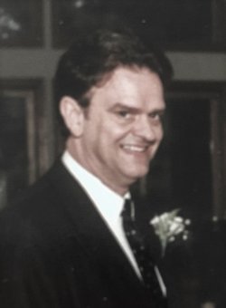
| Description | : | Bo Darwin Hader St. Louis - Bo Darwin Hader of St. Louis, Missouri, was born July 1, 1972, in St. Louis, Missouri to Robert and Sherry Hader and entered into rest, Sunday, June 27, 2021 in St. Louis, Missouri, at the age of forty eight years. He is survived by two daughters, born to Heather Hader: Ebony and Destiny Hader; a half-sibling: Jacob Hader; two aunts: Rosemary (James) Long and Ramona Hader; four cousins: Mark Long , Marcia Long, Matt (Erin) Hader and Diedra Hader. He is preceded in death by his grandparents: Jesse and Esta Hader; his father:... Read More |
frequently asked questions (FAQ):
-
Where is Bo Darwin Hader's memorial?
Bo Darwin Hader's memorial is located at: Allen Cemetery, Olean, Miller County, USA.
-
When did Bo Darwin Hader death?
Bo Darwin Hader death on 27 Jun 2021 in Saint Louis, St. Louis City, Missouri, USA
-
Where are the coordinates of the Bo Darwin Hader's memorial?
Latitude: 38.4150009
Longitude: -92.5008011
Family Members:
Parent
Flowers:


Nearby Cemetories:
1. Allen Cemetery
Olean, Miller County, USA
Coordinate: 38.4150009, -92.5008011
2. Olean Cemetery
Olean, Miller County, USA
Coordinate: 38.4131012, -92.5413971
3. Farris Cemetery
Moniteau County, USA
Coordinate: 38.4369900, -92.5380000
4. Jackson Chapel Methodist Church Cemetery
California, Moniteau County, USA
Coordinate: 38.4447900, -92.5286500
5. Walker Cemetery
Moniteau County, USA
Coordinate: 38.4338989, -92.5522003
6. Etter-Walker Cemetery
Burris Fork, Moniteau County, USA
Coordinate: 38.4333700, -92.5525400
7. Green Ridge Baptist Church Cemetery
Eldon, Miller County, USA
Coordinate: 38.4116200, -92.5645700
8. Gray Cemetery
Moniteau County, USA
Coordinate: 38.4536018, -92.5456009
9. Bruce-Lewis-McGahan Cemetery
Enon, Moniteau County, USA
Coordinate: 38.4667500, -92.5172100
10. Rock Enon Cemetery
Miller County, USA
Coordinate: 38.4668400, -92.5170700
11. Mount Pleasant Cemetery
Eldon, Miller County, USA
Coordinate: 38.3667700, -92.5300800
12. Matheis Cemetery
Russellville, Cole County, USA
Coordinate: 38.4571800, -92.4491600
13. Mount Vernon Cemetery
Eldon, Miller County, USA
Coordinate: 38.3624992, -92.5606003
14. Salem Cemetery
Saline Township, Miller County, USA
Coordinate: 38.3691232, -92.5697260
15. Salem Cemetery
Eldon, Miller County, USA
Coordinate: 38.3697014, -92.5714035
16. Hite Cemetery
Miller County, USA
Coordinate: 38.4039001, -92.5935974
17. Spring Garden Cemetery
Spring Garden, Miller County, USA
Coordinate: 38.3922005, -92.4111023
18. Enon Cemetery
Russellville, Cole County, USA
Coordinate: 38.4888992, -92.4730988
19. Roark Cemetery
Russellville, Cole County, USA
Coordinate: 38.4696999, -92.4255981
20. Karnes-Carney-Henderson Cemetery
Burris Fork, Moniteau County, USA
Coordinate: 38.4992100, -92.5007510
21. Eldon Cemetery
Eldon, Miller County, USA
Coordinate: 38.3642006, -92.5868988
22. Belleville Cemetery
Russellville, Cole County, USA
Coordinate: 38.4970490, -92.4667150
23. Campbell Cemetery
Cole County, USA
Coordinate: 38.4810982, -92.4297028
24. Farmer Cemetery
Hickory Hill, Cole County, USA
Coordinate: 38.4143500, -92.3889790