| Birth | : | 5 Sep 1923 Alcester, Union County, South Dakota, USA |
| Death | : | 25 Apr 2011 Clay County, South Dakota, USA |
| Burial | : | Saint Paul Cemetery, Elk Point, Union County, USA |
| Coordinate | : | 42.7641983, -96.7061005 |
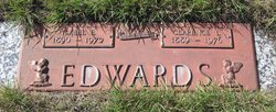
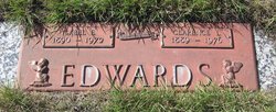
| Description | : | Bonnie Bell (Edwards-Haines) Anderson, 87, passed away Monday, April 25, 2011 at the Morningside Manor in Alcester, SD. Bonnie was born on September 5, 1923 on a farm in rural Vermillion to Clarence and Isabel Edwards. When she was young, Bonnie's mother suffered an illness which led to Bonnie living with Prof. and Mrs. Haines of Vermillion, SD, while the Edwards family returned to Montana. In 1941 Bonnie graduated from University High School in Vermillion. After graduation she remained in Vermillion and worked as a telephone operator. She did not meet her parents, brothers and sisters until she made a trip... Read More |
frequently asked questions (FAQ):
-
Where is Bonnie Bell Edwards Anderson's memorial?
Bonnie Bell Edwards Anderson's memorial is located at: Saint Paul Cemetery, Elk Point, Union County, USA.
-
When did Bonnie Bell Edwards Anderson death?
Bonnie Bell Edwards Anderson death on 25 Apr 2011 in Clay County, South Dakota, USA
-
Where are the coordinates of the Bonnie Bell Edwards Anderson's memorial?
Latitude: 42.7641983
Longitude: -96.7061005
Family Members:
Parent
Spouse
Siblings
Flowers:
Nearby Cemetories:
1. Saint Paul Cemetery
Elk Point, Union County, USA
Coordinate: 42.7641983, -96.7061005
2. Union County Poor Farm Cemetery
Union County, USA
Coordinate: 42.7649210, -96.7077580
3. First Brule Creek Cemetery
Elk Point, Union County, USA
Coordinate: 42.7943993, -96.7069016
4. Richland Cemetery
Richland, Union County, USA
Coordinate: 42.7682991, -96.6624985
5. Gores Bluff Cemetery
Union County, USA
Coordinate: 42.8035069, -96.6260468
6. Ahlsborg Lutheran Cemetery
Union County, USA
Coordinate: 42.8228000, -96.7612000
7. Brule Creek Cemetery
Spink Township, Union County, USA
Coordinate: 42.8346510, -96.7324350
8. Dowlin Cemetery
Burbank, Clay County, USA
Coordinate: 42.7789001, -96.8107986
9. Westfield Township Cemetery
Westfield, Plymouth County, USA
Coordinate: 42.7510986, -96.5914001
10. Elk Point Cemetery
Elk Point, Union County, USA
Coordinate: 42.6794586, -96.6794586
11. Saint Joseph Cemetery
Elk Point, Union County, USA
Coordinate: 42.6794014, -96.6797028
12. Mills Family Cemetery
Westfield, Plymouth County, USA
Coordinate: 42.7188460, -96.6019280
13. Pleasant Hill Cemetery Old
Spink, Union County, USA
Coordinate: 42.8588462, -96.7215592
14. Saint Mary Cemetery
Union County, USA
Coordinate: 42.8520584, -96.7877502
15. Saint Agnes Cemetery
Vermillion, Clay County, USA
Coordinate: 42.7872009, -96.8499985
16. Pleasant Hill Cemetery
Spink, Union County, USA
Coordinate: 42.8741000, -96.6876000
17. Ionia Cemetery
Newcastle, Dixon County, USA
Coordinate: 42.6893997, -96.8300018
18. Gibb's Cemetery
Newcastle, Dixon County, USA
Coordinate: 42.6985100, -96.8518400
19. Saint Patricks Cemetery
Akron, Plymouth County, USA
Coordinate: 42.8232300, -96.5374800
20. Riverside Cemetery
Akron, Plymouth County, USA
Coordinate: 42.8367004, -96.5453033
21. Dewitt Cemetery
Ponca, Dixon County, USA
Coordinate: 42.6248000, -96.7437500
22. Bluff View Cemetery
Vermillion, Clay County, USA
Coordinate: 42.7714000, -96.9056000
23. Saint Agnes Calvary Cemetery
Vermillion, Clay County, USA
Coordinate: 42.7715900, -96.9072100
24. Saint Peter Greenfield Cemetery
Vermillion, Clay County, USA
Coordinate: 42.8608017, -96.8644028


