
| Birth | : | 28 Aug 1923 Clifton, Washington County, Kansas, USA |
| Death | : | 16 Nov 1994 Wichita, Sedgwick County, Kansas, USA |
| Burial | : | Mount Calvary Cemetery, Clyde, Cloud County, USA |
| Coordinate | : | 39.5917015, -97.4143982 |
| Plot | : | Site J/11 |
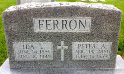
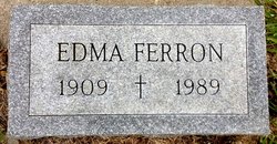
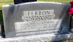
| Inscription | : | Married Aug 19, 1947 Parents of Steven, Juanita and Daniel |
| Description | : | Salina Journal – Nov. 17, 1994 Buford Ferron AMES — Buford Ferron, 71, Ames, died Wednesday, Nov. 16, 1994, at St. Francis Regional Medical Center, Wichita. Mr. Ferron was born Aug. 28, 1923, at Clifton. He worked at the Curtiss/Wright Aircraft factory, Buffalo, N.Y., during World War II. He was a farmer, a member of the Moose Lodge and St. John the Baptist Catholic Church, both of Clyde, and a former member of the Knights of Columbus. Survivors include his wife, LaVita of Ames; two sons, Steven of Tescott and Daniel of Concordia; a daughter, Juanita Bauer of Concordia; a brother, Raymond of... Read More |
frequently asked questions (FAQ):
-
Where is Buford L Ferron's memorial?
Buford L Ferron's memorial is located at: Mount Calvary Cemetery, Clyde, Cloud County, USA.
-
When did Buford L Ferron death?
Buford L Ferron death on 16 Nov 1994 in Wichita, Sedgwick County, Kansas, USA
-
Where are the coordinates of the Buford L Ferron's memorial?
Latitude: 39.5917015
Longitude: -97.4143982
Family Members:
Parent

Spouse

Siblings
Children
Flowers:


Nearby Cemetories:
1. Mount Calvary Cemetery
Clyde, Cloud County, USA
Coordinate: 39.5917015, -97.4143982
2. Mount Hope Cemetery
Clyde, Cloud County, USA
Coordinate: 39.5969009, -97.4116974
3. Cedar Grove Cemetery
Clyde, Cloud County, USA
Coordinate: 39.5494003, -97.4056015
4. Pleasant View Cemetery
Ames, Cloud County, USA
Coordinate: 39.5346985, -97.4431000
5. Walnut Grove Cemetery
Cloud County, USA
Coordinate: 39.5699997, -97.4993973
6. Saint Joseph Cemetery
Saint Joseph, Cloud County, USA
Coordinate: 39.5074941, -97.4022328
7. Agenda Cemetery
Agenda, Republic County, USA
Coordinate: 39.6761017, -97.4336014
8. Green Mound Cemetery
Rice, Cloud County, USA
Coordinate: 39.5248450, -97.5081630
9. Hollis Cemetery
Cloud County, USA
Coordinate: 39.6383018, -97.5361023
10. Beck Family Cemetery
Agenda, Republic County, USA
Coordinate: 39.6818000, -97.4863000
11. Rice Cemetery
Rice, Cloud County, USA
Coordinate: 39.5614014, -97.5552979
12. Nelson Cemetery
Rice, Cloud County, USA
Coordinate: 39.5257988, -97.5410995
13. Riverdale Cemetery
Clay County, USA
Coordinate: 39.5106010, -97.2930984
14. Saint Peters Cemetery
Aurora, Cloud County, USA
Coordinate: 39.4763985, -97.5180969
15. Princeville Cemetery
Aurora, Cloud County, USA
Coordinate: 39.4672012, -97.5010986
16. Iwacura Cemetery
Morganville, Clay County, USA
Coordinate: 39.4550000, -97.3510000
17. Union Cemetery
Wayne, Republic County, USA
Coordinate: 39.6977997, -97.5457993
18. Willoughby Cemetery
Agenda, Republic County, USA
Coordinate: 39.7402992, -97.4244003
19. French Presbyterian Church Cemetery
Cloud County, USA
Coordinate: 39.4395200, -97.4148290
20. Gotland Cemetery
Sibley Township, Cloud County, USA
Coordinate: 39.6091995, -97.6125031
21. Sherman Cemetery
Morganville, Clay County, USA
Coordinate: 39.5316300, -97.2243700
22. Zion Cemetery
Agenda, Republic County, USA
Coordinate: 39.6749992, -97.5939026
23. Rose Hill Cemetery
Wayne, Republic County, USA
Coordinate: 39.7111015, -97.5661011
24. Minersville Cemetery
Talmo, Republic County, USA
Coordinate: 39.6568330, -97.6229250