
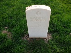
Burton Campbell “Stretch” Thomson
| Birth | : | 27 Jun 1914 Algona, Kossuth County, Iowa, USA |
| Death | : | 15 May 1942 Corregidor Island, Cavite Province, CALABARZON, Philippines |
| Burial | : | Greenwood Cemetery, Birmingham, Oakland County, USA |
| Coordinate | : | 42.5539017, -83.2238998 |
| Plot | : | SECTION D SITE 288 |
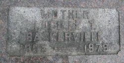
| Inscription | : | CAPT, VETERINARY CORPS WORLD WAR II |
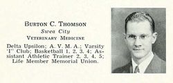
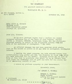
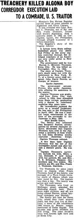
| Description | : | Captain Burton C. "Stretch" Thomson '37. of Swea City, Iowa, played basketball two years for Iowa State before earning his degree in veterinary medicine. In April 1941, twenty-six-year-old, 1st Lieutenant Burton C. Thomson. U. S. Army Veterinary Corps, sailed to his new duty station in the Philippine Islands. He left behind his wife, Olive, and 7-month old son, Kenneth, in Iowa. He was scheduled to be gone for two years. Arriving in Manila in May 1941 he was assigned to the 4th Veterinary Hospital at Fort Stotsenburg in Pampanga Province, Luzon. He was the veterinarian for the 26th Cavalry... Read More |
frequently asked questions (FAQ):
-
Where is Burton Campbell “Stretch” Thomson's memorial?
Burton Campbell “Stretch” Thomson's memorial is located at: Greenwood Cemetery, Birmingham, Oakland County, USA.
-
When did Burton Campbell “Stretch” Thomson death?
Burton Campbell “Stretch” Thomson death on 15 May 1942 in Corregidor Island, Cavite Province, CALABARZON, Philippines
-
Where are the coordinates of the Burton Campbell “Stretch” Thomson's memorial?
Latitude: 42.5539017
Longitude: -83.2238998
Family Members:
Parent
Spouse
Siblings

Flowers:


Nearby Cemetories:
1. Greenwood Cemetery
Birmingham, Oakland County, USA
Coordinate: 42.5539017, -83.2238998
2. Saint James Episcopal Church Columbarium
Birmingham, Oakland County, USA
Coordinate: 42.5465088, -83.2179642
3. First United Methodist Church Memorial Garden
Birmingham, Oakland County, USA
Coordinate: 42.5454370, -83.2330870
4. First Presbyterian Church Columbarium
Birmingham, Oakland County, USA
Coordinate: 42.5463380, -83.2351040
5. Lutheran Church of the Redeemer Columbarium
Birmingham, Oakland County, USA
Coordinate: 42.5463540, -83.2373950
6. Christ Church Cranbrook Columbarium
Bloomfield Hills, Oakland County, USA
Coordinate: 42.5672188, -83.2440186
7. Perrin Cemetery
Troy, Oakland County, USA
Coordinate: 42.5398254, -83.1857605
8. Clover Hill Park Cemetery
Birmingham, Oakland County, USA
Coordinate: 42.5349998, -83.1885986
9. Acacia Park Cemetery
Beverly Hills, Oakland County, USA
Coordinate: 42.5217018, -83.2197037
10. Bloomfield Hills Cemetery (Defunct)
Bloomfield Hills, Oakland County, USA
Coordinate: 42.5811111, -83.2563889
11. Northbrook Presbyterian Church Columbarium
Beverly Hills, Oakland County, USA
Coordinate: 42.5297550, -83.2657280
12. Gilbert Lake Cemetery (Defunct)
Bloomfield, Oakland County, USA
Coordinate: 42.5568800, -83.2799500
13. Saint Hugo of the Hills Columbarium
Bloomfield Hills, Oakland County, USA
Coordinate: 42.5927391, -83.2477036
14. Beach Cemetery
Troy, Oakland County, USA
Coordinate: 42.5936012, -83.1980972
15. Beekman Cemetery
Southfield, Oakland County, USA
Coordinate: 42.5098076, -83.2176285
16. Crooks Road Cemetery
Troy, Oakland County, USA
Coordinate: 42.5727997, -83.1680984
17. Beautiful Savior Lutheran Church Columbarium
Bloomfield Hills, Oakland County, USA
Coordinate: 42.5984290, -83.2092050
18. Payne-Waugh Cemetery
Bloomfield Township, Oakland County, USA
Coordinate: 42.6044640, -83.2385790
19. Saint David Episcopal Church Columbarium
Southfield, Oakland County, USA
Coordinate: 42.5030990, -83.2096400
20. White Chapel Memorial Park Cemetery
Troy, Oakland County, USA
Coordinate: 42.5856018, -83.1635971
21. Roseland Park Cemetery
Berkley, Oakland County, USA
Coordinate: 42.5060997, -83.1797028
22. Kirk in the Hills Columbarium
Bloomfield Hills, Oakland County, USA
Coordinate: 42.5810394, -83.2942886
23. Saint Andrews Memorial Garden
Clawson, Oakland County, USA
Coordinate: 42.5359612, -83.1460571
24. Franklin Cemetery
Franklin, Oakland County, USA
Coordinate: 42.5224991, -83.3059921