
Capt Edmund Benjamin Walters
| Birth | : | 19 Feb 1846 |
| Death | : | 30 Apr 1920 Nova Scotia, Canada |
| Burial | : | Pinecrest Memorial Gardens, Clayton, Johnston County, USA |
| Coordinate | : | 35.6644096, -78.4939880 |
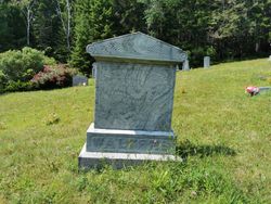
| Inscription | : | WALTERS Louisa 16 Mar 1931 85 yrs 11 mos wife WALTERS Edmen Benjamine 19 Feb 1846 30 Apr 1920 |
| Description | : | LaHave Man Was Drowned Captain Edward Walters, Aged 74 Years, Was Knocked into Sea by Boom of Sail Boat 1920 Lunenburg, April 30- A drowning accident took place today opposite Leary's Shipyards, in the LaHave River, in which Captain Edward Walters lost his life. He and his son, Charles, were at Bridgewater and were returning in their sail boat when at the place mentioned the mailsail jibed, the boom striking Captain Walters and knocked him overboard. It is supposed that he was stunned by the blow from the boom, and he sank immediately. The accident was seen from the shore... Read More |
frequently asked questions (FAQ):
-
Where is Capt Edmund Benjamin Walters's memorial?
Capt Edmund Benjamin Walters's memorial is located at: Pinecrest Memorial Gardens, Clayton, Johnston County, USA.
-
When did Capt Edmund Benjamin Walters death?
Capt Edmund Benjamin Walters death on 30 Apr 1920 in Nova Scotia, Canada
-
Where are the coordinates of the Capt Edmund Benjamin Walters's memorial?
Latitude: 35.6644096
Longitude: -78.4939880
Family Members:
Parent

Spouse

Siblings
Flowers:


Nearby Cemetories:
1. Pinecrest Memorial Gardens
Clayton, Johnston County, USA
Coordinate: 35.6644096, -78.4939880
2. Wiley D. Jones Cemetery
Clayton, Johnston County, USA
Coordinate: 35.6476800, -78.5027010
3. McCullers Cemetery
Clayton, Johnston County, USA
Coordinate: 35.6617012, -78.4677963
4. Clayton City Cemetery
Clayton, Johnston County, USA
Coordinate: 35.6577170, -78.4624260
5. Amelia Christian Church Cemetery
Clayton, Johnston County, USA
Coordinate: 35.6365810, -78.4957920
6. Horne Cemetery
Clayton, Johnston County, USA
Coordinate: 35.6581001, -78.4599991
7. Bell-McCullers Cemetery
Clayton, Johnston County, USA
Coordinate: 35.6811000, -78.4639690
8. Mount Moriah Baptist Church Cemetery
Raleigh, Wake County, USA
Coordinate: 35.6847310, -78.5270990
9. Maplewood Cemetery
Clayton, Johnston County, USA
Coordinate: 35.6441116, -78.4592972
10. Good Samaritan Baptist Church Cemetery
Clayton, Johnston County, USA
Coordinate: 35.6394501, -78.5274963
11. Bunker Hill Cemetery
Clayton, Johnston County, USA
Coordinate: 35.6619400, -78.4470900
12. Mount Herman Christian Church Cemetery
Garner, Wake County, USA
Coordinate: 35.6621399, -78.5468369
13. Burrell Boon Cemetery
Clayton, Johnston County, USA
Coordinate: 35.6164060, -78.4761950
14. Springfield Baptist Church Community Cemetery
Garner, Wake County, USA
Coordinate: 35.6978730, -78.5427090
15. Good Samaritan Baptist Church Cemetery
Garner, Wake County, USA
Coordinate: 35.6576510, -78.5595890
16. Sanders and Williamson Family Cemetery
Clayton, Johnston County, USA
Coordinate: 35.6148580, -78.4650750
17. Poole Cemetery
Clayton, Johnston County, USA
Coordinate: 35.6091995, -78.4760971
18. Forest Hills Cemetery
Clayton, Johnston County, USA
Coordinate: 35.6218240, -78.4453820
19. Auburn Christian Church Cemetery
Garner, Wake County, USA
Coordinate: 35.6963400, -78.5574810
20. Gay Cemetery
Johnston County, USA
Coordinate: 35.6758003, -78.4197006
21. Johns Cemetery
Wake County, USA
Coordinate: 35.7085600, -78.5578440
22. Baptist Center Church Cemetery
Clayton, Johnston County, USA
Coordinate: 35.5973550, -78.4745640
23. H.J. Crocker Cemetery
Clayton, Johnston County, USA
Coordinate: 35.6136450, -78.4350550
24. Piney Grove Cemetery
Clayton, Johnston County, USA
Coordinate: 35.5884760, -78.4860830