
| Birth | : | 9 Jan 1814 |
| Death | : | 25 Apr 1838 Cincinnati, Hamilton County, Ohio, USA |
| Burial | : | Perintown United Methodist Church Cemetery, Perintown, Clermont County, USA |
| Coordinate | : | 39.1374512, -84.2339783 |
| Inscription | : | Perin, Isaac ( Capt), d.25 Apr 1838, ae 24 yr 8 mo 16 da who met an early death by the fatal explosion of the steam boat Moselle |
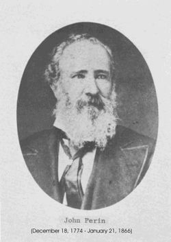
| Description | : | Son of John Perin (1774-1866) and Rachel (Rice) Perin (b.1782). CINCINNATI TIMES STAR, 100th Anniversary Edition:April 25, 1838, the "Moselle", carrying 300 passengers from Cincinnati to St. Louis, was destroyed by an explosion of her boilers. The scene was just above the present L&N Bridge. Capt. Perin, 28 years old, commanded. His torn body was blown ashore. Estimated that between 80 to 230 passengers and crewmen died. |
frequently asked questions (FAQ):
-
Where is Capt Isaac Perin's memorial?
Capt Isaac Perin's memorial is located at: Perintown United Methodist Church Cemetery, Perintown, Clermont County, USA.
-
When did Capt Isaac Perin death?
Capt Isaac Perin death on 25 Apr 1838 in Cincinnati, Hamilton County, Ohio, USA
-
Where are the coordinates of the Capt Isaac Perin's memorial?
Latitude: 39.1374512
Longitude: -84.2339783
Family Members:
Parent
Siblings

Flowers:


Nearby Cemetories:
1. McClure Family Cemetery
Stonelick, Clermont County, USA
Coordinate: 39.1248330, -84.2224500
2. Round Bottom Road Cemetery
Perintown, Clermont County, USA
Coordinate: 39.1400170, -84.2568330
3. Tealtown Cemetery
Perintown, Clermont County, USA
Coordinate: 39.1190500, -84.2419830
4. William Jones Cemetery
Summerside, Clermont County, USA
Coordinate: 39.1304900, -84.2657990
5. Eli Davis Family Cemetery
Summerside, Clermont County, USA
Coordinate: 39.1377580, -84.2838960
6. Mount Zion Cemetery
Craver, Clermont County, USA
Coordinate: 39.1613464, -84.1940231
7. Saint Philomena Church Cemetery
Stonelick Township, Clermont County, USA
Coordinate: 39.1277618, -84.1848450
8. Greenlawn Cemetery
Milford, Clermont County, USA
Coordinate: 39.1706009, -84.2758026
9. Hill Family Cemetery
Stonelick, Clermont County, USA
Coordinate: 39.1622490, -84.1826090
10. Olive Branch Cemetery
Olive Branch, Clermont County, USA
Coordinate: 39.0850000, -84.2261800
11. Saint Andrews Cemetery
Milford, Clermont County, USA
Coordinate: 39.1632996, -84.2941971
12. Jesuit Cemetery
Milford, Clermont County, USA
Coordinate: 39.1655400, -84.2932700
13. Dial Family Cemetery
Olive Branch, Clermont County, USA
Coordinate: 39.0823670, -84.2118670
14. Mulberry Cemetery
Milford, Clermont County, USA
Coordinate: 39.1947784, -84.2469864
15. Milford First United Methodist Church Columbarium
Milford, Clermont County, USA
Coordinate: 39.1768880, -84.2910680
16. Saint Thomas Episcopal Church Columbarium
Terrace Park, Hamilton County, USA
Coordinate: 39.1666300, -84.3029760
17. Milford Cemetery
Milford, Clermont County, USA
Coordinate: 39.1795550, -84.2908500
18. Covalt Cemetery
Terrace Park, Hamilton County, USA
Coordinate: 39.1671400, -84.3028080
19. Rapp Cemetery
Belfast, Clermont County, USA
Coordinate: 39.1434900, -84.1529200
20. Stonelick IOOF Cemetery
Stonelick, Clermont County, USA
Coordinate: 39.1205200, -84.1549100
21. Olive Cemetery
Stonelick Township, Clermont County, USA
Coordinate: 39.1563988, -84.1552963
22. Graceland Memorial Gardens
Milford, Clermont County, USA
Coordinate: 39.1963997, -84.1999969
23. Brown Family Cemetery
Top-of-the-Ridge, Clermont County, USA
Coordinate: 39.1968980, -84.2695320
24. Marriott Cemetery (Defunct)
Ancor, Hamilton County, USA
Coordinate: 39.1442610, -84.3187690