
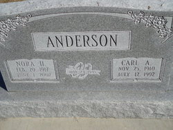
Carl A Anderson
| Birth | : | 25 Nov 1910 Loup City, Sherman County, Nebraska, USA |
| Death | : | 12 Jun 1992 Broken Bow, Custer County, Nebraska, USA |
| Burial | : | Evergreen Cemetery, Loup City, Sherman County, USA |
| Coordinate | : | 41.2997017, -98.9852982 |
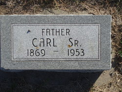
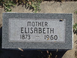
| Description | : | CARL ANDERSON - Sherman County farmer, 81 Carl A. Anderson, 81, of Berwyn died Sunday, July 12, 1992 in Broken Bow. Services will be 10 a.m. Wednesday at Govier Brothers Chapel in Broken Bow with the Rev. Matt Wentz officiating. Burial will be at Evergreen Cemetery at Loup City with Govier Brothers Mortuary of Broken Bow in charge. He was born Nov. 25, 1910, at Loup City, to Carl and Elizabeth (Svensen) Anderson Sr. He grew up on a farm in the Loup City area. As a young man he enjoyed playing baseball with area town teams. |
frequently asked questions (FAQ):
-
Where is Carl A Anderson's memorial?
Carl A Anderson's memorial is located at: Evergreen Cemetery, Loup City, Sherman County, USA.
-
When did Carl A Anderson death?
Carl A Anderson death on 12 Jun 1992 in Broken Bow, Custer County, Nebraska, USA
-
Where are the coordinates of the Carl A Anderson's memorial?
Latitude: 41.2997017
Longitude: -98.9852982
Family Members:
Parent
Spouse

Siblings

Children
Flowers:


Nearby Cemetories:
1. Evergreen Cemetery
Loup City, Sherman County, USA
Coordinate: 41.2997017, -98.9852982
2. Saint Josaphats Cemetery
Loup City, Sherman County, USA
Coordinate: 41.3022003, -98.9847031
3. Sunny Slope Cemetery
Loup City, Sherman County, USA
Coordinate: 41.2906000, -99.0267000
4. Cleoria Cemetery
Loup City, Sherman County, USA
Coordinate: 41.2779000, -99.0893500
5. Balsora Cemetery
Sherman County, USA
Coordinate: 41.3782997, -99.0975037
6. Austin Cemetery
Rockville, Sherman County, USA
Coordinate: 41.1880989, -98.8981018
7. Verdurette Cemetery
Sherman County, USA
Coordinate: 41.1697006, -98.9757996
8. Davis Creek Cemetery
Valley County, USA
Coordinate: 41.4219017, -98.9052963
9. Saint Francis Cemetery
Ashton, Sherman County, USA
Coordinate: 41.2438000, -98.7994000
10. Lone Elm Cemetery
Loup City, Sherman County, USA
Coordinate: 41.2921982, -99.1864014
11. Immanuel Lutheran Cemetery
Ashton, Sherman County, USA
Coordinate: 41.2140000, -98.8142000
12. Gray Cemetery
Sherman County, USA
Coordinate: 41.2099991, -99.1567001
13. Arcadia Cemetery
Arcadia, Valley County, USA
Coordinate: 41.4237000, -99.1167000
14. Pleasant Hill Friends Cemetery
Valley County, USA
Coordinate: 41.4230800, -98.8377700
15. Dunkard Cemetery
Arcadia, Valley County, USA
Coordinate: 41.4522000, -99.0769000
16. Union Cemetery
Ashton, Sherman County, USA
Coordinate: 41.2214012, -98.7855988
17. Litchfield Cemetery
Litchfield, Sherman County, USA
Coordinate: 41.1543999, -99.1283035
18. Mount Carmel Cemetery
Howard County, USA
Coordinate: 41.2797012, -98.7328033
19. Salem Evangelical Church Cemetery
Ord, Valley County, USA
Coordinate: 41.4902992, -98.9244003
20. Lewis Burial Plat
Litchfield, Sherman County, USA
Coordinate: 41.1383000, -99.1484000
21. Trinity Lutheran Church Cemetery
Hazard, Sherman County, USA
Coordinate: 41.0913000, -99.0052000
22. Lee Park Cemetery
Custer County, USA
Coordinate: 41.4025002, -99.2307968
23. Lee Park Catholic Cemetery
Westerville, Custer County, USA
Coordinate: 41.4091988, -99.2311020
24. Saint Marys Cemetery
Rockville, Sherman County, USA
Coordinate: 41.1202000, -98.8255000