

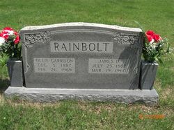
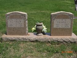
Carl Douglas Rainbolt
| Birth | : | 8 Aug 1907 |
| Death | : | 11 Jan 1974 |
| Burial | : | Bolton Street Cemetery, Wellington, Wellington City, New Zealand |
| Coordinate | : | -41.2786810, 174.7727660 |
| Description | : | Last Known Residence: Saint Joe, Searcy County, Arkansas Social Security Death Index: 2 December 2009 ******************* 1920 Census @ : District 0114, Prairie, Searcy County, Arkansas Page# 7 Individual# 35 ************************** Carl is listed in the SSDI as Carl Rainbolt, I went to ancestry.com, and his DOB and DOD match up with the son of James D Rainbolt and Ollie {Garrison} Rainbolt... I have attached his parents to him ************************** |
frequently asked questions (FAQ):
-
Where is Carl Douglas Rainbolt's memorial?
Carl Douglas Rainbolt's memorial is located at: Bolton Street Cemetery, Wellington, Wellington City, New Zealand.
-
When did Carl Douglas Rainbolt death?
Carl Douglas Rainbolt death on 11 Jan 1974 in
-
Where are the coordinates of the Carl Douglas Rainbolt's memorial?
Latitude: -41.2786810
Longitude: 174.7727660
Family Members:
Parent

Spouse
Siblings
Children


Nearby Cemetories:
1. Bolton Street Cemetery
Wellington, Wellington City, New Zealand
Coordinate: -41.2786810, 174.7727660
2. Mount Street Cemetery
Wellington, Wellington City, New Zealand
Coordinate: -41.2888040, 174.7713370
3. Karori Cemetery and Crematorium
Wellington, Wellington City, New Zealand
Coordinate: -41.2804030, 174.7512000
4. New Zealand National War Memorial
Wellington, Wellington City, New Zealand
Coordinate: -41.2990000, 174.7771620
5. Saint Mary's Anglican Churchyard
Wellington, Wellington City, New Zealand
Coordinate: -41.2826680, 174.7438880
6. Massey Memorial
Wellington, Wellington City, New Zealand
Coordinate: -41.2850700, 174.8259900
7. Truby King House and Gardens
Melrose, Wellington City, New Zealand
Coordinate: -41.3201760, 174.7889800
8. Our Lady’s Home of Compassion
Island Bay, Wellington City, New Zealand
Coordinate: -41.3287970, 174.7704430
9. St. Matthias Anglican Church Cemetery
Makara, Wellington City, New Zealand
Coordinate: -41.2694440, 174.7047270
10. Tapu Te Ranga Marae
Wellington City, New Zealand
Coordinate: -41.3316963, 174.7698099
11. Makara Cemetery
Wellington, Wellington City, New Zealand
Coordinate: -41.2769430, 174.7016600
12. Johnsonville Methodist Cemetery
Wellington, Wellington City, New Zealand
Coordinate: -41.2229000, 174.8083500
13. St. John's Anglican Churchyard Cemetery
Johnsonville, Wellington City, New Zealand
Coordinate: -41.2201300, 174.8076800
14. Somes Island
Wellington, Wellington City, New Zealand
Coordinate: -41.2548630, 174.8650830
15. Holy Trinity Cemetery
Ohariu, Wellington City, New Zealand
Coordinate: -41.2000860, 174.7793400
16. Te Puni Urupā
Petone, Lower Hutt City, New Zealand
Coordinate: -41.2254898, 174.8686975
17. Korokoro Catholic Cemetery
Lower Hutt, Lower Hutt City, New Zealand
Coordinate: -41.2210110, 174.8702590
18. Pencarrow Head
Eastbourne, Lower Hutt City, New Zealand
Coordinate: -41.3574100, 174.8505900
19. Owhiti Urupā
Seaview, Lower Hutt City, New Zealand
Coordinate: -41.2358800, 174.9044500
20. Bridge Street Cemetery
Lower Hutt, Lower Hutt City, New Zealand
Coordinate: -41.2117740, 174.8969660
21. St. James Churchyard
Lower Hutt, Lower Hutt City, New Zealand
Coordinate: -41.2128840, 174.9003910
22. Grasslees Reserve
Tawa, Wellington City, New Zealand
Coordinate: -41.1647415, 174.8284302
23. Tawa Flat Cemetery
Tawa, Wellington City, New Zealand
Coordinate: -41.1580600, 174.8281800
24. Homedale Methodist Cemetery
Wainuiomata, Lower Hutt City, New Zealand
Coordinate: -41.2780500, 174.9527000