
| Birth | : | 24 Jun 1876 Rankesed, Arvika kommun, Värmlands län, Sweden |
| Death | : | 13 Nov 1958 Omaha, Douglas County, Nebraska, USA |
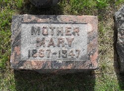
| Burial | : | Evergreen Memorial Park Cemetery, Omaha, Douglas County, USA |
| Coordinate | : | 41.2393990, -96.0355988 |
| Plot | : | Section F, Lot 952, Grave 5 |
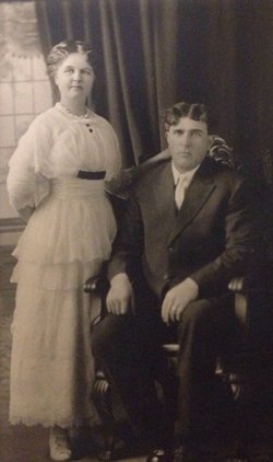
| Description | : | Carl was a policeman in Omaha. He married a widow, Beatrice. Beatrice's son, Eldon Lee, married Dora, daughter of Carl's sister Mary and her husband, Gustaf "Vic" Nelson. Carl and Beatrice did not have any children. Carl's youngest and last living niece (2013, 92 years) says it is important to remember that Beatrice is prounounced "Be (long e) a (short a) tri (short i) ce (ss)". Carl's siblings are John (Mary Youngquest)), Mary (Gustaf "Vic" Nelson), Christina (Charles J. Anderson/Bill Payne), Ellen (Chester Baum/Henry Johnson), Gustaf (Florence Estella Nelson Bister Gustafson) and Esther Kathryn (Peter E.... Read More |
frequently asked questions (FAQ):
-
Where is Carl Edwin Bister's memorial?
Carl Edwin Bister's memorial is located at: Evergreen Memorial Park Cemetery, Omaha, Douglas County, USA.
-
When did Carl Edwin Bister death?
Carl Edwin Bister death on 13 Nov 1958 in Omaha, Douglas County, Nebraska, USA
-
Where are the coordinates of the Carl Edwin Bister's memorial?
Latitude: 41.2393990
Longitude: -96.0355988
Family Members:
Parent

Spouse
Siblings
Flowers:


Nearby Cemetories:
1. Evergreen Memorial Park Cemetery
Omaha, Douglas County, USA
Coordinate: 41.2393990, -96.0355988
2. Resurrection Cemetery
Omaha, Douglas County, USA
Coordinate: 41.2344208, -96.0365448
3. Calvary Cemetery
Omaha, Douglas County, USA
Coordinate: 41.2364006, -96.0294037
4. Saint Andrews Episcopal Church Columbarium
Omaha, Douglas County, USA
Coordinate: 41.2492500, -96.0427500
5. Countryside Community Church Columbarium
Omaha, Douglas County, USA
Coordinate: 41.2483660, -96.0500270
6. Ak-Sar-Ben Racetrack Grounds
Omaha, Douglas County, USA
Coordinate: 41.2414703, -96.0159607
7. Beth El Cemetery
Ralston, Douglas County, USA
Coordinate: 41.2117004, -96.0428009
8. Westlawn-Hillcrest Memorial Park
Omaha, Douglas County, USA
Coordinate: 41.2346992, -95.9966965
9. Bohemian Cemetery
Omaha, Douglas County, USA
Coordinate: 41.2388992, -95.9955978
10. Holy Sepulchre Cemetery
Omaha, Douglas County, USA
Coordinate: 41.2543983, -95.9875031
11. All Saints Episcopal Church Columbarium
Omaha, Douglas County, USA
Coordinate: 41.2785000, -96.0579000
12. Douglas County Poor Farm Cemetery
Omaha, Douglas County, USA
Coordinate: 41.2437240, -95.9723480
13. Graceland Park Cemetery
Omaha, Douglas County, USA
Coordinate: 41.2113991, -95.9785995
14. Saint Mary Magdalene Cemetery
Omaha, Douglas County, USA
Coordinate: 41.2039420, -95.9850610
15. Nash Chapel Crypt
Omaha, Douglas County, USA
Coordinate: 41.2665090, -95.9721790
16. First Central Congregational Columbarium
Omaha, Douglas County, USA
Coordinate: 41.2563456, -95.9658365
17. Servants of Mary Cemetery
Omaha, Douglas County, USA
Coordinate: 41.3017170, -96.0258260
18. Papillion Cemetery
Papillion, Sarpy County, USA
Coordinate: 41.1758003, -96.0410995
19. Saint Mary's Cemetery
Omaha, Douglas County, USA
Coordinate: 41.2042007, -95.9646988
20. Mount Hope Cemetery
Omaha, Douglas County, USA
Coordinate: 41.3041992, -96.0310974
21. Portal Cemetery
Sarpy County, USA
Coordinate: 41.1838989, -96.0802994
22. Pleasant Hill Cemetery
Omaha, Douglas County, USA
Coordinate: 41.2558975, -96.1194687
23. Prospect Hill Cemetery
Omaha, Douglas County, USA
Coordinate: 41.2780991, -95.9593964
24. Mount Sinai Cemetery
Omaha, Douglas County, USA
Coordinate: 41.3116989, -96.0314026