
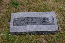
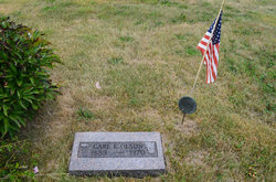
Carl Emil Olson
| Birth | : | 24 Nov 1889 Marshalltown, Marshall County, Iowa, USA |
| Death | : | 27 Jan 1970 Des Moines, Polk County, Iowa, USA |
| Burial | : | Hardin Township Cemetery, Hardin Township, Webster County, USA |
| Coordinate | : | 42.2411003, -93.9708023 |
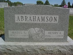
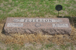
| Description | : | Boone News Republican January 28, 1970 Carl Emil Olson (Stratford) Stratford (Special) - Carl Emil Olson, 80, of Stratford, died Tuesday, Jan. 27, at the Veterans Hospital in Des Moines, where he was admitted Dec. 15. Survivors include 2 sisters, Mrs. Lucille Peterson of Stratford, and Mrs. Mabel Abrahamson of Dayton, Iowa; a brother, Oscar Olson of Colorado Springs, Colo.; and several nieces and nephews. Mr. Olson was preceded in death by his parents; his wife; 2 brothers; and 3 sisters. Funeral services will be held Saturday, Jan. 31, at 2 p.m. at the Stratford Lutheran Church with the pastor, A.M. Youngquist in charge. Military graveside services... Read More |
frequently asked questions (FAQ):
-
Where is Carl Emil Olson's memorial?
Carl Emil Olson's memorial is located at: Hardin Township Cemetery, Hardin Township, Webster County, USA.
-
When did Carl Emil Olson death?
Carl Emil Olson death on 27 Jan 1970 in Des Moines, Polk County, Iowa, USA
-
Where are the coordinates of the Carl Emil Olson's memorial?
Latitude: 42.2411003
Longitude: -93.9708023
Family Members:
Parent
Spouse

Siblings
Flowers:


Nearby Cemetories:
1. Hardin Township Cemetery
Hardin Township, Webster County, USA
Coordinate: 42.2411003, -93.9708023
2. Linn Cemetery
Pilot Mound, Boone County, USA
Coordinate: 42.2045330, -93.9970230
3. White Cemetery
Boone County, USA
Coordinate: 42.1777992, -93.9636002
4. Bass Cemetery
Dayton, Webster County, USA
Coordinate: 42.2966995, -94.0149994
5. Hooks Point Cemetery
Hamilton County, USA
Coordinate: 42.2944530, -93.9199090
6. Oakwood Cemetery
Stratford, Hamilton County, USA
Coordinate: 42.2942009, -93.9182968
7. Runyan Cemetery
Pilot Mound, Boone County, USA
Coordinate: 42.1749992, -94.0015030
8. South Marion Cemetery
Stratford, Hamilton County, USA
Coordinate: 42.2327995, -93.8735962
9. Mineral Ridge Cemetery
Ridgeport, Boone County, USA
Coordinate: 42.1749992, -93.9266968
10. Christ the King Catholic Cemetery
Dayton, Webster County, USA
Coordinate: 42.2601929, -94.0727539
11. Vegors Cemetery
Webster County, USA
Coordinate: 42.3177986, -93.9421997
12. Dayton Cemetery
Dayton, Webster County, USA
Coordinate: 42.2675000, -94.0755000
13. Pilot Mound Cemetery
Pilot Mound, Boone County, USA
Coordinate: 42.1636200, -94.0282600
14. Boone County Poor Farm Cemetery
Boone County, USA
Coordinate: 42.1591100, -93.9159000
15. Schlicht Cemetery
Fraser, Boone County, USA
Coordinate: 42.1444200, -93.9780100
16. McGuire Bend Cemetery
Dayton, Webster County, USA
Coordinate: 42.3410000, -93.9880000
17. Neese Cemetery
Homer, Hamilton County, USA
Coordinate: 42.3250000, -93.8935000
18. Nesse Cemetery
Hamilton County, USA
Coordinate: 42.3250008, -93.8933029
19. Swedish Lutheran Church Cemetery
Dayton, Webster County, USA
Coordinate: 42.2175000, -94.1065000
20. Lawn Cemetery
Boone County, USA
Coordinate: 42.1771011, -94.0867996
21. Oak Grove Cemetery
Lehigh, Webster County, USA
Coordinate: 42.3438988, -94.0475006
22. Hartman Cemetery
Lehigh, Webster County, USA
Coordinate: 42.3666397, -93.9835627
23. Union Cemetery
Boxholm, Boone County, USA
Coordinate: 42.1369019, -94.0852966
24. Hickory Grove Cemetery
Boone County, USA
Coordinate: 42.1074982, -93.9507980