
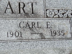


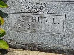
Carl Emmet Lenhart
| Birth | : | 15 Sep 1901 Henry County, Iowa, USA |
| Death | : | 15 Jul 1935 Fairfield, Jefferson County, Iowa, USA |
| Burial | : | Evergreen Cemetery, Fairfield, Jefferson County, USA |
| Coordinate | : | 41.0138600, -91.9562100 |
| Plot | : | 3rd.067 |
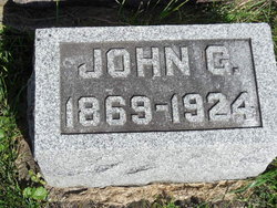
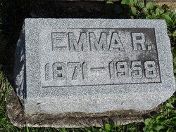
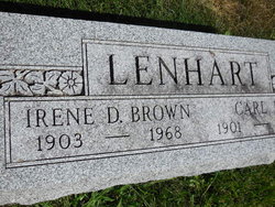
| Description | : | Son of John Godfred Lenhart and Emma Rose Ort Lenhart. Husband of Irene Davis Lenhart, married on November 24, 1932; five years after Carl's death she remarried on October 26, 1940 to Hugh Brown,but Irene is buried with Carl Lenhart in his Lenhart family plot in Evergreen cemetery. ---------------- Fairfield Ia. Daily Ledger Monday July 15, 1935 Pg. 5 Col. 3 CARL LENHART DIES; FUNERAL IS WEDNESDAY Young Jefferson County Farmer Underwent Emergency Operation Carl E. Lenhart, 33, well known Jefferson county farmer, died at 4:55 a.m. today at the Jefferson county hospital after undergoing an emergency appendix operation, Saturday noon. He was taken ill... Read More |
frequently asked questions (FAQ):
-
Where is Carl Emmet Lenhart's memorial?
Carl Emmet Lenhart's memorial is located at: Evergreen Cemetery, Fairfield, Jefferson County, USA.
-
When did Carl Emmet Lenhart death?
Carl Emmet Lenhart death on 15 Jul 1935 in Fairfield, Jefferson County, Iowa, USA
-
Where are the coordinates of the Carl Emmet Lenhart's memorial?
Latitude: 41.0138600
Longitude: -91.9562100
Family Members:
Parent
Spouse
Siblings

Flowers:


Nearby Cemetories:
1. Evergreen Cemetery
Fairfield, Jefferson County, USA
Coordinate: 41.0138600, -91.9562100
2. Old Fairfield Cemetery
Fairfield, Jefferson County, USA
Coordinate: 41.0148000, -91.9598000
3. Memorial Lawn Cemetery
Fairfield, Jefferson County, USA
Coordinate: 41.0068000, -91.9805000
4. Switzer Cemetery
Fairfield, Jefferson County, USA
Coordinate: 41.0368996, -91.9096985
5. Bradshaw Cemetery
Jefferson County, USA
Coordinate: 40.9766998, -91.9032974
6. Roth Cemetery
Fairfield, Jefferson County, USA
Coordinate: 40.9589005, -91.9574966
7. Bethesda Cemetery
Fairfield, Jefferson County, USA
Coordinate: 41.0019000, -91.8796000
8. Smith Family Cemetery
Libertyville, Jefferson County, USA
Coordinate: 40.9972416, -92.0362857
9. Wheeler Cemetery
Jefferson County, USA
Coordinate: 41.0797000, -91.9185500
10. Galliher Cemetery
Glasgow, Jefferson County, USA
Coordinate: 40.9666892, -91.8835038
11. Upper Richwoods Cemetery
Salina, Jefferson County, USA
Coordinate: 41.0602989, -91.8807983
12. Jefferson County Poor Farm Cemetery
Libertyville, Jefferson County, USA
Coordinate: 40.9416900, -91.9996200
13. Perlee Cemetery
Perlee, Jefferson County, USA
Coordinate: 41.0805750, -91.8993380
14. Pattison Cemetery
Fairfield, Jefferson County, USA
Coordinate: 40.9444008, -91.9049988
15. Moorman Cemetery
Fairfield, Jefferson County, USA
Coordinate: 41.0452995, -92.0622025
16. Wright Cemetery
Fairfield, Jefferson County, USA
Coordinate: 40.9524000, -91.8728000
17. Antioch Cemetery
Fairfield, Jefferson County, USA
Coordinate: 41.1002998, -91.9147034
18. Moyer Cemetery
Fairfield, Jefferson County, USA
Coordinate: 41.1046982, -91.9330978
19. Cumberland Cemetery
Jefferson County, USA
Coordinate: 40.9248000, -91.9903000
20. Gregg Cemetery
Jefferson County, USA
Coordinate: 41.0078011, -92.0811005
21. Salina Cemetery
Salina, Jefferson County, USA
Coordinate: 41.0419006, -91.8330994
22. McCleary Cemetery
Jefferson County, USA
Coordinate: 40.9892006, -92.0805969
23. Brooks Cemetery
Jefferson County, USA
Coordinate: 41.0635986, -92.0693970
24. Thompson Cemetery
Jefferson County, USA
Coordinate: 40.9155998, -91.9772034