
Carl Goetlieb Weller
| Birth | : | 1 Sep 1861 Germany |
| Death | : | 1953 Clayton, Clayton County, Iowa, USA |
| Burial | : | National Cemetery, National, Clayton County, USA |
| Coordinate | : | 42.9536018, -91.2902985 |
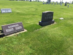
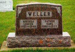
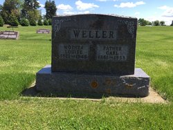
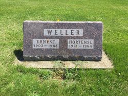
| Description | : | Carl Goetlieb Weller was born in Hoffenlimbach, Wurttemberg, Germany, a son of Johannas Weller and Catharinae Burbach. Carl received his education and religious training in Germany and was baptized and confirmed in the Lutheran church there. He immigrated to America and arrived here on his twenty-second birthday in 1882. He worked as a hired hand on a farm and then operated his own farm. On January 5, 1888, Carl married Louise Reinhardt. Carl and Louise had children: Amel, Elmer, Hilda, Alfreda and Ernest. |
frequently asked questions (FAQ):
-
Where is Carl Goetlieb Weller's memorial?
Carl Goetlieb Weller's memorial is located at: National Cemetery, National, Clayton County, USA.
-
When did Carl Goetlieb Weller death?
Carl Goetlieb Weller death on 1953 in Clayton, Clayton County, Iowa, USA
-
Where are the coordinates of the Carl Goetlieb Weller's memorial?
Latitude: 42.9536018
Longitude: -91.2902985
Family Members:
Spouse
Children
Flowers:


Nearby Cemetories:
1. National Cemetery
National, Clayton County, USA
Coordinate: 42.9536018, -91.2902985
2. Giard Cemetery
Farmersburg, Clayton County, USA
Coordinate: 42.9933014, -91.3080978
3. Bismark Cemetery
Farmersburg, Clayton County, USA
Coordinate: 42.9790000, -91.3500000
4. Farmersburg-Wagner Cemetery
Farmersburg, Clayton County, USA
Coordinate: 42.9481010, -91.3700027
5. Eastman Cemetery
McGregor, Clayton County, USA
Coordinate: 43.0010000, -91.2190000
6. Clayton Center Cemetery
Clayton Center, Clayton County, USA
Coordinate: 42.8841705, -91.3225021
7. Zion Lutheran Cemetery
Clayton Center, Clayton County, USA
Coordinate: 42.8841705, -91.3249969
8. County Home Cemetery
Clayton Center, Clayton County, USA
Coordinate: 42.8916702, -91.3499985
9. Railroad Employee Cemetery
Giard, Clayton County, USA
Coordinate: 43.0305395, -91.3140229
10. Norwegian Church Cemetery
McGregor, Clayton County, USA
Coordinate: 42.9644400, -91.1764100
11. First Evangelical Lutheran Church Cemetery
McGregor, Clayton County, USA
Coordinate: 42.9718000, -91.1760000
12. Colony Catholic Cemetery (Defunct)
Read Township, Clayton County, USA
Coordinate: 42.8830000, -91.3580000
13. Moody Cemetery
McGregor, Clayton County, USA
Coordinate: 43.0030594, -91.1886063
14. Buell Park Cemetery
Mendon Township, Clayton County, USA
Coordinate: 43.0168226, -91.1999590
15. Garnavillo Community Cemetery
Garnavillo, Clayton County, USA
Coordinate: 42.8656000, -91.2422100
16. Garnavillo Cemetery
Garnavillo, Clayton County, USA
Coordinate: 42.8660300, -91.2390100
17. Saint Joseph Cemetery
Garnavillo, Clayton County, USA
Coordinate: 42.8628006, -91.2502975
18. Walton Cemetery
McGregor, Clayton County, USA
Coordinate: 43.0216270, -91.1909350
19. Gooding Cemetery
Wagner Township, Clayton County, USA
Coordinate: 42.9869490, -91.4191570
20. Pleasant Grove Cemetery
McGregor, Clayton County, USA
Coordinate: 43.0266991, -91.1949997
21. Saint Marys Catholic Church Cemetery
McGregor, Clayton County, USA
Coordinate: 43.0213735, -91.1834632
22. Norway Lutheran Church Cemetery
Saint Olaf, Clayton County, USA
Coordinate: 42.9352798, -91.4302826
23. Clayton Cemetery
Clayton, Clayton County, USA
Coordinate: 42.9043999, -91.1641998
24. Saint Wenceslaus Cemetery
McGregor, Clayton County, USA
Coordinate: 43.0593987, -91.3142014