
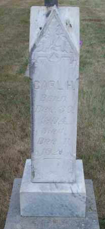
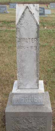
Carl H Werner
| Birth | : | 30 Dec 1904 |
| Death | : | 11 Dec 1921 Pierce County, Nebraska, USA |
| Burial | : | Grove Cemetery, Grove, Vale of White Horse District, England |
| Coordinate | : | 51.6160002, -1.4299708 |
frequently asked questions (FAQ):
-
Where is Carl H Werner's memorial?
Carl H Werner's memorial is located at: Grove Cemetery, Grove, Vale of White Horse District, England.
-
When did Carl H Werner death?
Carl H Werner death on 11 Dec 1921 in Pierce County, Nebraska, USA
-
Where are the coordinates of the Carl H Werner's memorial?
Latitude: 51.6160002
Longitude: -1.4299708
Family Members:
Parent

Siblings
Flowers:


Nearby Cemetories:
1. Grove Cemetery
Grove, Vale of White Horse District, England
Coordinate: 51.6160002, -1.4299708
2. St. John the Baptist Churchyard
Grove, Vale of White Horse District, England
Coordinate: 51.6112858, -1.4204966
3. Strict Baptist Chapel
Grove, Vale of White Horse District, England
Coordinate: 51.6051668, -1.4219236
4. St. James The Great Churchyard
Denchworth, Vale of White Horse District, England
Coordinate: 51.6229400, -1.4507800
5. St. James The Great Churchyard
West Hanney, Vale of White Horse District, England
Coordinate: 51.6325030, -1.4144360
6. Wantage Baptist Church
Wantage, Vale of White Horse District, England
Coordinate: 51.5892190, -1.4270540
7. St. Peter and Paul Churchyard
Wantage, Vale of White Horse District, England
Coordinate: 51.5886860, -1.4284970
8. St. Nicholas Churchyard
East Challow, Vale of White Horse District, England
Coordinate: 51.5919480, -1.4518960
9. St Mary's Churchyard
Lyford, Vale of White Horse District, England
Coordinate: 51.6456433, -1.4371256
10. Vicarage Hill Cemetery
East Challow, Vale of White Horse District, England
Coordinate: 51.5877810, -1.4512553
11. Chain Hill Cemetery
Wantage, Vale of White Horse District, England
Coordinate: 51.5843868, -1.4217107
12. St. Peter Churchyard
Charney Bassett, Vale of White Horse District, England
Coordinate: 51.6472944, -1.4501905
13. St. Laurence Churchyard
West Challow, Vale of White Horse District, England
Coordinate: 51.5920920, -1.4708930
14. All Saints Churchyard
Goosey, Vale of White Horse District, England
Coordinate: 51.6225320, -1.4865200
15. East Lockinge All Souls Church Cemetery
Lockinge, Vale of White Horse District, England
Coordinate: 51.5846900, -1.3899900
16. Holy Trinity Churchyard
Ardington, Vale of White Horse District, England
Coordinate: 51.5920530, -1.3784550
17. East Lockinge War Memorial
Wantage, Vale of White Horse District, England
Coordinate: 51.5844426, -1.3883416
18. St. Andrew Churchyard
Letcombe Regis, Vale of White Horse District, England
Coordinate: 51.5758900, -1.4527800
19. St. Mary's Churchyard
Childrey, Vale of White Horse District, England
Coordinate: 51.5876500, -1.4818600
20. All Saints Churchyard
Wantage, Vale of White Horse District, England
Coordinate: 51.5827496, -1.3822236
21. South Oxfordshire Memorial Park and Crematorium
Garford, Vale of White Horse District, England
Coordinate: 51.6535980, -1.3767840
22. Holy Trinity Churchyard
West Hendred, Vale of White Horse District, England
Coordinate: 51.5916030, -1.3556760
23. St Deny's Churchyard
Stanford-in-the-Vale, Vale of White Horse District, England
Coordinate: 51.6399960, -1.5062800
24. Holy Cross Churchyard
Sparsholt, Vale of White Horse District, England
Coordinate: 51.5857220, -1.5008460