

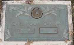
Carl R “Toot” Oakleaf
| Birth | : | 17 Feb 1929 Newark, Licking County, Ohio, USA |
| Death | : | 22 Aug 2019 Heath, Licking County, Ohio, USA |
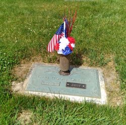
| Burial | : | Oakland Cemetery, Monticello, Drew County, USA |
| Coordinate | : | 33.6342010, -91.7981033 |
| Description | : | Son of the late C. Harry and Erma (Winegardner) Oakleaf. He served in the United States Army during Korean War from 1950-1952. He was the owner of Oaks Furniture for 42 years before retiring. He participated in and won several state Euchre tournaments. He was a member of the Zerger Hall – Sunrise Manor Group; Licking County Aging Program, Lancaster Moose Lodge #95, AMVETS Post #51, and was a Disabled American Veterans Life Member. In addition to his parents, he was preceded in death by two brothers, Ralph Oakleaf and Kenneth Oakleaf. He is survived by his brother, Ron... Read More |
frequently asked questions (FAQ):
-
Where is Carl R “Toot” Oakleaf's memorial?
Carl R “Toot” Oakleaf's memorial is located at: Oakland Cemetery, Monticello, Drew County, USA.
-
When did Carl R “Toot” Oakleaf death?
Carl R “Toot” Oakleaf death on 22 Aug 2019 in Heath, Licking County, Ohio, USA
-
Where are the coordinates of the Carl R “Toot” Oakleaf's memorial?
Latitude: 33.6342010
Longitude: -91.7981033
Family Members:
Parent

Siblings

Flowers:


Nearby Cemetories:
1. Oakland Cemetery
Monticello, Drew County, USA
Coordinate: 33.6342010, -91.7981033
2. Kennedy Boulevard Cemetery
Monticello, Drew County, USA
Coordinate: 33.6395700, -91.7756200
3. Manees Cemetery
Drew County, USA
Coordinate: 33.6333100, -91.8243100
4. Rough and Ready Cemetery
Monticello, Drew County, USA
Coordinate: 33.6082993, -91.7891998
5. Gaster Hill Cemetery
Drew County, USA
Coordinate: 33.6591988, -91.8110962
6. Rose Hill Cemetery
Monticello, Drew County, USA
Coordinate: 33.6749992, -91.7827988
7. Rose Hill Cemetery
Meroney, Lincoln County, USA
Coordinate: 33.6753740, -91.7828590
8. Wells Cemetery
Monticello, Drew County, USA
Coordinate: 33.6567980, -91.8438550
9. Priest Cemetery
Monticello, Drew County, USA
Coordinate: 33.6088080, -91.7485850
10. Veasey Cemetery
Drew County, USA
Coordinate: 33.6088220, -91.7485680
11. Brooks Chapel Cemetery
Monticello, Drew County, USA
Coordinate: 33.5959080, -91.8479410
12. Shady Grove AME Cemetery
Cominto, Drew County, USA
Coordinate: 33.6460991, -91.7316971
13. Union Ridge Cemetery #2
Monticello, Drew County, USA
Coordinate: 33.5786500, -91.7823300
14. Union Ridge Cemetery #1
Monticello, Drew County, USA
Coordinate: 33.5766100, -91.7817100
15. Mount Zion African Methodist Episcopal Church Ceme
Monticello, Drew County, USA
Coordinate: 33.6892960, -91.7367250
16. Zion Hill
Monticello, Drew County, USA
Coordinate: 33.6383080, -91.7027281
17. Torian Cemetery
Drew County, USA
Coordinate: 33.6758003, -91.8927994
18. Old Saline Church Cemetery
Wilmar, Drew County, USA
Coordinate: 33.6197014, -91.9083023
19. Andrews Chapel Cemetery
Barkada, Drew County, USA
Coordinate: 33.6716995, -91.9021988
20. Campground Cemetery
Monticello, Drew County, USA
Coordinate: 33.7292890, -91.8218650
21. Bethel Cemetery
Drew County, USA
Coordinate: 33.6755981, -91.9119034
22. Baker Cemetery
Drew County, USA
Coordinate: 33.5318985, -91.7686005
23. Green Hill Cemetery
Green Hill, Drew County, USA
Coordinate: 33.5647011, -91.8972015
24. Enon Cemetery
Enon, Drew County, USA
Coordinate: 33.5882988, -91.6789017