
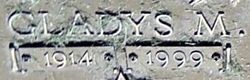
| Birth | : | 7 May 1932 Lawrence, Douglas County, Kansas, USA |
| Death | : | 18 Nov 2014 Eudora Township, Douglas County, Kansas, USA |
| Burial | : | Memorial Park Cemetery, Lawrence, Douglas County, USA |
| Coordinate | : | 38.9552994, -95.2153015 |
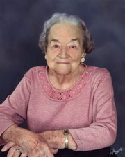
| Description | : | Funeral services for Carol Joyce Belles, 82, Lawrence, will be 2 pm Monday, November 24, 2014, at Rumsey-Yost Funeral Home. Burial will follow at Memorial Park Cemetery. Mrs. Belles died Tuesday, November 18, 2014, at Medicalodges, Eudora. She was born May 7, 1932, in Lawrence, KS, the daughter of Alvin E and Lillie M (Smith) Bond. She graduated from Eudora High School. Carol was a Girl Scout growing up and later became a scout leader. Carol married Howard L Belles in Baldwin City on June 25, 1950, he proceeded her in death on August... Read More |
frequently asked questions (FAQ):
-
Where is Carol Joyce Bond Belles's memorial?
Carol Joyce Bond Belles's memorial is located at: Memorial Park Cemetery, Lawrence, Douglas County, USA.
-
When did Carol Joyce Bond Belles death?
Carol Joyce Bond Belles death on 18 Nov 2014 in Eudora Township, Douglas County, Kansas, USA
-
Where are the coordinates of the Carol Joyce Bond Belles's memorial?
Latitude: 38.9552994
Longitude: -95.2153015
Family Members:
Parent

Spouse
Siblings
Flowers:


Nearby Cemetories:
1. Memorial Park Cemetery
Lawrence, Douglas County, USA
Coordinate: 38.9552994, -95.2153015
2. Mount Calvary Catholic Cemetery
Lawrence, Douglas County, USA
Coordinate: 38.9580002, -95.2139969
3. Oak Hill Cemetery
Lawrence, Douglas County, USA
Coordinate: 38.9589005, -95.2118988
4. Trinity Episcopal Church Columbarium
Lawrence, Douglas County, USA
Coordinate: 38.9653893, -95.2373886
5. Saint Johns Catholic Cemetery
Douglas County, USA
Coordinate: 38.9437900, -95.1919600
6. Dyche Hall Natural History Museum
Lawrence, Douglas County, USA
Coordinate: 38.9584800, -95.2434800
7. Haskell Cemetery
Lawrence, Douglas County, USA
Coordinate: 38.9353790, -95.2284241
8. Franklin Cemetery
Douglas County, USA
Coordinate: 38.9437523, -95.1869431
9. Pioneer Cemetery
Lawrence, Douglas County, USA
Coordinate: 38.9528008, -95.2611008
10. First Presbyterian Church Memorial Garden
Lawrence, Douglas County, USA
Coordinate: 38.9414900, -95.2641600
11. County Poor Farm Cemetery
Douglas County, USA
Coordinate: 38.9119400, -95.2214600
12. Kennedy Cemetery
Douglas County, USA
Coordinate: 38.9112900, -95.2269200
13. Maple Grove Cemetery
Lawrence, Douglas County, USA
Coordinate: 39.0018997, -95.2316971
14. Adams Cemetery
Douglas County, USA
Coordinate: 38.9955400, -95.2509100
15. Blue Mound Cemetery
Lawrence, Douglas County, USA
Coordinate: 38.9046600, -95.1865400
16. Davis Cemetery
Lawrence, Douglas County, USA
Coordinate: 38.9722500, -95.2831100
17. Marshall Cemetery
Douglas County, USA
Coordinate: 38.9040800, -95.2446700
18. Dutton Cemetery
Douglas County, USA
Coordinate: 38.8989800, -95.2790600
19. Luckan Family Cemetery
Fall Leaf, Leavenworth County, USA
Coordinate: 38.9808500, -95.1128000
20. Corpus Christi Catholic Church Columbarium
Lawrence, Douglas County, USA
Coordinate: 38.9572250, -95.3238450
21. Cemetery Beni Israel
Eudora, Douglas County, USA
Coordinate: 38.9280128, -95.1122208
22. Lyon Family Cemetery
Lawrence, Douglas County, USA
Coordinate: 38.9877440, -95.3166530
23. Richland Cemetery
Lawrence, Douglas County, USA
Coordinate: 38.8768997, -95.2630997
24. Southwest City Cemetery
Eudora, Douglas County, USA
Coordinate: 38.9334800, -95.1070300