
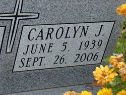
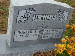
Carolyn June Allee McKillip
| Birth | : | 5 Jun 1939 California, Moniteau County, Missouri, USA |
| Death | : | 26 Sep 2006 Lawrence, Douglas County, Kansas, USA |
| Burial | : | Mount Calvary Catholic Cemetery, Lawrence, Douglas County, USA |
| Coordinate | : | 38.9580002, -95.2139969 |
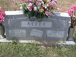
| Description | : | Services for Carolyn June McKillip, 67, Lawrence, will be at 10 a.m. Friday at Corpus Christi Catholic Church in Lawrence. Private burial will be at a later date in Mount Calvary Cemetery in Lawrence. Mrs. McKillip died Tuesday, Sept. 26, 2006, at her home. She was born June 5, 1939, in California, Mo., the daughter of Walter and Dixie Gist Allee. She attended public schools in California, Mo. She worked at several companies, including University of Missouri-Kansas City and Metzler Insurance, in Kansas City, Mo., for 40 years. She married Donald McKillip on July 4, 1998, in Kansas City, Mo. He survives, of the... Read More |
frequently asked questions (FAQ):
-
Where is Carolyn June Allee McKillip's memorial?
Carolyn June Allee McKillip's memorial is located at: Mount Calvary Catholic Cemetery, Lawrence, Douglas County, USA.
-
When did Carolyn June Allee McKillip death?
Carolyn June Allee McKillip death on 26 Sep 2006 in Lawrence, Douglas County, Kansas, USA
-
Where are the coordinates of the Carolyn June Allee McKillip's memorial?
Latitude: 38.9580002
Longitude: -95.2139969
Family Members:
Parent
Flowers:


Nearby Cemetories:
1. Mount Calvary Catholic Cemetery
Lawrence, Douglas County, USA
Coordinate: 38.9580002, -95.2139969
2. Oak Hill Cemetery
Lawrence, Douglas County, USA
Coordinate: 38.9589005, -95.2118988
3. Memorial Park Cemetery
Lawrence, Douglas County, USA
Coordinate: 38.9552994, -95.2153015
4. Trinity Episcopal Church Columbarium
Lawrence, Douglas County, USA
Coordinate: 38.9653893, -95.2373886
5. Saint Johns Catholic Cemetery
Douglas County, USA
Coordinate: 38.9437900, -95.1919600
6. Dyche Hall Natural History Museum
Lawrence, Douglas County, USA
Coordinate: 38.9584800, -95.2434800
7. Haskell Cemetery
Lawrence, Douglas County, USA
Coordinate: 38.9353790, -95.2284241
8. Franklin Cemetery
Douglas County, USA
Coordinate: 38.9437523, -95.1869431
9. Pioneer Cemetery
Lawrence, Douglas County, USA
Coordinate: 38.9528008, -95.2611008
10. First Presbyterian Church Memorial Garden
Lawrence, Douglas County, USA
Coordinate: 38.9414900, -95.2641600
11. Maple Grove Cemetery
Lawrence, Douglas County, USA
Coordinate: 39.0018997, -95.2316971
12. County Poor Farm Cemetery
Douglas County, USA
Coordinate: 38.9119400, -95.2214600
13. Adams Cemetery
Douglas County, USA
Coordinate: 38.9955400, -95.2509100
14. Kennedy Cemetery
Douglas County, USA
Coordinate: 38.9112900, -95.2269200
15. Davis Cemetery
Lawrence, Douglas County, USA
Coordinate: 38.9722500, -95.2831100
16. Blue Mound Cemetery
Lawrence, Douglas County, USA
Coordinate: 38.9046600, -95.1865400
17. Marshall Cemetery
Douglas County, USA
Coordinate: 38.9040800, -95.2446700
18. Dutton Cemetery
Douglas County, USA
Coordinate: 38.8989800, -95.2790600
19. Luckan Family Cemetery
Fall Leaf, Leavenworth County, USA
Coordinate: 38.9808500, -95.1128000
20. Cemetery Beni Israel
Eudora, Douglas County, USA
Coordinate: 38.9280128, -95.1122208
21. Lyon Family Cemetery
Lawrence, Douglas County, USA
Coordinate: 38.9877440, -95.3166530
22. Corpus Christi Catholic Church Columbarium
Lawrence, Douglas County, USA
Coordinate: 38.9572250, -95.3238450
23. Southwest City Cemetery
Eudora, Douglas County, USA
Coordinate: 38.9334800, -95.1070300
24. Richland Cemetery
Lawrence, Douglas County, USA
Coordinate: 38.8768997, -95.2630997