
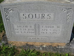
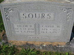
Carrie May Shaffer Sours
| Birth | : | 9 Apr 1879 Page County, Virginia, USA |
| Death | : | 4 Oct 1972 Lynchburg City, Virginia, USA |
| Burial | : | Seafarers Haven Cemetery, Drayden, St. Mary's County, USA |
| Coordinate | : | 38.1589928, -76.5002670 |
| Description | : | Mrs. Carrie Shaffer Sours, 93, of Lynchburg and a native of Luray, died Wednesday at the Odd Fellows Home in Lynchburg. Mrs. Sours was born April 9, 1879 in Luray and was a daughter of Emmanuel and Catherine Shaffer. She was a member of Holy Trinity Lutheran Church in Lynchburg and was the widow of Jacob B. Sours. Surviving are a brother, Edward Shaffer, pf Uhrichsville, Ohio, and a sister, Mrs. Mary Bradley of Luray. The funeral will be conducted at 11 a.m. Saturday at Morning Star Lutheran Church by the Rev. Russell J. Crouse. Burial will be in the church cemetery. The family will... Read More |
frequently asked questions (FAQ):
-
Where is Carrie May Shaffer Sours's memorial?
Carrie May Shaffer Sours's memorial is located at: Seafarers Haven Cemetery, Drayden, St. Mary's County, USA.
-
When did Carrie May Shaffer Sours death?
Carrie May Shaffer Sours death on 4 Oct 1972 in Lynchburg City, Virginia, USA
-
Where are the coordinates of the Carrie May Shaffer Sours's memorial?
Latitude: 38.1589928
Longitude: -76.5002670
Family Members:
Parent
Spouse
Siblings
Flowers:


Nearby Cemetories:
1. Seafarers Haven Cemetery
Drayden, St. Mary's County, USA
Coordinate: 38.1589928, -76.5002670
2. Saint George's Roman Catholic Cemetery
Valley Lee, St. Mary's County, USA
Coordinate: 38.1940842, -76.5042114
3. Bethesda United Methodist Cemetery
Valley Lee, St. Mary's County, USA
Coordinate: 38.1981812, -76.4946976
4. Saint George's Poplar Hill Episcopal Cemetery
Valley Lee, St. Mary's County, USA
Coordinate: 38.1954689, -76.5212631
5. Saint Marks UAME Cemetery
Valley Lee, St. Mary's County, USA
Coordinate: 38.1989200, -76.4957000
6. First Saints Community Church Cemetery
Saint George Island, St. Mary's County, USA
Coordinate: 38.1207008, -76.4813004
7. Saint Luke UAME Cemetery
Saint George Island, St. Mary's County, USA
Coordinate: 38.1174300, -76.4815800
8. Saint Francis Xavier Chapel Cemetery
Saint George Island, St. Mary's County, USA
Coordinate: 38.1170600, -76.4815220
9. Old Community Cemetery
Saint George Island, St. Mary's County, USA
Coordinate: 38.1169140, -76.4814040
10. Trinity Church Cemetery
Saint Marys City, St. Mary's County, USA
Coordinate: 38.1874084, -76.4350967
11. Saint Marys College of Maryland Burial Ground
Saint Marys City, St. Mary's County, USA
Coordinate: 38.1866074, -76.4310684
12. Saint Ignatius Church Cemetery
Saint Inigoes, St. Mary's County, USA
Coordinate: 38.1501503, -76.4231491
13. Chapel Field
Saint Marys City, St. Mary's County, USA
Coordinate: 38.1831370, -76.4281080
14. Great Brick Chapel
Saint Marys City, St. Mary's County, USA
Coordinate: 38.1832450, -76.4278400
15. Slovack Cemetery
Saint Marys City, St. Mary's County, USA
Coordinate: 38.1873817, -76.4246368
16. Glen Mary Farms Cemetery (Defunct)
Park Hall, St. Mary's County, USA
Coordinate: 38.2171740, -76.4589480
17. Father Andrew White Monument
Saint Marys City, St. Mary's County, USA
Coordinate: 38.1988700, -76.4281500
18. Saint Marys Youth Memorial Park
Great Mills, St. Mary's County, USA
Coordinate: 38.2367477, -76.4956131
19. Holy Face Cemetery
Great Mills, St. Mary's County, USA
Coordinate: 38.2406006, -76.5096970
20. Park Hall True Holiness Church Cemetery
Park Hall, St. Mary's County, USA
Coordinate: 38.2177315, -76.4247665
21. Mount Zion United Methodist Church Cemetery
Saint Inigoes, St. Mary's County, USA
Coordinate: 38.1444817, -76.3890228
22. Saint James Catholic Cemetery
Lexington Park, St. Mary's County, USA
Coordinate: 38.1985207, -76.3939438
23. Saint Peter Claver Catholic Church Cemetery
Saint Inigoes, St. Mary's County, USA
Coordinate: 38.1316719, -76.3802338
24. First Missionary Baptist Church Cemetery
Lexington Park, St. Mary's County, USA
Coordinate: 38.2455606, -76.4298946