
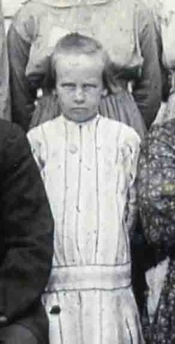
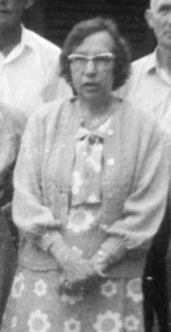


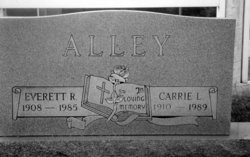
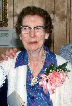
Carrie Reed Lineberry Alley
| Birth | : | 24 Apr 1910 Carroll County, Virginia, USA |
| Death | : | 8 Jul 1989 Fort Walton Beach, Okaloosa County, Florida, USA |
| Burial | : | Rose Hill Cemetery, Oxford, City of Oxford, England |
| Coordinate | : | 51.7320960, -1.2254070 |
| Description | : | The Carroll News, Wednesday, July 19, 1989 Page 2 Carrie L. Alley Carrie Lineberry Alley, 79, died July 8,1989, in Ft. Walton Beach, Fla., after a long-term illness. A resident of Ft. Walton Beach, Fla. for the past three years, she was a native of Galax. She was the widow of Everett R. Alley and a long time resident of New London, N.C. One of nine children born to Floyd M. and Cara Coulson Lineberry, she is survived by her son, Eugene N. Alley, two grandchildren, all of Niceville, Fla.; sister, Cassie L. Quesenberry, Galax and numerous nieces and nephews. Graveside services were held... Read More |
frequently asked questions (FAQ):
-
Where is Carrie Reed Lineberry Alley's memorial?
Carrie Reed Lineberry Alley's memorial is located at: Rose Hill Cemetery, Oxford, City of Oxford, England.
-
When did Carrie Reed Lineberry Alley death?
Carrie Reed Lineberry Alley death on 8 Jul 1989 in Fort Walton Beach, Okaloosa County, Florida, USA
-
Where are the coordinates of the Carrie Reed Lineberry Alley's memorial?
Latitude: 51.7320960
Longitude: -1.2254070
Family Members:
Parent
Spouse
Siblings

Flowers:


Nearby Cemetories:
1. Rose Hill Cemetery
Oxford, City of Oxford, England
Coordinate: 51.7320960, -1.2254070
2. St. James Churchyard
Cowley, City of Oxford, England
Coordinate: 51.7305878, -1.2202638
3. St Mary the Virgin Churchyard
Iffley, City of Oxford, England
Coordinate: 51.7273590, -1.2381680
4. St Mary and St Nicholas Churchyard
Littlemore, City of Oxford, England
Coordinate: 51.7210753, -1.2232272
5. Littlemore Chapel
Littlemore, City of Oxford, England
Coordinate: 51.7208320, -1.2270330
6. St Mary and St John Church
Oxford, City of Oxford, England
Coordinate: 51.7452501, -1.2314021
7. Greyfriars
Oxford, City of Oxford, England
Coordinate: 51.7437920, -1.2401460
8. St. Aldate's Churchyard
Oxford, City of Oxford, England
Coordinate: 51.7497900, -1.2118500
9. St. Andrew's Churchyard
Sandford-on-Thames, South Oxfordshire District, England
Coordinate: 51.7121430, -1.2289060
10. St Ignatius’ Chapel
Oxford, City of Oxford, England
Coordinate: 51.7503160, -1.2396720
11. St. Clements Churchyard
Oxford, City of Oxford, England
Coordinate: 51.7527790, -1.2369920
12. St Laurence Churchyard
South Hinksey, Vale of White Horse District, England
Coordinate: 51.7319218, -1.2635270
13. St Matthews Church
Oxford, City of Oxford, England
Coordinate: 51.7442200, -1.2585480
14. Magdalen College Chapel
Oxford, City of Oxford, England
Coordinate: 51.7519830, -1.2469820
15. Merton College chapel
Oxford, City of Oxford, England
Coordinate: 51.7510500, -1.2526620
16. Corpus Christi College Chapel
Oxford, City of Oxford, England
Coordinate: 51.7507010, -1.2534236
17. Christ Church Cathedral
Oxford, City of Oxford, England
Coordinate: 51.7500620, -1.2547160
18. Oriel College Ante-Chapel
Oxford, City of Oxford, England
Coordinate: 51.7512420, -1.2531940
19. University College Chapel
Oxford, City of Oxford, England
Coordinate: 51.7522100, -1.2521700
20. Queens College Chapel
Oxford, City of Oxford, England
Coordinate: 51.7532340, -1.2506990
21. St Peter-in-the-East Churchyard
Oxford, City of Oxford, England
Coordinate: 51.7536111, -1.2500000
22. New College
Oxford, City of Oxford, England
Coordinate: 51.7543090, -1.2515310
23. St. Cross Churchyard
Holywell, City of Oxford, England
Coordinate: 51.7558380, -1.2479690
24. University Church of St Mary the Virgin
Oxford, City of Oxford, England
Coordinate: 51.7523990, -1.2556000