
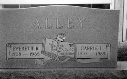
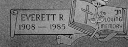
Everett Raymond Alley
| Birth | : | 31 Jan 1908 Carroll County, Virginia, USA |
| Death | : | 20 Jun 1985 New London, Stanly County, North Carolina, USA |
| Burial | : | Rose Hill Cemetery, Oxford, City of Oxford, England |
| Coordinate | : | 51.7320960, -1.2254070 |
| Description | : | The Gazette, Wednesday, June 26, 1985, Page 7A Everett Raymond Alley, 77, of Rt. 1, Box 97 (Highway 52 North), New London, N.C., died Thursday, June 20, 1985, at his home after a long-term illness. He was born in Carroll County Jan. 31, 1908, to Samuel B. Alley and Susan Smythers Alley. He was a retired supervisor with Cannon Mills. He was a member of Prospect Baptist Church where he was a former deacon, and a lifetime member of Moose Lodge No. 733, Galax. Surviving are his wife, Carry Lineberry Alley; one son, Eugene Alley, Niceville, Fla.; one brother,... Read More |
frequently asked questions (FAQ):
-
Where is Everett Raymond Alley's memorial?
Everett Raymond Alley's memorial is located at: Rose Hill Cemetery, Oxford, City of Oxford, England.
-
When did Everett Raymond Alley death?
Everett Raymond Alley death on 20 Jun 1985 in New London, Stanly County, North Carolina, USA
-
Where are the coordinates of the Everett Raymond Alley's memorial?
Latitude: 51.7320960
Longitude: -1.2254070
Family Members:
Parent
Spouse
Siblings

Flowers:


Nearby Cemetories:
1. Rose Hill Cemetery
Oxford, City of Oxford, England
Coordinate: 51.7320960, -1.2254070
2. St. James Churchyard
Cowley, City of Oxford, England
Coordinate: 51.7305878, -1.2202638
3. St Mary the Virgin Churchyard
Iffley, City of Oxford, England
Coordinate: 51.7273590, -1.2381680
4. St Mary and St Nicholas Churchyard
Littlemore, City of Oxford, England
Coordinate: 51.7210753, -1.2232272
5. Littlemore Chapel
Littlemore, City of Oxford, England
Coordinate: 51.7208320, -1.2270330
6. St Mary and St John Church
Oxford, City of Oxford, England
Coordinate: 51.7452501, -1.2314021
7. Greyfriars
Oxford, City of Oxford, England
Coordinate: 51.7437920, -1.2401460
8. St. Aldate's Churchyard
Oxford, City of Oxford, England
Coordinate: 51.7497900, -1.2118500
9. St. Andrew's Churchyard
Sandford-on-Thames, South Oxfordshire District, England
Coordinate: 51.7121430, -1.2289060
10. St Ignatius’ Chapel
Oxford, City of Oxford, England
Coordinate: 51.7503160, -1.2396720
11. St. Clements Churchyard
Oxford, City of Oxford, England
Coordinate: 51.7527790, -1.2369920
12. St Laurence Churchyard
South Hinksey, Vale of White Horse District, England
Coordinate: 51.7319218, -1.2635270
13. St Matthews Church
Oxford, City of Oxford, England
Coordinate: 51.7442200, -1.2585480
14. Magdalen College Chapel
Oxford, City of Oxford, England
Coordinate: 51.7519830, -1.2469820
15. Merton College chapel
Oxford, City of Oxford, England
Coordinate: 51.7510500, -1.2526620
16. Corpus Christi College Chapel
Oxford, City of Oxford, England
Coordinate: 51.7507010, -1.2534236
17. Christ Church Cathedral
Oxford, City of Oxford, England
Coordinate: 51.7500620, -1.2547160
18. Oriel College Ante-Chapel
Oxford, City of Oxford, England
Coordinate: 51.7512420, -1.2531940
19. University College Chapel
Oxford, City of Oxford, England
Coordinate: 51.7522100, -1.2521700
20. Queens College Chapel
Oxford, City of Oxford, England
Coordinate: 51.7532340, -1.2506990
21. St Peter-in-the-East Churchyard
Oxford, City of Oxford, England
Coordinate: 51.7536111, -1.2500000
22. New College
Oxford, City of Oxford, England
Coordinate: 51.7543090, -1.2515310
23. St. Cross Churchyard
Holywell, City of Oxford, England
Coordinate: 51.7558380, -1.2479690
24. University Church of St Mary the Virgin
Oxford, City of Oxford, England
Coordinate: 51.7523990, -1.2556000