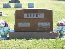
Carrie Tyler Beery
| Birth | : | 28 Oct 1885 |
| Death | : | 11 Oct 1971 |
| Burial | : | Eltham Cemetery, Eltham, South Taranaki District, New Zealand |
| Coordinate | : | -39.4197140, 174.3251260 |
| Plot | : | Section 15, Row 6 |
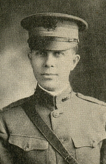
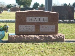
| Description | : | Published in The Rochester Sentinel Monday, October 11, 1971 Carrie Beery Mrs. Carrie BEERY, 85, R.R. 4, Rochester, died at 9:15 a.m. today in Woodlawn hospital. She had been ill since April. Born Oct. 28, 1885, in Stateline, Ind., she was the daughter of Arlaw and Ora [ALLISON TYLER]. Her marriage was June 27, 1907, in the Burton community, to Otto BEERY. He died in 1961. She had resided here 30 years, moving from Attica. She was a member of the Leiters Ford United Methodist church, the Leiters Rebekah lodge and the O.E.S. in Logansport. Surviving are one daughter, Mrs. Norman (Charlotte) HALL, R.R. 4,... Read More |
frequently asked questions (FAQ):
-
Where is Carrie Tyler Beery's memorial?
Carrie Tyler Beery's memorial is located at: Eltham Cemetery, Eltham, South Taranaki District, New Zealand.
-
When did Carrie Tyler Beery death?
Carrie Tyler Beery death on 11 Oct 1971 in
-
Where are the coordinates of the Carrie Tyler Beery's memorial?
Latitude: -39.4197140
Longitude: 174.3251260
Family Members:
Parent
Spouse
Siblings
Children
Flowers:
Nearby Cemetories:
1. Eltham Cemetery
Eltham, South Taranaki District, New Zealand
Coordinate: -39.4197140, 174.3251260
2. Kopuatama Cemetery
Stratford, Stratford District, New Zealand
Coordinate: -39.3364400, 174.3364500
3. Pioneer Cemetery
Stratford, Stratford District, New Zealand
Coordinate: -39.3359800, 174.2929000
4. Te Utinga Urupā
Normanby, South Taranaki District, New Zealand
Coordinate: -39.5330847, 174.2761055
5. Weri Weri Urupa Aotearoa Marae
Okaiawa, South Taranaki District, New Zealand
Coordinate: -39.5190700, 174.2206700
6. Te Ngutu o te Manu Battlesite Memorial
Kapuni, South Taranaki District, New Zealand
Coordinate: -39.4876351, 174.1838147
7. Kaponga Cemetery
Kaponga, South Taranaki District, New Zealand
Coordinate: -39.4312210, 174.1553160
8. Midhirst Old Cemetery
Midhirst, Stratford District, New Zealand
Coordinate: -39.2911920, 174.2731980
9. Midhirst Cemetery
Midhirst, Stratford District, New Zealand
Coordinate: -39.2913640, 174.2724620
10. Waihi Cemetery and Redoubt
Normanby, South Taranaki District, New Zealand
Coordinate: -39.5444930, 174.2566820
11. Okaiawa Cemetery
Okaiawa, South Taranaki District, New Zealand
Coordinate: -39.5310220, 174.2042180
12. Tiwhaiti Urupa (Taiporohenui Marae)
Hāwera, South Taranaki District, New Zealand
Coordinate: -39.5741843, 174.3216120
13. Hāwera Cemetery
Hāwera, South Taranaki District, New Zealand
Coordinate: -39.5897900, 174.2945500
14. Motuawa Urupā Waiokura Marae
Manaia, South Taranaki District, New Zealand
Coordinate: -39.5388010, 174.1438990
15. Ohawe Military Cemetery
Ohawe Beach, South Taranaki District, New Zealand
Coordinate: -39.5835138, 174.2003758
16. Manaia Redoubt
Manaia, South Taranaki District, New Zealand
Coordinate: -39.5461557, 174.1364306
17. Manaia Cemetery
Manaia, South Taranaki District, New Zealand
Coordinate: -39.5575010, 174.1354470
18. Manutahi Cemetery
Manutahi, South Taranaki District, New Zealand
Coordinate: -39.6594677, 174.3924181
19. Tarata Cemetery
Tarata, New Plymouth District, New Zealand
Coordinate: -39.1496000, 174.3658200
20. Inglewood Cemetery
Inglewood, New Plymouth District, New Zealand
Coordinate: -39.1554140, 174.2145930
21. Otakeho Cemetery
New Plymouth, New Plymouth District, New Zealand
Coordinate: -39.5492080, 174.0051880
22. Purangi Cemetery
Purangi, New Plymouth District, New Zealand
Coordinate: -39.1571550, 174.5287180
23. Pihama Cemetery
Pihama, South Taranaki District, New Zealand
Coordinate: -39.5075300, 173.9285600
24. Mangapouri Cemetery
Egmont Village, New Plymouth District, New Zealand
Coordinate: -39.1347278, 174.1282396


