
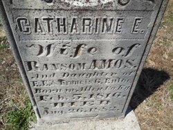
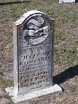
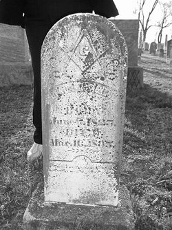
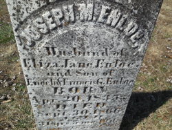
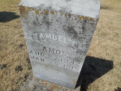
Catharine E Enloe Amos
| Birth | : | 5 Feb 1816 Allen County, Kentucky, USA |
| Death | : | 26 Aug 1882 Moniteau County, Missouri, USA |
| Burial | : | Anderson District Cemetery, Anderson, Shasta County, USA |
| Coordinate | : | 40.4419518, -122.2967300 |
| Plot | : | Section 1 |
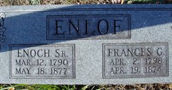
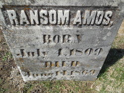
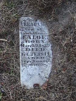
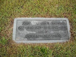
| Description | : | dau of Enoch E. & Frances G. Enloe wife of Ransom Amos |
frequently asked questions (FAQ):
-
Where is Catharine E Enloe Amos's memorial?
Catharine E Enloe Amos's memorial is located at: Anderson District Cemetery, Anderson, Shasta County, USA.
-
When did Catharine E Enloe Amos death?
Catharine E Enloe Amos death on 26 Aug 1882 in Moniteau County, Missouri, USA
-
Where are the coordinates of the Catharine E Enloe Amos's memorial?
Latitude: 40.4419518
Longitude: -122.2967300
Family Members:
Parent
Spouse
Siblings
Children


Nearby Cemetories:
1. Anderson District Cemetery
Anderson, Shasta County, USA
Coordinate: 40.4419518, -122.2967300
2. Oddfellows Cemetery
Anderson, Shasta County, USA
Coordinate: 40.4431590, -122.2907070
3. Anderson Pioneer Cemetery
Anderson, Shasta County, USA
Coordinate: 40.4439011, -122.2904968
4. Sleepy Hollow Pet Cemetery
Anderson, Shasta County, USA
Coordinate: 40.4199430, -122.2858410
5. Cottonwood Cemetery
Cottonwood, Shasta County, USA
Coordinate: 40.3856100, -122.2936500
6. Cottonwood Creek Ranch Cemetery
Cottonwood, Shasta County, USA
Coordinate: 40.3663100, -122.2598800
7. Major Pierson B Reading Family Cemetery
Cottonwood, Shasta County, USA
Coordinate: 40.3924300, -122.2126900
8. Parkville Cemetery
Anderson, Shasta County, USA
Coordinate: 40.4640200, -122.1897500
9. Haggard Family Ranch Cemetery
Palo Cedro, Shasta County, USA
Coordinate: 40.5105600, -122.2227800
10. Bates Pioneer Cemetery
Shasta County, USA
Coordinate: 40.5348816, -122.2968674
11. Happy Valley Cemetery
Redding, Shasta County, USA
Coordinate: 40.4668999, -122.4535980
12. Shasta General Hospital Cemetery
Redding, Shasta County, USA
Coordinate: 40.5509200, -122.3841800
13. Shasta General Hospital Cemetery
Redding, Shasta County, USA
Coordinate: 40.5516000, -122.3894000
14. Lawncrest Memorial Park
Redding, Shasta County, USA
Coordinate: 40.5732994, -122.3432999
15. Texas Springs Cemetery
Redding, Shasta County, USA
Coordinate: 40.5116844, -122.4516144
16. Millville Masonic Cemetery
Millville, Shasta County, USA
Coordinate: 40.5555000, -122.1842804
17. Beck Cemetery
Shasta County, USA
Coordinate: 40.5487400, -122.1720900
18. Millville IOOF Cemetery
Millville, Shasta County, USA
Coordinate: 40.5539017, -122.1663971
19. Old Saint Joseph Cemetery
Redding, Shasta County, USA
Coordinate: 40.5781326, -122.3912811
20. Inks Creek Cemetery
Tehama County, USA
Coordinate: 40.3419800, -122.1297100
21. Redding Memorial Park
Redding, Shasta County, USA
Coordinate: 40.5894814, -122.3872833
22. Middletown Cemetery
Redding, Shasta County, USA
Coordinate: 40.5392800, -122.4748700
23. Barbara Glass Gravesite
Shasta County, USA
Coordinate: 40.5067600, -122.5049700
24. Saint Joseph Cemetery
Redding, Shasta County, USA
Coordinate: 40.5824509, -122.4310989