
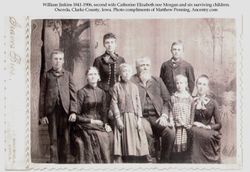
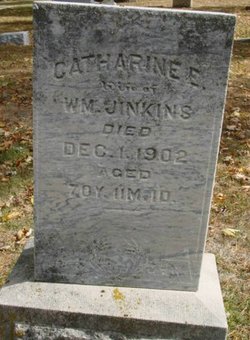
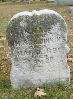
Catharine Elizabeth Morgan Jinkins
| Birth | : | 21 Dec 1831 Shelby County, Indiana, USA |
| Death | : | 1 Dec 1902 Osceola, Clarke County, Iowa, USA |
| Burial | : | St. Chad Churchyard, Kirkby, Metropolitan Borough of Knowsley, England |
| Coordinate | : | 53.4842890, -2.8930700 |
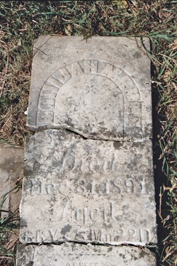
| Inscription | : | wife of Wm, aged 70 y 11 m 4 d |
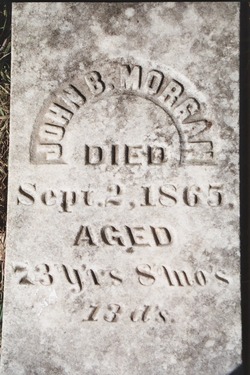
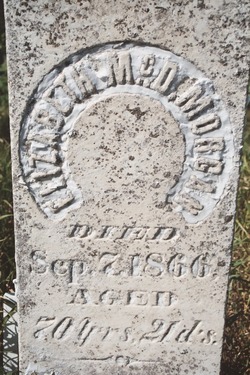
| Description | : | Catherine was born in Shelby County, IN to John Blair Morgan 1791-1865 and Elizabeth nee McDonald 1796-1866. She married William Jinkins 1831-1906 of Osceola, Clarke Co. IA on 9 Apr 1870 in Nodaway County, MO. It was her first marriage, William's second. William had four surviving children (of five) from his first marriage to Hester Ann nee Webster at the time of his marriage to Catherine: (Dora T. b. 1860, Arlington b. 1863, Addie Lenore b. 1865 and William Webster b. 1866. (Second-born child Eta Geneva b. 1861, d. 1862). William and Catherine would have three children, Margaret... Read More |
frequently asked questions (FAQ):
-
Where is Catharine Elizabeth Morgan Jinkins's memorial?
Catharine Elizabeth Morgan Jinkins's memorial is located at: St. Chad Churchyard, Kirkby, Metropolitan Borough of Knowsley, England.
-
When did Catharine Elizabeth Morgan Jinkins death?
Catharine Elizabeth Morgan Jinkins death on 1 Dec 1902 in Osceola, Clarke County, Iowa, USA
-
Where are the coordinates of the Catharine Elizabeth Morgan Jinkins's memorial?
Latitude: 53.4842890
Longitude: -2.8930700
Family Members:
Parent
Siblings
Children
Flowers:


Nearby Cemetories:
1. St. Chad Churchyard
Kirkby, Metropolitan Borough of Knowsley, England
Coordinate: 53.4842890, -2.8930700
2. Melling Churchyard
Melling, Metropolitan Borough of Sefton, England
Coordinate: 53.4953370, -2.9228780
3. St Thomas and the Holy Rood Churchyard
Melling, Metropolitan Borough of Sefton, England
Coordinate: 53.4954510, -2.9227850
4. St Swithins Churchyard
Liverpool, Metropolitan Borough of Liverpool, England
Coordinate: 53.4585631, -2.9012280
5. West Derby Cemetery
West Derby, Metropolitan Borough of Liverpool, England
Coordinate: 53.4513790, -2.9154630
6. West Derby Jewish Cemetery
Liverpool, Metropolitan Borough of Liverpool, England
Coordinate: 53.4504986, -2.9137393
7. Kirkdale Cemetery
Liverpool, Metropolitan Borough of Liverpool, England
Coordinate: 53.4672530, -2.9479800
8. St. Mary's Churchyard
Knowsley, Metropolitan Borough of Knowsley, England
Coordinate: 53.4561960, -2.8528580
9. Aintree Racecourse Grounds
Aintree Village, Metropolitan Borough of Sefton, England
Coordinate: 53.4733880, -2.9549700
10. St. Andrew Churchyard
Maghull, Metropolitan Borough of Sefton, England
Coordinate: 53.5104770, -2.9428820
11. Long Lane Jewish Cemetery
Liverpool, Metropolitan Borough of Liverpool, England
Coordinate: 53.4550140, -2.9420480
12. Everton Cemetery
Everton, Metropolitan Borough of Liverpool, England
Coordinate: 53.4555430, -2.9442480
13. Sefton Parish Churchyard
Sefton, Metropolitan Borough of Sefton, England
Coordinate: 53.5044060, -2.9712190
14. Rice Lane Jewish Cemetery
Walton, Metropolitan Borough of Liverpool, England
Coordinate: 53.4521700, -2.9590600
15. Friends Burial Ground
Bickerstaffe, West Lancashire District, England
Coordinate: 53.5347720, -2.8748780
16. GreenAcres Cemetery
Rainford, Metropolitan Borough of St Helens, England
Coordinate: 53.4713530, -2.8064280
17. Walton Park Cemetery
Walton, Metropolitan Borough of Liverpool, England
Coordinate: 53.4564370, -2.9695960
18. Bootle Cemetery
Bootle, Metropolitan Borough of Sefton, England
Coordinate: 53.4627680, -2.9787450
19. Yew Tree Roman Catholic Cemetery
West Derby, Metropolitan Borough of Liverpool, England
Coordinate: 53.4285700, -2.8790700
20. Holy Trinity Church
Bickerstaffe, West Lancashire District, England
Coordinate: 53.5318400, -2.8383400
21. St Mary the Virgin Churchyard
Walton, Metropolitan Borough of Liverpool, England
Coordinate: 53.4464930, -2.9673330
22. Ford Cemetery
Ford, Metropolitan Borough of Sefton, England
Coordinate: 53.4824040, -2.9925980
23. Saint Michael's Churchyard
Aughton, West Lancashire District, England
Coordinate: 53.5419170, -2.9197240
24. Anfield Cemetery and Crematorium
Anfield, Metropolitan Borough of Liverpool, England
Coordinate: 53.4354680, -2.9578100