

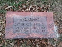
Catherine Gantz Brokmann
| Birth | : | 5 Sep 1866 Baldenheim, Departement du Bas-Rhin, Alsace, France |
| Death | : | 5 Dec 1944 Lawrence, Douglas County, Kansas, USA |
| Burial | : | Oak Hill Cemetery, Lawrence, Douglas County, USA |
| Coordinate | : | 38.9589005, -95.2118988 |
| Plot | : | Section 13 |
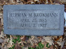
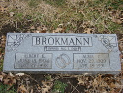
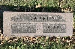
| Description | : | ~~~~~~~~~~~~~~~~~~~~~~~~~~~~~~~~~~~~~~~~~~ Daughter of Mathias Gantz. Catherine's mother died and was buried in Germany. Source: Contributor "Anonymous." ~~~~~~~~~~~~~~~~~~~~~~~~~~~~~~~~~~~~~~~~~~ Catherine married Frederick on January 4, 1893, in Willow Springs, KS ~~~~~~~~~~~~~~~~~~~~~~~~~~~~~~~~~~~~~~~~~~~ Mother of - Arthur G., b. abt. 1894, KS Herman M., b. abt 1895, KS Dorothy, b. abt. 1897, KS William, b. abt. 1903, KS Albert, b. abt. 1905, KS Carolina, b. abt. 1906, KS, #95653548 Emma, b. abt., 1909, KS ~~~~~~~~~~~~~~~~~~~~~~~~~~~~~~~~~~~~~~~~~~~~ |
frequently asked questions (FAQ):
-
Where is Catherine Gantz Brokmann's memorial?
Catherine Gantz Brokmann's memorial is located at: Oak Hill Cemetery, Lawrence, Douglas County, USA.
-
When did Catherine Gantz Brokmann death?
Catherine Gantz Brokmann death on 5 Dec 1944 in Lawrence, Douglas County, Kansas, USA
-
Where are the coordinates of the Catherine Gantz Brokmann's memorial?
Latitude: 38.9589005
Longitude: -95.2118988
Family Members:
Parent
Spouse
Siblings


Children
Flowers:


Nearby Cemetories:
1. Oak Hill Cemetery
Lawrence, Douglas County, USA
Coordinate: 38.9589005, -95.2118988
2. Mount Calvary Catholic Cemetery
Lawrence, Douglas County, USA
Coordinate: 38.9580002, -95.2139969
3. Memorial Park Cemetery
Lawrence, Douglas County, USA
Coordinate: 38.9552994, -95.2153015
4. Trinity Episcopal Church Columbarium
Lawrence, Douglas County, USA
Coordinate: 38.9653893, -95.2373886
5. Saint Johns Catholic Cemetery
Douglas County, USA
Coordinate: 38.9437900, -95.1919600
6. Dyche Hall Natural History Museum
Lawrence, Douglas County, USA
Coordinate: 38.9584800, -95.2434800
7. Franklin Cemetery
Douglas County, USA
Coordinate: 38.9437523, -95.1869431
8. Haskell Cemetery
Lawrence, Douglas County, USA
Coordinate: 38.9353790, -95.2284241
9. Pioneer Cemetery
Lawrence, Douglas County, USA
Coordinate: 38.9528008, -95.2611008
10. First Presbyterian Church Memorial Garden
Lawrence, Douglas County, USA
Coordinate: 38.9414900, -95.2641600
11. Maple Grove Cemetery
Lawrence, Douglas County, USA
Coordinate: 39.0018997, -95.2316971
12. County Poor Farm Cemetery
Douglas County, USA
Coordinate: 38.9119400, -95.2214600
13. Adams Cemetery
Douglas County, USA
Coordinate: 38.9955400, -95.2509100
14. Kennedy Cemetery
Douglas County, USA
Coordinate: 38.9112900, -95.2269200
15. Davis Cemetery
Lawrence, Douglas County, USA
Coordinate: 38.9722500, -95.2831100
16. Blue Mound Cemetery
Lawrence, Douglas County, USA
Coordinate: 38.9046600, -95.1865400
17. Marshall Cemetery
Douglas County, USA
Coordinate: 38.9040800, -95.2446700
18. Dutton Cemetery
Douglas County, USA
Coordinate: 38.8989800, -95.2790600
19. Luckan Family Cemetery
Fall Leaf, Leavenworth County, USA
Coordinate: 38.9808500, -95.1128000
20. Cemetery Beni Israel
Eudora, Douglas County, USA
Coordinate: 38.9280128, -95.1122208
21. Southwest City Cemetery
Eudora, Douglas County, USA
Coordinate: 38.9334800, -95.1070300
22. Lyon Family Cemetery
Lawrence, Douglas County, USA
Coordinate: 38.9877440, -95.3166530
23. Corpus Christi Catholic Church Columbarium
Lawrence, Douglas County, USA
Coordinate: 38.9572250, -95.3238450
24. Richland Cemetery
Lawrence, Douglas County, USA
Coordinate: 38.8768997, -95.2630997