
| Birth | : | 5 Jan 1842 Quebec, Canada |
| Death | : | 21 Jan 1915 Clyde, Cloud County, Kansas, USA |
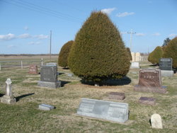
| Burial | : | Mount Calvary Cemetery, Clyde, Cloud County, USA |
| Coordinate | : | 39.5917015, -97.4143982 |
| Plot | : | Site D/5 |
| Inscription | : | 73y |
| Description | : | The Clyde Voice Republican Thursday January 28, 1915 Page 1 Mrs. Catherine Delude The subject of our sketch was born January 5, 1842 in Canada and passed away at her home in this city, Thursday, January 21, 1915, aged 73 years and 16 days. The cause of her death being acute gastritis. When a small child she moved with her parents to Manteno, Ill. There in 1867, she was married to Albert Delude. To this union seven children were born, one passing away in infancy. Fifty-four years ago, they moved to Kansas, locating in Nelson Township where they homesteaded.... Read More |
frequently asked questions (FAQ):
-
Where is Catherine M “Kate” Alexander Delude's memorial?
Catherine M “Kate” Alexander Delude's memorial is located at: Mount Calvary Cemetery, Clyde, Cloud County, USA.
-
When did Catherine M “Kate” Alexander Delude death?
Catherine M “Kate” Alexander Delude death on 21 Jan 1915 in Clyde, Cloud County, Kansas, USA
-
Where are the coordinates of the Catherine M “Kate” Alexander Delude's memorial?
Latitude: 39.5917015
Longitude: -97.4143982
Family Members:
Parent
Spouse

Siblings
Children
Flowers:


Nearby Cemetories:
1. Mount Calvary Cemetery
Clyde, Cloud County, USA
Coordinate: 39.5917015, -97.4143982
2. Mount Hope Cemetery
Clyde, Cloud County, USA
Coordinate: 39.5969009, -97.4116974
3. Cedar Grove Cemetery
Clyde, Cloud County, USA
Coordinate: 39.5494003, -97.4056015
4. Pleasant View Cemetery
Ames, Cloud County, USA
Coordinate: 39.5346985, -97.4431000
5. Walnut Grove Cemetery
Cloud County, USA
Coordinate: 39.5699997, -97.4993973
6. Saint Joseph Cemetery
Saint Joseph, Cloud County, USA
Coordinate: 39.5074941, -97.4022328
7. Agenda Cemetery
Agenda, Republic County, USA
Coordinate: 39.6761017, -97.4336014
8. Green Mound Cemetery
Rice, Cloud County, USA
Coordinate: 39.5248450, -97.5081630
9. Hollis Cemetery
Cloud County, USA
Coordinate: 39.6383018, -97.5361023
10. Beck Family Cemetery
Agenda, Republic County, USA
Coordinate: 39.6818000, -97.4863000
11. Rice Cemetery
Rice, Cloud County, USA
Coordinate: 39.5614014, -97.5552979
12. Nelson Cemetery
Rice, Cloud County, USA
Coordinate: 39.5257988, -97.5410995
13. Riverdale Cemetery
Clay County, USA
Coordinate: 39.5106010, -97.2930984
14. Saint Peters Cemetery
Aurora, Cloud County, USA
Coordinate: 39.4763985, -97.5180969
15. Princeville Cemetery
Aurora, Cloud County, USA
Coordinate: 39.4672012, -97.5010986
16. Iwacura Cemetery
Morganville, Clay County, USA
Coordinate: 39.4550000, -97.3510000
17. Union Cemetery
Wayne, Republic County, USA
Coordinate: 39.6977997, -97.5457993
18. Willoughby Cemetery
Agenda, Republic County, USA
Coordinate: 39.7402992, -97.4244003
19. French Presbyterian Church Cemetery
Cloud County, USA
Coordinate: 39.4395200, -97.4148290
20. Gotland Cemetery
Sibley Township, Cloud County, USA
Coordinate: 39.6091995, -97.6125031
21. Sherman Cemetery
Morganville, Clay County, USA
Coordinate: 39.5316300, -97.2243700
22. Zion Cemetery
Agenda, Republic County, USA
Coordinate: 39.6749992, -97.5939026
23. Rose Hill Cemetery
Wayne, Republic County, USA
Coordinate: 39.7111015, -97.5661011
24. Minersville Cemetery
Talmo, Republic County, USA
Coordinate: 39.6568330, -97.6229250