
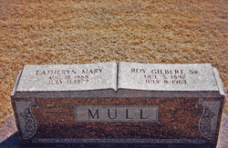

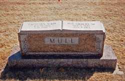
Catheryn Mary Schiereck Mull
| Birth | : | 18 Aug 1888 Dighton, Lane County, Kansas, USA |
| Death | : | 11 Jul 1979 Dighton, Lane County, Kansas, USA |
| Burial | : | Ebenezer Baptist Church Cemetery, Hendersonville, Henderson County, USA |
| Coordinate | : | 35.3498001, -82.4326019 |
frequently asked questions (FAQ):
-
Where is Catheryn Mary Schiereck Mull's memorial?
Catheryn Mary Schiereck Mull's memorial is located at: Ebenezer Baptist Church Cemetery, Hendersonville, Henderson County, USA.
-
When did Catheryn Mary Schiereck Mull death?
Catheryn Mary Schiereck Mull death on 11 Jul 1979 in Dighton, Lane County, Kansas, USA
-
Where are the coordinates of the Catheryn Mary Schiereck Mull's memorial?
Latitude: 35.3498001
Longitude: -82.4326019
Family Members:
Parent

Spouse
Siblings

Children
Flowers:


Nearby Cemetories:
1. Ebenezer Baptist Church Cemetery
Hendersonville, Henderson County, USA
Coordinate: 35.3498001, -82.4326019
2. Moores Grove Methodist Cemetery
Henderson County, USA
Coordinate: 35.3488007, -82.4318008
3. Seagle Cemetery
Henderson County, USA
Coordinate: 35.3553009, -82.4300003
4. Fair Haven Baptist Church Cemetery
Hendersonville, Henderson County, USA
Coordinate: 35.3447800, -82.4203100
5. Love Cemetery
Henderson County, USA
Coordinate: 35.3731003, -82.4289017
6. Forest Lawn Memorial Park
Henderson County, USA
Coordinate: 35.3225403, -82.4362411
7. Featherstone Family Cemetery
Henderson County, USA
Coordinate: 35.3817100, -82.4573500
8. Saint James Episcopal Church Cemetery
Hendersonville, Henderson County, USA
Coordinate: 35.3198874, -82.4610627
9. Bethel Wesleyan Church Cemetery
Henderson County, USA
Coordinate: 35.3157234, -82.4103165
10. Featherstone Slave Cemetery
Henderson County, USA
Coordinate: 35.3839389, -82.4571000
11. McCrary Family Cemetery
Henderson County, USA
Coordinate: 35.3366776, -82.4810562
12. Fruitland Cemetery
Henderson County, USA
Coordinate: 35.3833008, -82.4019012
13. Saint Matthews Cemetery
Hillgirt, Henderson County, USA
Coordinate: 35.3683014, -82.4792023
14. Tracy Grove Baptist Church
Henderson County, USA
Coordinate: 35.3142014, -82.4045029
15. Oakdale Cemetery
Hendersonville, Henderson County, USA
Coordinate: 35.3191986, -82.4753036
16. Grace Lutheran Church Memorial Garden
Hendersonville, Henderson County, USA
Coordinate: 35.3212100, -82.4786900
17. Dana United Methodist Church Cemetery
Dana, Henderson County, USA
Coordinate: 35.3367271, -82.3744049
18. Dana Baptist Church Cemetery
Dana, Henderson County, USA
Coordinate: 35.3395300, -82.3729300
19. Refuge Baptist Church Cemetery
Dana, Henderson County, USA
Coordinate: 35.3288002, -82.3751984
20. Lanning-Pittillo Cemetery
Henderson County, USA
Coordinate: 35.3939018, -82.4002991
21. Drake Family Cemetery
Henderson County, USA
Coordinate: 35.4025000, -82.4458060
22. Henderson County Home Cemetery
Henderson County, USA
Coordinate: 35.3535480, -82.4986540
23. First Congregational Church Memorial Garden
Hendersonville, Henderson County, USA
Coordinate: 35.3151530, -82.4841940
24. Hammett Family Cemetery
Upward, Henderson County, USA
Coordinate: 35.3090400, -82.3868630