
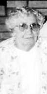
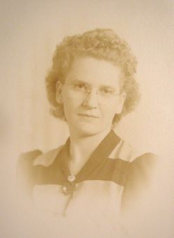
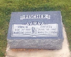
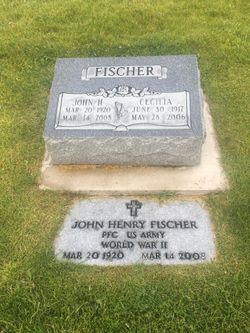
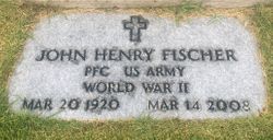
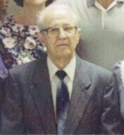
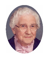
Cecilia Silbernagel Fischer
| Birth | : | 30 Jun 1917 Strasburg, Emmons County, North Dakota, USA |
| Death | : | 28 May 2006 Missoula, Missoula County, Montana, USA |
| Burial | : | St Thomas Becket Churchyard, Digby, North Kesteven District, England |
| Coordinate | : | 53.0796030, -0.3882980 |
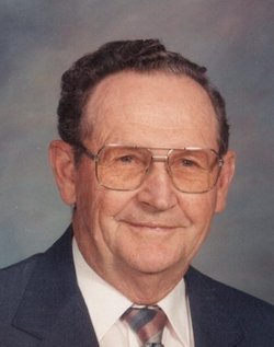
| Description | : | Cecilia Fischer, 88, died Sunday, May 28, 2006, in St. Patrick's Hospital, Missoula. Cecilia was born in Strasburg, N.D., on June 30, 1917. She was the third of 12 children to her parents, John and Angela (Miller) Silbernagel. On on April 17, 1948, in Bismarck, N.D., Cecilia married John H. Fischer. In 1949, they moved to Anaconda. Cecilia had numerous jobs, the last one being 14 years at St. Ann's Hospital, Anaconda. She enjoyed sewing, cooking, reading and mostly being with her family. She is survived by her husband, John; daughter, Janet Payne; grandchildren, Stacey Robinson and Chase Greene; great-granddaughter, Ramona Jane... Read More |
frequently asked questions (FAQ):
-
Where is Cecilia Silbernagel Fischer's memorial?
Cecilia Silbernagel Fischer's memorial is located at: St Thomas Becket Churchyard, Digby, North Kesteven District, England.
-
When did Cecilia Silbernagel Fischer death?
Cecilia Silbernagel Fischer death on 28 May 2006 in Missoula, Missoula County, Montana, USA
-
Where are the coordinates of the Cecilia Silbernagel Fischer's memorial?
Latitude: 53.0796030
Longitude: -0.3882980
Family Members:
Parent
Spouse
Siblings


Flowers:


Nearby Cemetories:
1. St Thomas Becket Churchyard
Digby, North Kesteven District, England
Coordinate: 53.0796030, -0.3882980
2. Holy Cross Churchyard
Kirkby Green, North Kesteven District, England
Coordinate: 53.1062300, -0.3808000
3. Holy Cross Churchyard
Scopwick, North Kesteven District, England
Coordinate: 53.1089480, -0.4032690
4. Holy Cross Churchyard Extension
Scopwick, North Kesteven District, England
Coordinate: 53.1105880, -0.4044990
5. All Saints Churchyard
Ruskington, North Kesteven District, England
Coordinate: 53.0460330, -0.3866280
6. All Saints Churchyard
Brauncewell, North Kesteven District, England
Coordinate: 53.0587900, -0.4418200
7. Anwick Church Lane Churchyard Extension
Anwick, North Kesteven District, England
Coordinate: 53.0420800, -0.3397200
8. St. Andrew's Churchyard
Timberland, North Kesteven District, England
Coordinate: 53.1095985, -0.3267715
9. St. Andrew's Churchyard
Timberland, North Kesteven District, England
Coordinate: 53.1095985, -0.3267715
10. St. Oswald Churchyard
Walcott, North Kesteven District, England
Coordinate: 53.0944560, -0.3128500
11. St Oswald Churchyard
Walcott, North Kesteven District, England
Coordinate: 53.0945800, -0.3125240
12. St. Oswald's Churchyard
Blankney, North Kesteven District, England
Coordinate: 53.1264910, -0.4051300
13. St Edith's Church
Anwick, North Kesteven District, England
Coordinate: 53.0414520, -0.3391170
14. St Wilfrid Churchyard
Metheringham, North Kesteven District, England
Coordinate: 53.1380350, -0.4016960
15. St Andrew Churchyard
Leasingham, North Kesteven District, England
Coordinate: 53.0239040, -0.4262600
16. St Andrew Churchyard
Cranwell, North Kesteven District, England
Coordinate: 53.0370660, -0.4612070
17. Billinghay Cemetery
Billinghay, North Kesteven District, England
Coordinate: 53.0806340, -0.2852800
18. Saint Luke Churchyard
North Kyme, North Kesteven District, England
Coordinate: 53.0591550, -0.2808970
19. St Michael Church Cemetery
Billinghay, North Kesteven District, England
Coordinate: 53.0796800, -0.2748100
20. St. Michael and All Angels Churchyard
Billinghay, North Kesteven District, England
Coordinate: 53.0791130, -0.2746370
21. St Peters Churchyard
Dunston, North Kesteven District, England
Coordinate: 53.1529600, -0.4120730
22. Sleaford Cemetery
Sleaford, North Kesteven District, England
Coordinate: 53.0027590, -0.4056790
23. St. Denys Churchyard
Kirkby la Thorpe, North Kesteven District, England
Coordinate: 53.0008270, -0.3636800
24. St Denys Churchyard
Sleaford, North Kesteven District, England
Coordinate: 52.9996510, -0.4088960