
| Birth | : | 1842 |
| Death | : | 11 Aug 1911 |
| Burial | : | All Saints Churchyard, Milford-on-Sea, New Forest District, England |
| Coordinate | : | 50.7278170, -1.5897770 |
| Plot | : | Sec. A/Area 5/Row 18/Plot 4 |
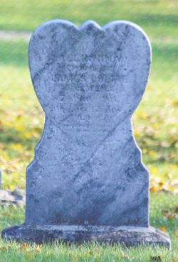
| Description | : | Daughter of J.B. Renaud. Wife of Israel Meloche.Ontario Death Records list cause of death as "tuberculosis."Tombstone inscription: "Celina/Wife of/Israel Meloche/Died 11 Aout 1911/Israel Meloche/Decede le 14 Aout 1914/Age de 68 ans." died 16 August 1911, death record https://www.familysearch.org/ark:/61903/3:1:3Q9M-C9TX-B9LL-X?i=1593&cc=1307826 |
frequently asked questions (FAQ):
-
Where is Celina Renaud Meloche's memorial?
Celina Renaud Meloche's memorial is located at: All Saints Churchyard, Milford-on-Sea, New Forest District, England.
-
When did Celina Renaud Meloche death?
Celina Renaud Meloche death on 11 Aug 1911 in
-
Where are the coordinates of the Celina Renaud Meloche's memorial?
Latitude: 50.7278170
Longitude: -1.5897770
Family Members:
Spouse

Children
Flowers:


Nearby Cemetories:
1. All Saints Churchyard
Milford-on-Sea, New Forest District, England
Coordinate: 50.7278170, -1.5897770
2. All Saints Churchyard
Hordle, New Forest District, England
Coordinate: 50.7549400, -1.6136200
3. St. Mark's Churchyard
Pennington, New Forest District, England
Coordinate: 50.7545700, -1.5631100
4. Lymington Cemetery
Lymington, New Forest District, England
Coordinate: 50.7576200, -1.5576200
5. Ashley Baptist Cemetery
New Milton, New Forest District, England
Coordinate: 50.7529200, -1.6336400
6. St. Thomas the Apostle Churchyard
Lymington, New Forest District, England
Coordinate: 50.7576410, -1.5451200
7. Milford Road Cemetery
New Milton, New Forest District, England
Coordinate: 50.7472700, -1.6502700
8. St Mary Magdalene Churchyard
New Milton, New Forest District, England
Coordinate: 50.7481200, -1.6645700
9. New Milton Cemetery
New Milton, New Forest District, England
Coordinate: 50.7507690, -1.6650340
10. St Luke Churchyard
Sway, New Forest District, England
Coordinate: 50.7839000, -1.6058800
11. Christ Church Totland Bay
Totland, Isle of Wight Unitary Authority, England
Coordinate: 50.6760770, -1.5448160
12. St Saviour Roman Catholic Churchyard
Totland, Isle of Wight Unitary Authority, England
Coordinate: 50.6762700, -1.5410390
13. St James Churchyard
Yarmouth, Isle of Wight Unitary Authority, England
Coordinate: 50.7055370, -1.4991890
14. All Saints Churchyard
Freshwater, Isle of Wight Unitary Authority, England
Coordinate: 50.6843570, -1.5102280
15. Sway Cemetery
Sway, New Forest District, England
Coordinate: 50.7930690, -1.6131930
16. St Mary Churchyard
South Baddesley, New Forest District, England
Coordinate: 50.7691430, -1.5026160
17. Hinton Park Woodland Burial Ground
Walkford, Christchurch Borough, England
Coordinate: 50.7572900, -1.6907090
18. St. John The Baptist Churchyard
Boldre, New Forest District, England
Coordinate: 50.7924070, -1.5422530
19. St Agnes Churchyard
Freshwater, Isle of Wight Unitary Authority, England
Coordinate: 50.6731050, -1.5173550
20. St. Swithin's Old Churchyard
Thorley, Isle of Wight Unitary Authority, England
Coordinate: 50.7007450, -1.4815300
21. St. Mark Churchyard
Highcliffe, Christchurch Borough, England
Coordinate: 50.7402900, -1.7100050
22. St Michael and All Angels Churchyard
Hinton, New Forest District, England
Coordinate: 50.7623700, -1.7002000
23. St Nicholas Churchyard
Brockenhurst, New Forest District, England
Coordinate: 50.8146060, -1.5681240
24. St Mary the Virgin Churchyard
Bransgore, New Forest District, England
Coordinate: 50.7766150, -1.7302940