
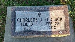
Charlene J. Ludwick
| Birth | : | 18 Feb 1926 Loretto, Boone County, Nebraska, USA |
| Death | : | 28 Feb 2001 Lincoln, Lancaster County, Nebraska, USA |
| Burial | : | St. Mary's Churchyard, Tarleton, West Lancashire District, England |
| Coordinate | : | 53.6746100, -2.8239200 |
| Description | : | Daughter of Allen H. & Emma E. (Jones) Ludwick. She worked at the State of Nebraska Motor Vehicle Department in Lincoln. She then moved to Loretto and worked at the Nebraska Health and Human Services Department in Boone County for about 45 years, serving as county director for many years. |
frequently asked questions (FAQ):
-
Where is Charlene J. Ludwick's memorial?
Charlene J. Ludwick's memorial is located at: St. Mary's Churchyard, Tarleton, West Lancashire District, England.
-
When did Charlene J. Ludwick death?
Charlene J. Ludwick death on 28 Feb 2001 in Lincoln, Lancaster County, Nebraska, USA
-
Where are the coordinates of the Charlene J. Ludwick's memorial?
Latitude: 53.6746100
Longitude: -2.8239200
Family Members:
Parent

Siblings

Flowers:


Nearby Cemetories:
1. St. Mary's Churchyard
Tarleton, West Lancashire District, England
Coordinate: 53.6746100, -2.8239200
2. Congregational Church
Bretherton, Chorley Borough, England
Coordinate: 53.6780260, -2.7986920
3. St. John the Baptist Churchyard
Bretherton, Chorley Borough, England
Coordinate: 53.6776300, -2.7952200
4. St. Michael and All Angel Churchyard
Much Hoole, South Ribble Borough, England
Coordinate: 53.6942950, -2.8143830
5. Becconsall Old Church Churchyard
Hesketh with Becconsall, West Lancashire District, England
Coordinate: 53.7023610, -2.8314810
6. Woodland Burial Ground
Much Hoole, South Ribble Borough, England
Coordinate: 53.6986390, -2.7974440
7. All Saints Churchyard
Hesketh with Becconsall, West Lancashire District, England
Coordinate: 53.7028189, -2.8400142
8. Croston Cemetery
Croston, Chorley Borough, England
Coordinate: 53.6586700, -2.7733100
9. Much Hoole Methodist Burial Ground
Much Hoole, South Ribble Borough, England
Coordinate: 53.7053750, -2.7951470
10. St. Mary the Virgin Churchyard
Rufford, West Lancashire District, England
Coordinate: 53.6349960, -2.8126410
11. Saint James Churchyard
Leyland, South Ribble Borough, England
Coordinate: 53.6896630, -2.7327430
12. St. Andrew's Churchyard
Longton, South Ribble Borough, England
Coordinate: 53.7263889, -2.7822222
13. St Mary the Virgin Churchyard
Eccleston, Chorley Borough, England
Coordinate: 53.6528800, -2.7331920
14. St. Peter's Churchyard
Mawdesley, Chorley Borough, England
Coordinate: 53.6237600, -2.7734100
15. St. Stephen's Churchyard
North Meols, West Lancashire District, England
Coordinate: 53.6813720, -2.9248140
16. St. Peter and St. Paul Churchyard
Mawdesley, Chorley Borough, England
Coordinate: 53.6266580, -2.7451420
17. St John the Baptist Churchyard
Burscough, West Lancashire District, England
Coordinate: 53.6042760, -2.8401390
18. Saint John Crossens Churchyard
Crossens, Metropolitan Borough of Sefton, England
Coordinate: 53.6733410, -2.9478740
19. St Mary's Roman Catholic Churchyard
Leyland, South Ribble Borough, England
Coordinate: 53.6880510, -2.6983240
20. Saint Andrews Churchyard
Leyland, South Ribble Borough, England
Coordinate: 53.6881270, -2.6957880
21. St Cuthberts Churchyard
Southport, Metropolitan Borough of Sefton, England
Coordinate: 53.6603230, -2.9620310
22. Holy Trinity Churchyard
Freckleton, Fylde Borough, England
Coordinate: 53.7543090, -2.8669130
23. St. Elizabeth's Churchyard
Scarisbrick, West Lancashire District, England
Coordinate: 53.6124460, -2.9206340
24. St John The Evangelist Roman Catholic Church
Burscough, West Lancashire District, England
Coordinate: 53.5902152, -2.8424163