
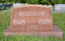


Charles Allen “Charley” Crawford
| Birth | : | 22 Apr 1884 High Prairie, Webster County, Missouri, USA |
| Death | : | 17 Apr 1952 Thayer, Oregon County, Missouri, USA |
| Burial | : | Waveland Cemetery, Pottawattamie County, USA |
| Coordinate | : | 41.1738700, -95.1881500 |
| Description | : | Son of Andrew "Jack" Jackson Crawford and Mary Ann (Cantrell) Crawford. Married Josie Ann Brewer before 1907. Father of Bertha C., Denver A., Ethel O., Harris H., Pauline, and Clida L. Married Martha Jane (Hall) Nibert in 1927 at Randolph Co., AR. Married Ramilla Easley after 1934. Farmer and blacksmith. Per MO Death certificate #17393, burial 20/Apr/1952. Birth taken from birth registry; all other records have April 17, 1884. |
frequently asked questions (FAQ):
-
Where is Charles Allen “Charley” Crawford's memorial?
Charles Allen “Charley” Crawford's memorial is located at: Waveland Cemetery, Pottawattamie County, USA.
-
When did Charles Allen “Charley” Crawford death?
Charles Allen “Charley” Crawford death on 17 Apr 1952 in Thayer, Oregon County, Missouri, USA
-
Where are the coordinates of the Charles Allen “Charley” Crawford's memorial?
Latitude: 41.1738700
Longitude: -95.1881500
Family Members:
Parent

Spouse

Siblings
Children


Nearby Cemetories:
1. Waveland Cemetery
Pottawattamie County, USA
Coordinate: 41.1738700, -95.1881500
2. Mercer Cemetery
Pottawattamie County, USA
Coordinate: 41.1753006, -95.1650009
3. Hillside Cemetery
Elliott, Montgomery County, USA
Coordinate: 41.1408005, -95.1544037
4. Pleasant Township Cemetery
Griswold, Cass County, USA
Coordinate: 41.2056000, -95.1370000
5. Flint Cemetery
Pottawattamie County, USA
Coordinate: 41.2289009, -95.1841965
6. Griswold Cemetery
Waveland Township, Pottawattamie County, USA
Coordinate: 41.2360992, -95.1735992
7. Center Ridge Cemetery
Montgomery County, USA
Coordinate: 41.1452141, -95.2787018
8. Lowman Cemetery
Griswold, Cass County, USA
Coordinate: 41.1594009, -95.0886002
9. Indian Graveyard
Sherman Township, Montgomery County, USA
Coordinate: 41.0955730, -95.1837580
10. L Laire Property Cemetery (Defunct)
Sherman Township, Montgomery County, USA
Coordinate: 41.0958257, -95.2224927
11. Pilot Grove Center Cemetery
Elliott, Montgomery County, USA
Coordinate: 41.1190600, -95.0993700
12. Smith Cemetery
Griswold, Cass County, USA
Coordinate: 41.2606010, -95.1453018
13. Haefflick Burial Site
Red Oak, Montgomery County, USA
Coordinate: 41.0726300, -95.1561700
14. Gomer Cemetery
Wales, Montgomery County, USA
Coordinate: 41.1171989, -95.3082962
15. Whipple Cemetery
Pottawattamie County, USA
Coordinate: 41.2882996, -95.1983032
16. Saint Clair Cemetery
Red Oak Township, Montgomery County, USA
Coordinate: 41.0598400, -95.2049810
17. Bradway Farm Cemetery
Macedonia, Pottawattamie County, USA
Coordinate: 41.2083300, -95.3336500
18. Buckner Cemetery
Wales, Montgomery County, USA
Coordinate: 41.1595600, -95.3440700
19. Wheeler Grove Cemetery
Macedonia, Pottawattamie County, USA
Coordinate: 41.2131691, -95.3393631
20. Mormon Cemetery
Macedonia, Pottawattamie County, USA
Coordinate: 41.1885986, -95.3557663
21. Pilot Grove Presbyterian Cemetery
Wallin, Montgomery County, USA
Coordinate: 41.0793991, -95.0699997
22. Saint Marys Cemetery
Red Oak, Montgomery County, USA
Coordinate: 41.0447006, -95.2275009
23. Grant Cemetery
Grant, Montgomery County, USA
Coordinate: 41.1405983, -94.9906006
24. Frankfort Cemetery
Montgomery County, USA
Coordinate: 41.0271988, -95.1327972